Herefordshire
Situé dans Angleterre, Royaume-Uni Coordonnées: 52°05′00″ N 2°45′00″ O
Le nom de ce lieu n'a pas encore été vérifié dans cette langue ; il est affiché sous sa forme d'origine.
- Population
- 191 047
- 191 k
- Altitude
- 81 m
- au-dessus du niveau de la mer
- Heure locale
- UTC+00:00
- Europe/London · UTC+00:00
- Lieux rattachés
- 240
- classés sous Herefordshire
À propos : Herefordshire
Herefordshire est un district. Situation : Angleterre, Royaume-Uni. Population : 191 047.
En comparaison
- 25 sites et lieux naturels à moins de 10 km Lyde Castle, Burghill
- Recensés ici : Commune: 240
Lieux : Herefordshire
240 lieux-
Docklow and Hampton Wafer Commune
-
Donnington Commune
-
Dormington Commune
-
Dorstone Commune
-
Downton Commune
-
Dulas Commune
-
Eardisland Commune
-
Eardisley Commune
-
Eastnor Commune
-
Eaton Bishop Commune
-
Edvin Loach and Saltmarshe Commune
-
Edwyn Ralph Commune
-
Eggleton Commune
-
Elton Commune
-
Evesbatch Commune
-
Ewyas Harold Commune
-
Eye, Moreton and Ashton Commune
-
Eyton Commune
-
Felton Commune
-
Ford and Stoke Prior Commune
-
Fownhope Commune
-
Foy Commune
-
Ganarew Commune
-
Garway Commune
-
Goodrich Commune
-
Grafton Commune
-
Grendon Bishop Commune
-
Hampton Bishop Commune
-
Hampton Charles Commune
-
Harewood Commune
-
Hatfield and Newhampton Commune
-
Haywood Commune
-
Hentland Commune
-
Hereford Commune
-
Holme Lacy Commune
-
Holmer & Shelwick Commune
-
Hope Mansell Commune
-
Hope under Dinmore Commune
-
How Caple Commune
-
Humber Commune
-
Huntington Commune
-
Kenchester Commune
-
Kenderchurch Commune
-
Kentchurch Commune
-
Kilpeck Commune
-
Kimbolton Commune
-
Kings Caple Commune
-
Kingsland Commune
-
King's Pyon Commune
-
Kingstone Commune
-
Kington Commune
-
Kington Rural Commune
-
Kinnersley Commune
-
Kinsham Commune
-
Knill Commune
-
Laysters Commune
-
Lea Commune
-
Ledbury Commune
-
Leinthall Starkes Commune
-
Leintwardine Commune
Sites et nature à proximité
Tout ce qui est proche-
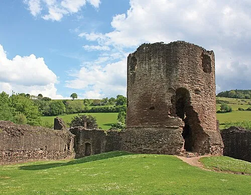 château de Skenfrith Site historique, Llangattock-Vibon-Avel23 km S
-
Goytre Wood Motte Site historique, Crucorney24 km SO
Sources et licences
Données mises à jour le: