Mersin
Nom local: Mersin ili
Situé dans Turquie Coordonnées: 36°51′43″ N 34°39′03″ E
- Population
- 1 954 279
- 2 M
- Altitude
- 73 m
- au-dessus du niveau de la mer
- Heure locale
- UTC+03:00
- Europe/Istanbul · UTC+03:00
- Lieux rattachés
- 437
- classés sous Mersin
À propos : Mersin
Mersin est une région. Situation : Turquie. Population : 1 954 279.
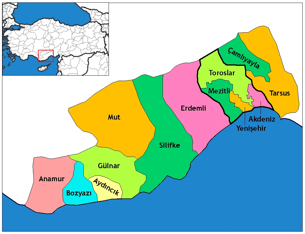
La province de Mersin est une des 81 provinces de la Turquie. Les anciennes provinces de Mersin (créée en 1924) et d’İçel fusionnèrent en 1933 sous le nom de province d’İçel, qui reprit le nom de province de Mersin en 2002. Sa préfecture se trouve dans la ville éponyme de Mersin.
Lire la suite sur Wikipédia Texte : contributeurs de Wikipédia · CC BY-SA 4.0 · abrégé
En bref
- Superficie
- 15 737 km²
Source : Wikidata
En comparaison
- 17 sites et lieux naturels à moins de 10 km Dalak Deresi, Yeşil Vadi Parkı
- Recensés ici : Site naturel: 168, Cours d’eau: 141, Montagne: 51, Village: 23
Lieux : Mersin
437 lieux-
Hasan Sarnıcı Site naturel
-
Hasanusta Deresi Cours d’eau
-
Hatinin Dere Cours d’eau
-
Hayılı Dere Cours d’eau
-
Himmet Pınarı Site naturel
-
Hımmet Pınarı Site naturel
-
Hızırözü Deresi Cours d’eau
-
Holamış Pınarı Site naturel
-
Hücre Deresi Cours d’eau
-
İgneağzı Boğazı Site naturel
-
İkiağızlı Çeşme Site naturel
-
İkizce Dere Cours d’eau
-
Ilgınkoyağı Deresi Cours d’eau
-
Ilgınsuyu Pınarı Site naturel
-
Ilıca Pınarı Site naturel
-
İncirlik Pınarı Site naturel
-
İncirli Pınar Site naturel
-
İncirlisu Pınarı Site naturel
-
İnicek Dere Cours d’eau
-
İnköyü Deresi Cours d’eau
-
Isazlı Pınar Site naturel
-
Kadıncık Deresi Cours d’eau
-
Kafesinsuyu Pınarı Site naturel
-
Kahve Tepesi Montagne
-
Kaldırvuk Deresi Cours d’eau
-
Kale Deresi Cours d’eau
-
Kale Tepe Montagne
-
Kandacık Pınarı Site naturel
-
Kandil Boğazı Site naturel
-
Kanlıkaya Tepesi Montagne
-
Kapız Boğazı Site naturel
-
Kapız Deresi Cours d’eau
-
Kaplanca Deresi Cours d’eau
-
Kaplan Pınarı Site naturel
-
Kaplan Pınarı Site naturel
-
Karaağaçlı Pınarı Site naturel
-
Karaağıl Yaylası Village
-
Karaalı Dere Cours d’eau
-
Karaboyalık Deresi Cours d’eau
-
Karabüvet Deresi Cours d’eau
-
Karaçal Tepe Montagne
-
Karacaören Çeşmesi Site naturel
-
Karaçay Deresi Cours d’eau
-
Karaçukur Deresi Cours d’eau
-
Karaerik Tepesi Montagne
-
Karagöz Deresi Cours d’eau
-
Karain Tepesi Montagne
-
Karain Tepesi Montagne
-
Karaketir Pınarı Site naturel
-
Karakoyak Deresi Cours d’eau
-
Karakuz Ormanı Site naturel
-
Karaoğlan Deresi Cours d’eau
-
Kara Pınar Site naturel
-
Kara Pınar Site naturel
-
Kara Pınar Site naturel
-
Karasazak Pınarı Site naturel
-
Karaveliler Pınarı Site naturel
-
Karayağdı Deresi Cours d’eau
-
Kargaalan Pınarı Site naturel
-
Kargılı Pınar Site naturel
Principales villes
-
Tarse Ville, Tarsus350,7 k
-
Taşucu Petite ville, Silifke İlçesi15,2 k
-
Arpaçbahşiş Petite ville, Erdemli İlçesi7,3 k
-
Atayurt Petite ville, Silifke İlçesi6,9 k
-
Çeşmeli Petite ville, Erdemli İlçesi5,9 k
-
Kocahasanlı Petite ville, Erdemli İlçesi5,7 k
-
Alifakı Petite ville, Tarsus6,6 k
-
Tırtar Village, Toroslar2,7 k
Nature et patrimoine : Mersin
-
Yellikaya Dağı Montagne, Mut
-
Hilldüz Hill Montagne, Anamur İlçesi
-
Tekeli Dağı Montagne, Erdemli İlçesi
-
Susuz Dağ Montagne, Gülnar İlçesi
-
Sivri Dağ Montagne, Mut
-
Sazlı Hill Montagne, Anamur İlçesi
Autres régions : Turquie
Sources et licences
Données mises à jour le: · 2 sources indépendantes