Cresta del Piano
Liegt in Campodolcino, Province of Sondrio Koordinaten: 46°23′59″ N 9°19′44″ O
- Höhe
- 2.054 m
- über dem Meeresspiegel
- Ortszeit
- UTC+01:00
- Europe/Rome · UTC+01:00
- Flughäfen
- LUG Lugano Airport55 km
- BGY Il Caravaggio International Airport86 km
Über Cresta del Piano
Cresta del Piano ist ein Berg. Lage: Campodolcino, Province of Sondrio. Höhe: 2.054 m. Nächster Flughafen: Lugano Airport (55 km). In der Nähe: Bel Motto und Motto Alto.
Fotos: Cresta del Piano
-
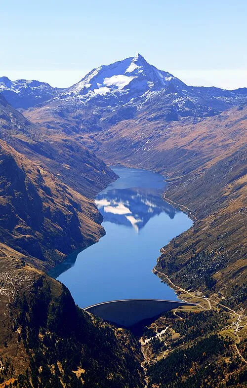
Pizzo Stella Capricorn4049 · CC BY-SA 4.0

Klima in Cresta del Piano
Dieser Monat · November
Ein regenreicher Monat
Tag 1° · Nacht -6° · Regen 112 mm
- Wärmster Monat
- Juli (Tag 14°)
- Kältester Monat
- Februar (Nacht -10°)
- Nassester Monat
- August (150 mm)
- Trockenster Monat
- Februar (68 mm)
Balken: mittlere Monatstiefst- und -höchsttemperatur. Darunter: Niederschlag. Monatsmittel 1970–2000 bei etwa 18 km Auflösung, höhenkorrigiert. Hervorgehobene Monate sind mild und relativ trocken. Quelle: WorldClim 2.1 (CC BY 4.0).
Werte als Tabelle anzeigen
| Monat | Jan | Feb | Mär | Apr | Mai | Jun | Jul | Aug | Sep | Okt | Nov | Dez |
|---|---|---|---|---|---|---|---|---|---|---|---|---|
| Mittleres Maximum (°C) | -2° | -2° | 0° | 2° | 7° | 11° | 14° | 14° | 10° | 6° | 1° | -1° |
| Mittleres Minimum (°C) | -9° | -10° | -7° | -5° | 0° | 3° | 5° | 5° | 3° | -1° | -6° | -8° |
| Niederschlag (mm) | 89 | 68 | 95 | 128 | 143 | 149 | 148 | 150 | 150 | 141 | 112 | 88 |
Anreise nach Cresta del Piano
Nächster Flughafen ist Lugano Airport (LUG), Luftlinie 55 km Richtung Südwesten. Für internationale Flüge: Il Caravaggio International Airport (BGY) (86 km). Nächste Großstadt ist Zürich, 123 km Richtung Nordwesten.
Flughäfen
- Lugano Airport (LUG) Agno 55 kmSüdwesten
- Il Caravaggio International Airport (BGY) Orio al Serio (BG) 86 kmSüden
- Milan Malpensa International Airport (MXP) Ferno (VA) 97 kmSüdwesten
Großstädte in der Nähe
- Zürich Einwohner: 415.367 123 kmNordwesten
- Winterthur Einwohner: 111.840 131 kmNorden
- Bern Einwohner: 121.631 156 kmNordwesten
- Innsbruck Einwohner: 132.493 184 kmNordosten
- Basel Einwohner: 177.595 186 kmNordwesten
Luftlinie; die Straßenentfernung ist länger. Flughafendaten: OurAirports.
Tagesausflüge ab Cresta del Piano
Im Umkreis von 100 km: 127 historische und kulturelle Stätten, 6.613 Naturorte, 790 Seen, Flüsse und Küsten.
0–25 km580 Orte
- Lajets See 23 kmNO
- Laghetto della Val Malvaglia See 23 kmW
- Lai da Calandari See 22 kmN
- Laghit de Agnon See 20 kmSW
25–60 km2.369 Orte
- Isole di Brissago Insel 55 kmSW
- Sant' Apollinare Insel 54 kmSW
- San Pancrazio Insel 55 kmSW
- Chaviolas Insel 32 kmO
60–100 km4.581 Orte
- Lago Nero See 61 kmW
- Insel Schwanau Insel 90 kmNW
- Seedamm Insel 100 kmNW
- Neptun-Inseln Insel 78 kmNW
Luftlinie.
Nächstgelegene Städte und Dörfer
-
Campodolcino Dorf, Campodolcino1,8 km O
-
 Prestone Dorf, Campodolcino2,2 km SO
-
Splughetta Dorf, Campodolcino1,5 km NO
-
 Starleggia Dorf, Campodolcino1,6 km N
-
 Fraciscio Dorf, Campodolcino2,9 km O
-
Motta di Sotto Dorf, Campodolcino3 km NO
Sehenswertes & Natur in der Nähe
Alles in der Nähe-
Bel Motto Berg, Campodolcino1,7 km S
-
Motto Alto Berg, Campodolcino2,5 km SW
-
Monte Tignoso Berg, Campodolcino2,5 km NW
-
Pizzo Truzzo Berg, San Giacomo Filippo2,9 km SW
-
Pizzo Camoscie Berg, San Giacomo Filippo3,9 km S
-
Pizzo Camoscero Berg, San Giacomo Filippo4,6 km S
-
La Colmenetta Berg, Campodolcino4,6 km NO
-
Motto di Bondeno Berg, San Giacomo Filippo4,6 km SO
Quellen & Lizenzen
Daten zuletzt aktualisiert: · 2 unabhängige Quellen