Municipality of Arta
Liegt in Nomós Ártas, Epirus Koordinaten: 39°09′35″ N 20°59′08″ O
Der Name dieses Ortes wurde in dieser Sprache noch nicht verifiziert und wird in der Originalform angezeigt.
- Höhe
- 52 m
- über dem Meeresspiegel
- Ortszeit
- UTC+02:00
- Europe/Athens · UTC+02:00
- Orte darin
- 71
- unter Municipality of Arta verzeichnet
- Flughäfen
- PVK Aktion National Airport32 km
- IOA Ioannina King Pyrrhus National Airport61 km
Über Municipality of Arta
Municipality of Arta ist eine Gemeinde. Lage: Nomós Ártas, Epirus. Höhe: 52 m. Die beste Reisezeit: April–Mai, Oktober. Nächster Flughafen: Aktion National Airport (32 km). In der Nähe: Makronisi (Arta) und Retha monastery.
Fotos: Municipality of Arta
-
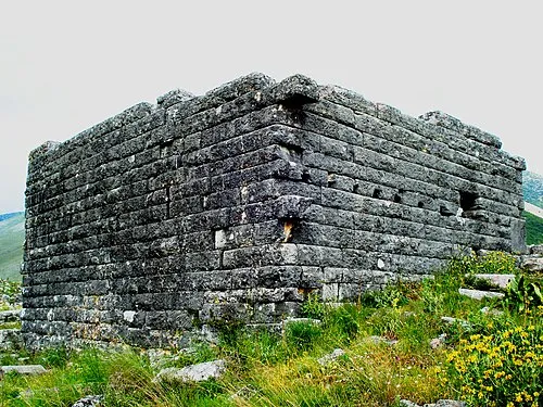
Orraon Φωτο Χ. Γκούβας · CC BY-SA 3.0 -
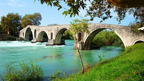
Brücke von Arta The original uploader was Harrygouvas at Greek Wikipedia · CC BY-SA 3.0


Klima in Municipality of Arta
Beste Monate für BesichtigungenBeste Monate für Besichtigungen: April–Mai, Oktober.
Dieser Monat · November
Ein regenreicher Monat
Tag 17° · Nacht 8° · Regen 150 mm
- Wärmster Monat
- Juli (Tag 32°)
- Kältester Monat
- Januar (Nacht 4°)
- Nassester Monat
- November (150 mm)
- Trockenster Monat
- Juli (12 mm)
Balken: mittlere Monatstiefst- und -höchsttemperatur. Darunter: Niederschlag. Monatsmittel 1970–2000 bei etwa 18 km Auflösung, höhenkorrigiert. Hervorgehobene Monate sind mild und relativ trocken. Quelle: WorldClim 2.1 (CC BY 4.0).
Werte als Tabelle anzeigen
| Monat | Jan | Feb | Mär | Apr | Mai | Jun | Jul | Aug | Sep | Okt | Nov | Dez |
|---|---|---|---|---|---|---|---|---|---|---|---|---|
| Mittleres Maximum (°C) | 12° | 13° | 16° | 19° | 24° | 29° | 32° | 32° | 29° | 23° | 17° | 13° |
| Mittleres Minimum (°C) | 4° | 4° | 6° | 9° | 13° | 16° | 18° | 18° | 16° | 12° | 8° | 5° |
| Niederschlag (mm) | 102 | 112 | 82 | 61 | 37 | 18 | 12 | 17 | 46 | 98 | 150 | 141 |
Anreise nach Municipality of Arta
Nächster Flughafen ist Aktion National Airport (PVK), Luftlinie 32 km Richtung Südwesten. Für internationale Flüge: Corfu Ioannis Kapodistrias International Airport (CFU) (105 km). Nächste Großstadt ist Piräus, 268 km Richtung Südosten.
Flughäfen
- Aktion National Airport (PVK) Preveza 32 kmSüdwesten
- Ioannina King Pyrrhus National Airport (IOA) Ioannina 61 kmNorden
- Corfu Ioannis Kapodistrias International Airport (CFU) Kerkyra (Corfu) 105 kmNordwesten
Großstädte in der Nähe
- Piräus Einwohner: 163.688 268 kmSüdosten
- Athen Einwohner: 664.046 272 kmSüdosten
Luftlinie; die Straßenentfernung ist länger. Flughafendaten: OurAirports.
Tagesausflüge ab Municipality of Arta
Im Umkreis von 100 km: 11 historische und kulturelle Stätten, 26 Seen, Flüsse und Küsten.
0–25 km5 Orte
- Retha monastery Sehenswürdigkeit 23 kmSO
- Makronisi (Arta) Insel 18 kmSW
- Kefalos Insel 24 kmSW
- Orraon Historische Stätte 13 kmNW
25–60 km6 Orte
- Moni Tatarnas Sehenswürdigkeit 52 kmSO
- Monastery of the Cave, Karditsa Sehenswürdigkeit 47 kmO
- Forti Aitoloakarnanias Insel 45 kmSW
- Panagia Insel 52 kmW
60–100 km26 Orte
- Kablafka Strand 68 kmS
- Nisída Sáranta Insel 100 kmSO
- Nisídes Falarídes Insel 92 kmS
- Moni pantanassas Sehenswürdigkeit 69 kmN
Luftlinie.
Orte in Municipality of Arta
71 Orte- 1 Kostakioi 2078
- 2 Chalkiades 1284
- 3 Grammenitsa 1258
- 4 Aneza 1111
- 5 Eleousa 1093
- 6 Kalamia 1018
- 7 Agios Spyridon 971
- 8 Kampi 928
- 9 Agioi Anargyroi 756
- 10 Ammotopos 618
- 11 Rokka 613
- 12 Kalovatos 589
- 13 Rachi 574
- 14 Kalogeriko 491
- 15 Kirkizates 466
- 16 Keramates 411
- 17 Polydroso 408
- 18 Elatos 407
- 19 Vigla 386
- 20 Gavria 379
- 21 Vlacherna 374
- 22 Plisioi 356
- 23 Ampelia 350
- 24 Glykorrizo 325
- 25 Limini 317
- 26 Chanopoulo 313
- 27 Pantanassa 293
- 28 Rodavgi 257
- 29 Grimpovo 211
- 30 Psathotopi 194
- 31 Strongyli 192
- 32 Mytikas 190
- 33 Koronisia 165
- 34 Platania 164
- 35 Korfovouni 159
- 36 Apomero 142
- 37 Agia Triada 136
- 38 Moni Genisseos Theotokou 87
- 39 Dafnoti 85
- 40 Perdikári 84
- 41 Skamnia 84
- 42 Marathovouni 82
- 43 Anogeiata 73
- 44 Thanasaiika 73
- 45 Faneromeni 63
- 46 Vathypedo 59
- 47 Kakovatos 58
- 48 Agios Georgios Glykorrizou 53
- 49 Soumesi 52
- 50 Skoupa 46
- 51 Pistiana 43
- 52 Palaioskamia 36
- 53 Dryonas 35
- 54 Dafni 31
- 55 Kallithea 31
- 56 Vrysoules 31
- 57 Dokimia 29
- 58 Syngouneika 24
- 59 Kampos 22
- 60 Zarkadaiika 22
Balken: Einwohnerzahl im Verhältnis zum bevölkerungsreichsten Ort dieser Liste.
Sehenswertes & Natur in der Nähe
Alles in der Nähe-
Makronisi (Arta) Insel, Nomós Ártas18 km SW
-
Retha monastery Sehenswürdigkeit, Amfilochia23 km SO
-
Kefalos Insel, Westgriechenland24 km SW
Quellen & Lizenzen
Daten zuletzt aktualisiert: