Zakynthos
Liegt in Nomós Zakýnthou, Ionische Inseln Koordinaten: 37°47′00″ N 20°46′31″ O
Der Name dieses Ortes wurde in dieser Sprache noch nicht verifiziert und wird in der Originalform angezeigt.
- Einwohner
- 38.883
- 38.883
- Höhe
- 297 m
- über dem Meeresspiegel
- Ortszeit
- UTC+02:00
- Europe/Athens · UTC+02:00
- Orte darin
- 84
- unter Zakynthos verzeichnet
- Flughäfen
- ZTH Zakynthos International Airport "Dionysios Solomos"10 km
- EFL Kefalonia International Airport "Anna Pollatou"45 km
Über Zakynthos
Zakynthos ist eine Gemeinde. Lage: Nomós Zakýnthou, Ionische Inseln. Einwohner: 38.883. Höhe: 297 m. Die beste Reisezeit: Mai–Juli, September. Nächster Flughafen: Zakynthos International Airport "Dionysios Solomos" (10 km).
Fotos: Zakynthos
-
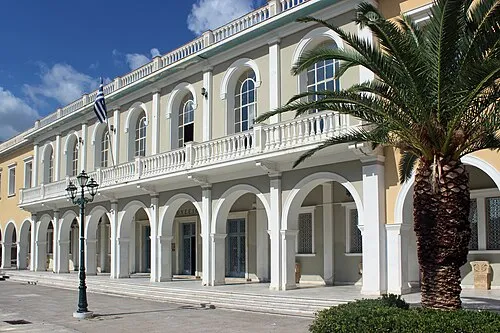
Byzantine Museum of Zakynthos Maesi64 · CC0

Klima in Zakynthos
Beste Monate für BesichtigungenBeste Monate für Besichtigungen: Mai–Juli, September.
Dieser Monat · November
Ein regenreicher Monat
Tag 17° · Nacht 10° · Regen 157 mm
- Wärmster Monat
- August (Tag 29°)
- Kältester Monat
- Januar (Nacht 6°)
- Nassester Monat
- Dezember (176 mm)
- Trockenster Monat
- Juli (7 mm)
Balken: mittlere Monatstiefst- und -höchsttemperatur. Darunter: Niederschlag. Monatsmittel 1970–2000 bei etwa 18 km Auflösung, höhenkorrigiert. Hervorgehobene Monate sind mild und relativ trocken. Quelle: WorldClim 2.1 (CC BY 4.0).
Werte als Tabelle anzeigen
| Monat | Jan | Feb | Mär | Apr | Mai | Jun | Jul | Aug | Sep | Okt | Nov | Dez |
|---|---|---|---|---|---|---|---|---|---|---|---|---|
| Mittleres Maximum (°C) | 12° | 12° | 14° | 17° | 22° | 26° | 29° | 29° | 26° | 21° | 17° | 14° |
| Mittleres Minimum (°C) | 6° | 6° | 7° | 9° | 13° | 16° | 19° | 19° | 17° | 14° | 10° | 7° |
| Niederschlag (mm) | 143 | 110 | 90 | 56 | 24 | 10 | 7 | 11 | 39 | 126 | 157 | 176 |
Anreise nach Zakynthos
Nächster Flughafen ist Zakynthos International Airport "Dionysios Solomos" (ZTH), Luftlinie 10 km Richtung Osten. Nächste Großstadt ist Piräus, 253 km Richtung Osten.
Flughäfen
- Zakynthos International Airport "Dionysios Solomos" (ZTH) Zakynthos 10 kmOsten
- Kefalonia International Airport "Anna Pollatou" (EFL) Kefallinia Island 45 kmNordwesten
- Patras Araxos Agamemnon Airport (GPA) Patras 70 kmNordosten
Großstädte in der Nähe
- Piräus Einwohner: 163.688 253 kmOsten
- Athen Einwohner: 664.046 261 kmOsten
Luftlinie; die Straßenentfernung ist länger. Flughafendaten: OurAirports.
Tagesausflüge ab Zakynthos
Im Umkreis von 100 km: 10 historische und kulturelle Stätten, 23 Seen, Flüsse und Küsten.
0–25 km1 Ort
- Byzantine Museum of Zakynthos Museum 11 kmO
25–60 km10 Orte
- Kefalonia Insel 54 kmN
- Agios Andreas Milapidias monastery Sehenswürdigkeit 43 kmNW
- Panagia Kipouraion monastery Sehenswürdigkeit 60 kmNW
- Moni Theotokou Atrou Sehenswürdigkeit 42 kmN
60–100 km22 Orte
- Nisídes Falarídes Insel 67 kmNO
- Vasiliko islet Insel 86 kmNO
- Skartsoumbonisi Ithakis Insel 66 kmN
- Nisída Sáranta Insel 85 kmNO
Luftlinie.
Orte in Zakynthos
84 Orte- 61 Kampi 59
- 62 Korithi 48
- 63 Loucha 46
- 64 Melinado 45
- 65 Mikro Nisi 38
- 66 Agia Thekli 36
- 67 Apelati 35
- 68 Giri 34
- 69 Chamouzas 33
- 70 Askos 31
- 71 Marathias, Zakynthos 31
- 72 Varvara 30
- 73 Elies 26
- 74 Limontaiika 20
- 75 Koroni 10
- 76 Stimies 9
- 77 Agios Ioannis 8
- 78 Ai Giannis 8
- 79 Fterini 7
- 80 Kastelia 7
- 81 Psaraiika 7
- 82 Ampelos 2
- 83 Moni Strofadon 1
Balken: Einwohnerzahl im Verhältnis zum bevölkerungsreichsten Ort dieser Liste.
Kulturerbe & Sehenswertes1
- Byzantine Museum of Zakynthos · Museum
Quellen & Lizenzen
Daten zuletzt aktualisiert: