- Local time
- UTC+03:00
- Europe/Istanbul · UTC+03:00
- Elevation
- 58 m
- above sea level
- Airports
- COV Çukurova International Airport72 km
- KCM Kahramanmaraş Airport113 km
About Ağa Köprüsü
Ağa Köprüsü is a landmark. Location: İmamoğlu, Adana Province. The best months to visit are April, November. The nearest airport is Çukurova International Airport (72 km). Nearby sights include Baltalı Dere and Andvorza Harabesi.
Climate of Ağa Köprüsü
Best months for sightseeingBest months for sightseeing: April, November.
This month · November
A good month to visit
Day 23° · Night 10° · Rain 70 mm
- Hottest month
- July (day 36°)
- Coldest month
- January (night 5°)
- Wettest month
- December (123 mm)
- Driest month
- August (14 mm)
Bars: average monthly low and high temperature. Below: precipitation. Monthly averages for 1970–2000 at about 18 km resolution, adjusted for elevation. Highlighted months are mild and relatively dry. Source: WorldClim 2.1 (CC BY 4.0).
Show values as a table
| Month | Jan | Feb | Mar | Apr | May | Jun | Jul | Aug | Sep | Oct | Nov | Dec |
|---|---|---|---|---|---|---|---|---|---|---|---|---|
| Average high (°C) | 15° | 16° | 19° | 24° | 28° | 33° | 36° | 36° | 34° | 29° | 23° | 17° |
| Average low (°C) | 5° | 6° | 8° | 12° | 15° | 19° | 23° | 23° | 20° | 15° | 10° | 7° |
| Precipitation (mm) | 108 | 87 | 87 | 77 | 66 | 37 | 15 | 14 | 22 | 57 | 70 | 123 |
How to get to Ağa Köprüsü
The nearest airport is Çukurova International Airport (COV), 72 km to the southwest as the crow flies. The nearest large city is Adana, 49 km to the southwest.
Airports
- Çukurova International Airport (COV) Tarsus 72 kmsouthwest
- Kahramanmaraş Airport (KCM) Kahramanmaraş 113 kmeast
- Hatay Airport (HTY) Antakya 116 kmsoutheast
Nearby large cities
- Adana Population: 1.8M 49 kmsouthwest
- Osmaniye Population: 202.8K 54 kmsoutheast
- Tarsus Population: 350.7K 84 kmsouthwest
- İskenderun Population: 251.7K 89 kmsoutheast
- Arsuz Population: 109.6K 99 kmsouth
Straight-line distances; road distances are longer. Airport data: OurAirports.
Day trips from Ağa Köprüsü
Within 100 km: 31 historic and cultural sites, 396 natural sites, 244 lakes, rivers and coasts.
0–25 km29 places
- Yağızlar Göleti Lake 18 kmSW
- Sarıağaç Tepe Mountain 24 kmNE
- İncirliören Tepe Mountain 16 kmW
- Hanyeri Tepesi Mountain 18 kmNE
25–60 km135 places
- Karatepe Aslantaşı Milli Parkı Natural site 48 kmE
- Seyhan Barajı Lake 43 kmSW
- Ziyaret Tepesi Mountain 56 kmE
- Ziyaret Tepe Mountain 55 kmN
60–100 km507 places
- Küçük Ada Island 85 kmS
- Nergizi Adasi Island 78 kmS
- Ömer Gölü Island 64 kmS
- Yapı Gölü Lake 66 kmS
Straight-line distances.
Nearby attractions & nature
Everything nearby-
Baltalı Dere River, Adana Province5.3 km S
-
Andvorza Harabesi Historic site, Kozan16 km E
-
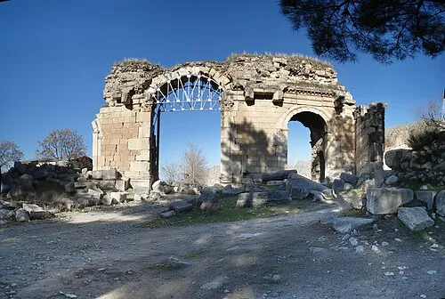 Anazarbus Historic site, Kozan18 km E
-
Taşlıgeçek Deresi River, Adana Province8.1 km W
-
Anavarza Kalesi Historic site, Kozan18 km E
-
İncirliören Tepe Mountain, İmamoğlu16 km W
-
Kırksu Deresi River, Adana Province11 km NE
-
Sevinçli Dere River, Adana Province11 km W
Nearest towns and villages
-
Ayvalı Village, İmamoğlu2.1 km E
-
 Ağzıkaraca Village, İmamoğlu4 km NW
-
Ufacıkören Village, İmamoğlu4.1 km N
-
 Koyunevi Village, İmamoğlu5 km W
Sources & licences
Data last updated: