- Ortszeit
- UTC+00:00
- Europe/London · UTC+00:00
- Höhe
- 81 m
- über dem Meeresspiegel
- Flughäfen
- LPL Liverpool John Lennon Airport63 km
- MAN Manchester Airport78 km
Über Kinton Motte
Kinton Motte ist eine historische Stätte. Lage: Great Ness, Shropshire. Die beste Reisezeit: Juni–August. Nächster Flughafen: Liverpool John Lennon Airport (63 km). In der Nähe: Little Ness Castle Mound und Knockin Castle.
Fotos: Kinton Motte
-
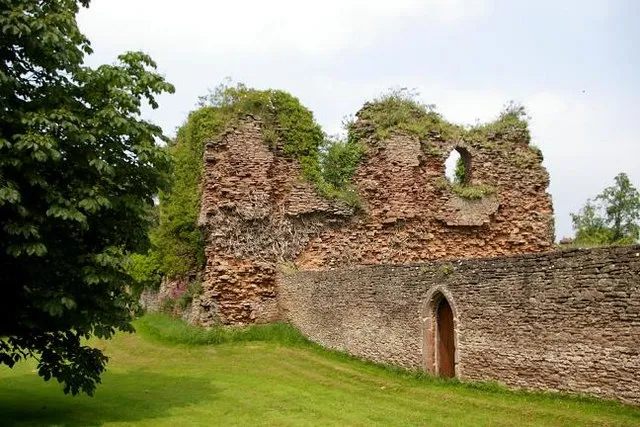
Alberbury Castle Peter Craine · CC BY-SA 2.0

Klima in Kinton Motte
Beste Monate für BesichtigungenBeste Monate für Besichtigungen: Juni–August.
Dieser Monat · November
Ein kalter Monat
Tag 10° · Nacht 3° · Regen 74 mm
- Wärmster Monat
- Juli (Tag 21°)
- Kältester Monat
- Februar (Nacht 1°)
- Nassester Monat
- Dezember (75 mm)
- Trockenster Monat
- Juli (49 mm)
Balken: mittlere Monatstiefst- und -höchsttemperatur. Darunter: Niederschlag. Monatsmittel 1970–2000 bei etwa 18 km Auflösung, höhenkorrigiert. Hervorgehobene Monate sind mild und relativ trocken. Quelle: WorldClim 2.1 (CC BY 4.0).
Werte als Tabelle anzeigen
| Monat | Jan | Feb | Mär | Apr | Mai | Jun | Jul | Aug | Sep | Okt | Nov | Dez |
|---|---|---|---|---|---|---|---|---|---|---|---|---|
| Mittleres Maximum (°C) | 7° | 7° | 10° | 12° | 16° | 18° | 21° | 20° | 17° | 14° | 10° | 8° |
| Mittleres Minimum (°C) | 1° | 1° | 2° | 3° | 6° | 9° | 11° | 11° | 9° | 6° | 3° | 2° |
| Niederschlag (mm) | 70 | 52 | 58 | 52 | 52 | 57 | 49 | 63 | 67 | 69 | 74 | 75 |
Anreise nach Kinton Motte
Nächster Flughafen ist Liverpool John Lennon Airport (LPL), Luftlinie 63 km Richtung Norden. Nächste Großstadt ist Telford, 34 km Richtung Osten.
Flughäfen
- Liverpool John Lennon Airport (LPL) Liverpool 63 kmNorden
- Manchester Airport (MAN) Manchester, Greater Manchester 78 kmNordosten
- Birmingham Airport (BHX) Birmingham, West Midlands 88 kmSüdosten
Großstädte in der Nähe
- Telford Einwohner: 155.570 34 kmOsten
- Newcastle-under-Lyme Einwohner: 127.727 54 kmNordosten
- Stoke-on-Trent Einwohner: 258.366 57 kmNordosten
- Wolverhampton Einwohner: 263.700 59 kmOsten
- Dudley Einwohner: 199.059 65 kmSüdosten
Luftlinie; die Straßenentfernung ist länger. Flughafendaten: OurAirports.
Tagesausflüge ab Kinton Motte
Im Umkreis von 100 km: 881 historische und kulturelle Stätten, 2.470 Naturorte, 187 Seen, Flüsse und Küsten.
0–25 km272 Orte
- Newton Mere See 16 kmN
- Crose Mere See 13 kmNO
- Hawkstone lake See 23 kmNO
- Reservoir See 17 kmSO
25–60 km1.174 Orte
- The Island Insel 58 kmS
- Ynys Goediog Insel 57 kmW
- Duckbay Island Insel 33 kmNO
- Lake Vyrnwy See 38 kmW
60–100 km2.092 Orte
- Thurstaston Beach Strand 65 kmN
- Formby Beach Strand 89 kmN
- Ainsdale Beach Strand 94 kmN
- Ynys Tywyn Insel 82 kmW
Luftlinie.
Sehenswertes & Natur in der Nähe
Alles in der Nähe-
Little Ness Castle Mound Historische Stätte, Little Ness3,8 km O
-
Knockin Castle Historische Stätte, Knockin4,5 km NW
-
Alberbury Castle Historische Stätte, Alberbury with Cardeston5,2 km S
-
Little Shrawardine Castle Historische Stätte, Alberbury with Cardeston4,9 km SO
-
Ringwork and bailey castle 100m north east of Heath Farm Historische Stätte, Alberbury with Cardeston8,2 km S
-
Motte castle 200m south west of Bretchel Historische Stätte, Alberbury with Cardeston8,4 km SW
-
Moated site, prospect mound and fishponds adjacent to Isle Farm Historische Stätte, Bicton9,2 km O
-
Ringwork and bailey castle 350m south west of Lyndale Historische Stätte, Westbury9,2 km S
Quellen & Lizenzen
Daten zuletzt aktualisiert: · 2 unabhängige Quellen