Schloßberg
Located in Lower Austria, Austria Coordinates: 48°53′25″ N 15°37′35″ E
- Local time
- UTC+01:00
- Europe/Vienna · UTC+01:00
- Elevation
- 451 m
- above sea level
About Schloßberg
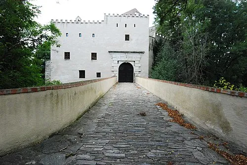
Schloßberg is a historic site. Location: Lower Austria, Austria.
In comparison
- 41 sights and natural places within 10 km Gaberbach, Gaberkirche
Nearby attractions & nature
Everything nearby-
Gaberbach River, Lower Austria0.6 km E
-
Gaberkirche Historic site, Drosendorf-Zissersdorf2.6 km W
-
Gaberwald Natural site, Lower Austria3.1 km W
-
V Pekle Mountain, Stálky3.1 km SE
-
Frattingbach River, Lower Austria3.4 km NW
-
Thumeritz River, Lower Austria2.7 km S
-
Bründlbach River, Lower Austria4.3 km SE
-
Schachenbach River, Lower Austria3.1 km SW
Nearest towns and villages
-
Unterthürnau Village, Drosendorf-Zissersdorf1.1 km SW
-
Drosendorf Village, Drosendorf-Zissersdorf2.6 km S
-
Uherčice Village, Uherčice2.6 km N
-
Oberthürnau Village, Drosendorf-Zissersdorf2.1 km W
More sights in Lower Austria
-
Ruine Kollmitz Historic site, Raabs an der Thaya9 km SW
-
Schafbrücke Landmark, Lower Austria9.8 km NW
-
Ruine Buchenstein Historic site, Raabs an der Thaya12 km W
-
Hartbrücke Landmark, Weitersfeld15 km SE
-
Ruine Kaja Historic site, Hardegg20 km E
-
 Schloss Wildberg Historic site, Irnfritz-Messern20 km S
Sources & licences
Data last updated: