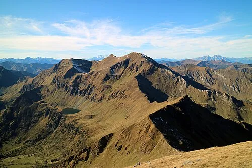
Schoberspitze
Located in Oberwölz, Politischer Bezirk Murau Coordinates: 47°17′00″ N 14°09′00″ E
- Elevation
- 2,423 m
- above sea level
- Local time
- UTC+01:00
- Europe/Vienna · UTC+01:00
- Airports
- KLU Klagenfurt Airport73 km
- GRZ Graz Airport103 km
About Schoberspitze
Schoberspitze is a mountain. Location: Oberwölz, Politischer Bezirk Murau. Elevation: 2,423 m. The nearest airport is Klagenfurt Airport (73 km). Nearby sights include Bernkadlereck and Idlereck.
Climate of Schoberspitze
This month · November
A wet month
Day -3° · Night -10° · Rain 128 mm
- Hottest month
- July (day 10°)
- Coldest month
- January (night -14°)
- Wettest month
- July (196 mm)
- Driest month
- February (80 mm)
Bars: average monthly low and high temperature. Below: precipitation. Monthly averages for 1970–2000 at about 18 km resolution, adjusted for elevation. Highlighted months are mild and relatively dry. Source: WorldClim 2.1 (CC BY 4.0).
Show values as a table
| Month | Jan | Feb | Mar | Apr | May | Jun | Jul | Aug | Sep | Oct | Nov | Dec |
|---|---|---|---|---|---|---|---|---|---|---|---|---|
| Average high (°C) | -7° | -6° | -4° | -1° | 5° | 8° | 10° | 10° | 7° | 3° | -3° | -6° |
| Average low (°C) | -14° | -14° | -12° | -9° | -4° | -1° | 1° | 1° | -2° | -6° | -10° | -13° |
| Precipitation (mm) | 85 | 80 | 115 | 130 | 141 | 185 | 196 | 168 | 148 | 125 | 128 | 113 |
How to get to Schoberspitze
The nearest airport is Klagenfurt Airport (KLU), 73 km to the south as the crow flies. The nearest large city is Klagenfurt, 74 km to the south.
Airports
- Klagenfurt Airport (KLU) Klagenfurt am Wörthersee 73 kmsouth
- Graz Airport (GRZ) Feldkirchen bei Graz 103 kmeast
- Salzburg Airport (SZG) Salzburg 103 kmnorthwest
Nearby large cities
- Klagenfurt Population: 100.3K 74 kmsouth
- Graz Population: 303.3K 101 kmeast
- Salzburg Population: 157.2K 101 kmnorthwest
- Linz Population: 204.8K 114 kmnorth
- Ljubljana Population: 272.2K 140 kmsouth
Straight-line distances; road distances are longer. Airport data: OurAirports.
Day trips from Schoberspitze
Within 100 km: 307 historic and cultural sites, 3,297 natural sites, 943 lakes, rivers and coasts.
0–25 km290 places
- Kleiner Reitersee Lake 20 kmNE
- Großer Reitersee Lake 20 kmNE
- Tubaysee Lake 19 kmNE
- Trattensee Lake 24 kmW
25–60 km1,971 places
- Hoher Dachstein Mountain 46 kmNW
- Klamm Natural site 29 kmNE
- Seeriessee Lake 31 kmW
- Untersee Lake 42 kmW
60–100 km2,286 places
- Vršič Mountain 99 kmS
- Hochstuhl Mountain 95 kmS
- Planica Natural site 96 kmS
- Vintgar Mountain 98 kmS
Straight-line distances.
Nearest towns and villages
-
Schöder Municipality, Politischer Bezirk Murau8.2 km SW
-
Sankt Peter am Kammersberg Municipality, Politischer Bezirk Murau9.4 km S
-
Sankt Nikolai im Sölktal Village, Sölk8.4 km NW
-
Pöllau am Greim Village, Sankt Peter am Kammersberg9.3 km S
-
Winklern bei Oberwölz Village, Oberwölz11 km SE
-
Sankt Peter am Kammersberg Village, Sankt Peter am Kammersberg11 km S
Nearby attractions & nature
Everything nearby-
Bernkadlereck Mountain, Oberwölz2.2 km SE
-
Idlereck Mountain, Sölk2.2 km NW
-
Melleck Mountain, Sölk2.5 km W
-
Hochwart Mountain, Sölk3.1 km NW
-
Keinhart Mountain, Sankt Peter am Kammersberg3.1 km SW
-
Rettelkirchspitze Mountain, Sankt Peter am Kammersberg3.1 km SW
-
Fischegelsee Lake, Styria2.2 km NE
-
Greim Mountain, Sankt Peter am Kammersberg3.7 km S
More nature in Austria
-
Hochweberspitze Mountain, Oberwölz4.2 km NE
-
Gstoder Mountain, Oberwölz4.9 km E
-
Hegeleck Mountain, Oberwölz5 km E
-
 Hohenwart Mountain, Oberwölz8.2 km NE
-
Gastrumerhöhe Mountain, Oberwölz6.6 km E
-
Steineck Mountain, Oberwölz11 km E
Sources & licences
Data last updated: