- Elevation
- 2,092 m
- above sea level
- Local time
- UTC+01:00
- Europe/Vienna · UTC+01:00
- Airports
- INN Innsbruck Airport57 km
- BZO Bolzano Airport80 km
About Zirmesköpfle
Zirmesköpfle is a mountain. Location: Ried im Oberinntal, Landeck. Elevation: 2,092 m. The nearest airport is Innsbruck Airport (57 km). Nearby sights include Karlspitz and Roter Schroffen.
Photos of Zirmesköpfle
-
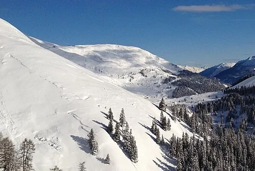
Schönjöchl HesedOla · CC BY 4.0

Climate of Zirmesköpfle
This month · November
A cold month
Day 0° · Night -6° · Rain 75 mm
- Hottest month
- July (day 14°)
- Coldest month
- January (night -10°)
- Wettest month
- July (123 mm)
- Driest month
- February (59 mm)
Bars: average monthly low and high temperature. Below: precipitation. Monthly averages for 1970–2000 at about 18 km resolution, adjusted for elevation. Highlighted months are mild and relatively dry. Source: WorldClim 2.1 (CC BY 4.0).
Show values as a table
| Month | Jan | Feb | Mar | Apr | May | Jun | Jul | Aug | Sep | Oct | Nov | Dec |
|---|---|---|---|---|---|---|---|---|---|---|---|---|
| Average high (°C) | -3° | -3° | 0° | 3° | 8° | 11° | 14° | 14° | 10° | 6° | 0° | -2° |
| Average low (°C) | -10° | -10° | -8° | -5° | 0° | 3° | 5° | 5° | 3° | -1° | -6° | -8° |
| Precipitation (mm) | 64 | 59 | 72 | 77 | 91 | 114 | 123 | 114 | 83 | 69 | 75 | 71 |
How to get to Zirmesköpfle
The nearest airport is Innsbruck Airport (INN), 57 km to the northeast as the crow flies. The nearest large city is Innsbruck, 60 km to the northeast.
Airports
- Innsbruck Airport (INN) Innsbruck 57 kmnortheast
- Bolzano Airport (BZO) Bolzano (BZ) 80 kmsoutheast
- Sankt Gallen Altenrhein Airport (ACH) St. Gallen 99 kmnorthwest
Nearby large cities
- Innsbruck Population: 132.5K 60 kmnortheast
- Munich Population: 1.5M 140 kmnortheast
- Augsburg Population: 301.1K 150 kmnorth
- Winterthur Population: 111.8K 157 kmwest
- Ulm Population: 120.5K 161 kmnorth
Straight-line distances; road distances are longer. Airport data: OurAirports.
Day trips from Zirmesköpfle
Within 100 km: 238 historic and cultural sites, 5,638 natural sites, 1,094 lakes, rivers and coasts.
0–25 km339 places
- Kapfkopf Mountain 23 kmW
- Motta d'Alp Mountain 23 kmSW
- Piz Malmurainza Mountain 25 kmSW
- Motta Mundin Mountain 22 kmSW
25–60 km2,378 places
- Lai da Juata Lake 50 kmSW
- Lai Sura Lake 54 kmSW
- Lai Verd Lake 46 kmSW
- Lai da Costainas Lake 56 kmS
60–100 km4,253 places
- Bayerisches Oberland Mountain 87 kmNE
- Schloss Hirschberg am Haarsee Historic site 96 kmNE
- Spadalone Mountain 99 kmS
- Chaviolas Island 98 kmSW
Straight-line distances.
Nearest towns and villages
Nearby attractions & nature
Everything nearby-
Karlspitz Mountain, Ried im Oberinntal2 km SE
-
Roter Schroffen Mountain, Kaunertal2.8 km E
-
Kuppkarlespitz Mountain, Ried im Oberinntal3.5 km SE
-
Ochsenkopf Mountain, Fendels3.5 km NE
-
Mittagskopf Mountain, Fendels3.6 km NE
-
Kaunsertal Natural site, Tyrol4.2 km E
-
Matonkopf Mountain, Tösens4 km SW
-
Hohes Riff Mountain, Kaunertal5.2 km S
Sources & licences
Data last updated: