- Elevation
- 1,786 m
- above sea level
- Local time
- UTC+01:00
- Europe/Vienna · UTC+01:00
- Airports
- INN Innsbruck Airport32 km
- FMM Memmingen Allgau Airport90 km
About Jöchle
Jöchle is a mountain. Location: Obsteig, Politischer Bezirk Imst. Elevation: 1,786 m. The nearest airport is Innsbruck Airport (32 km). Nearby sights include Nisskogel and Wankspitze.
Climate of Jöchle
This month · November
A cold month
Day 2° · Night -5° · Rain 76 mm
- Hottest month
- July (day 16°)
- Coldest month
- January (night -9°)
- Wettest month
- July (144 mm)
- Driest month
- February (59 mm)
Bars: average monthly low and high temperature. Below: precipitation. Monthly averages for 1970–2000 at about 18 km resolution, adjusted for elevation. Highlighted months are mild and relatively dry. Source: WorldClim 2.1 (CC BY 4.0).
Show values as a table
| Month | Jan | Feb | Mar | Apr | May | Jun | Jul | Aug | Sep | Oct | Nov | Dec |
|---|---|---|---|---|---|---|---|---|---|---|---|---|
| Average high (°C) | -2° | -1° | 2° | 5° | 11° | 14° | 16° | 16° | 12° | 8° | 2° | -1° |
| Average low (°C) | -9° | -9° | -6° | -3° | 1° | 4° | 6° | 6° | 4° | 0° | -5° | -8° |
| Precipitation (mm) | 61 | 59 | 71 | 76 | 98 | 133 | 144 | 135 | 91 | 72 | 76 | 69 |
How to get to Jöchle
The nearest airport is Innsbruck Airport (INN), 32 km to the east as the crow flies. The nearest large city is Innsbruck, 36 km to the east.
Airports
- Innsbruck Airport (INN) Innsbruck 32 kmeast
- Memmingen Allgau Airport (FMM) Memmingen 90 kmnorthwest
- Bolzano Airport (BZO) Bolzano (BZ) 101 kmsouth
Nearby large cities
- Innsbruck Population: 132.5K 36 kmeast
- Munich Population: 1.5M 103 kmnortheast
- Augsburg Population: 301.1K 117 kmnorth
- Ulm Population: 120.5K 139 kmnorthwest
- Ingolstadt Population: 120.7K 165 kmnorth
Straight-line distances; road distances are longer. Airport data: OurAirports.
Nearest towns and villages
Nearby attractions & nature
Everything nearby-
Nisskogel Mountain, Obsteig1.2 km SW
-
Wankspitze Mountain, Obsteig1.8 km NE
-
Höllkopf Mountain, Obsteig2.2 km N
-
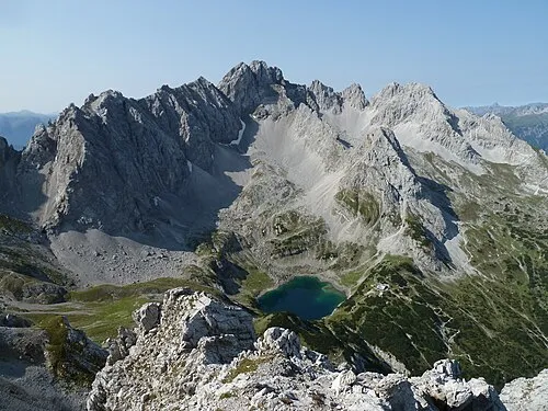 Grünstein Mountain, Obsteig3.1 km N
-
Marienberg Mountain, Obsteig3.1 km N
-
Gampenköpfle Mountain, Obsteig3.1 km W
-
Auf dem Horn Mountain, Obsteig4.3 km SW
-
Wamperter Schrofen Mountain, Biberwier3.6 km N
Sources & licences
Data last updated: