Panagía Evangelístria
Located in Nicosia Municipality, Nicosia Coordinates: 35°10′41″ N 33°22′29″ E
- Local time
- UTC+02:00
- Asia/Nicosia · UTC+02:00
- Elevation
- 138 m
- above sea level
- Airports
- ECN Ercan International Airport12 km
- LCA Larnaca International Airport41 km
About Panagía Evangelístria
Panagía Evangelístria is a tourist attraction. Location: Nicosia Municipality, Nicosia. The best months to visit are April, November. The nearest airport is Ercan International Airport (12 km). Nearby sights include Notre Dame de Tyre and Panagía.
Photos of Panagía Evangelístria
-
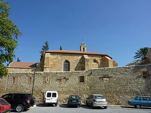
Notre Dame de Tyre Chris06 · CC BY-SA 4.0

Climate of Panagía Evangelístria
Best months for sightseeingBest months for sightseeing: April, November.
This month · November
A good month to visit
Day 23° · Night 11° · Rain 48 mm
- Hottest month
- August (day 36°)
- Coldest month
- February (night 6°)
- Wettest month
- December (82 mm)
- Driest month
- July (2 mm)
Bars: average monthly low and high temperature. Below: precipitation. Monthly averages for 1970–2000 at about 18 km resolution, adjusted for elevation. Highlighted months are mild and relatively dry. Source: WorldClim 2.1 (CC BY 4.0).
Show values as a table
| Month | Jan | Feb | Mar | Apr | May | Jun | Jul | Aug | Sep | Oct | Nov | Dec |
|---|---|---|---|---|---|---|---|---|---|---|---|---|
| Average high (°C) | 16° | 16° | 18° | 23° | 28° | 32° | 36° | 36° | 34° | 29° | 23° | 18° |
| Average low (°C) | 6° | 6° | 7° | 11° | 14° | 19° | 22° | 23° | 20° | 16° | 11° | 8° |
| Precipitation (mm) | 73 | 59 | 50 | 23 | 18 | 6 | 2 | 2 | 7 | 25 | 48 | 82 |
How to get to Panagía Evangelístria
The nearest airport is Ercan International Airport (ECN), 12 km to the east as the crow flies. The nearest large city is Nicosia, 2 km to the west.
Airports
- Ercan International Airport (ECN) Tymbou (Kirklar) 12 kmeast
- Larnaca International Airport (LCA) Larnaca 41 kmsoutheast
- Paphos International Airport (PFO) Paphos 96 kmsouthwest
Nearby large cities
- Nicosia Population: 200.5K 2 kmwest
- Limassol Population: 154K 63 kmsouthwest
- Silifke Population: 132.7K 142 kmnorth
- Alanya Population: 364.2K 196 kmnorthwest
- Mersin Population: 537.8K 214 kmnortheast
Straight-line distances; road distances are longer. Airport data: OurAirports.
Day trips from Panagía Evangelístria
Within 100 km: 1,388 historic and cultural sites, 582 natural sites, 115 lakes, rivers and coasts.
0–25 km394 places
- Nisída Kalamoúlia Island 23 kmNW
- Nisída Chotí Island 25 kmNE
- Nisída Glykiótissa Island 20 kmN
- Dolunay Göleti Lake 18 kmN
25–60 km940 places
- Mount Olympus Mountain 54 kmSW
- Cyprus Island 40 kmSW
- Stavrovoúni Attraction 33 kmS
- Governor’s Beach Beach 52 kmS
60–100 km751 places
- Tsada Community Park Natural site 90 kmSW
- Asprovounaro Mountain 90 kmSW
- Tala (Kamares Tennis Courts) Landmark 93 kmSW
- Toxéftra Beach Beach 100 kmW
Straight-line distances.
Nearby attractions & nature
Everything nearby-
Notre Dame de Tyre Attraction, Nicosia Municipality1.5 km W
-
Panagía Attraction, Nicosia Municipality0.5 km SE
-
Tahtakale Camii Attraction, Nicosia Municipality0.7 km SW
-
Haydarpaşa Camii Attraction, Nicosia Municipality0.8 km W
-
Byzantine Museum Museum, Nicosia Municipality0.9 km SW
-
Lapidere Müzesi Museum, Nicosia Municipality0.9 km W
-
Yeni Cami Attraction, Nicosia Municipality0.9 km W
-
Orthodox Cathedral of Panagia Hodegetria / Bedesten Historic site, Nicosia Municipality1 km W
Nearest towns and villages
-
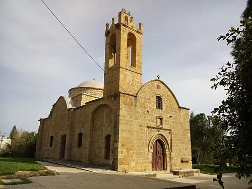 Ayios Dhometios Town, Ágios Dométios3.2 km W
-
 Taktelkale Neighbourhood, Nicosia Municipality0.3 km SW
-
 Kaimakli Neighbourhood, Nicosia Municipality1.2 km NE
-
Chrysaliniotissa Neighbourhood, Nicosia Municipality0.4 km W
Sources & licences
Data last updated: