Workerszell
Located in Schernfeld, Landkreis Eichstätt Coordinates: 48°55′40″ N 11°09′02″ E
- Population
- 326
- 326
- Elevation
- 541 m
- above sea level
- Local time
- UTC+01:00
- Europe/Berlin · UTC+01:00
About Workerszell
Workerszell is a village. Location: Schernfeld, Landkreis Eichstätt. Population: 326. Elevation: 541 m.
Workerszell is a village in the municipality of Schernfeld north of Eichstätt in Bavaria, Germany, stretching alongside the B 13 road, situated in the Franconian Jura. Up until its incorporation to Schernfeld in 1978, Workerszell forms with the districts Rupertsbuch, Geländer, Petershöhe (dissolved), Lohrmannshof, Sperberslohe and Langensallach an independent municipality. Workerszell's economy was traditionally based on farming and quarrying.
Read more on Wikipedia Text: Wikipedia contributors · CC BY-SA 4.0 · shortened
In comparison
- Nearest larger town: Eichstätt, 4 km SE
- 30 sights and natural places within 10 km Willibaldsburg, Jura-Museum Eichstätt
Nearby attractions & nature
Everything nearby-
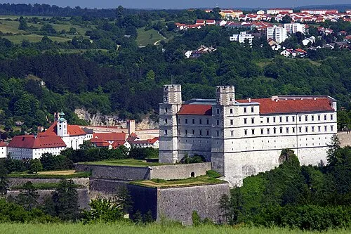 Willibaldsburg Historic site, Eichstätt3.9 km S
-
Jura-Museum Eichstätt Museum, Eichstätt3.9 km S
-
Willibaldsberg Castle Historic site, Eichstätt3.9 km S
-
Museum für Ur- und Frühgeschichte Eichstätt Museum, Eichstätt4 km S
-
Eichstätt Concentration Camp Historic site, Eichstätt4 km S
-
Workerszeller Forst Natural site, Bavaria4 km NW
Sources & licences
Data last updated: · 2 independent sources