Andvorza Harabesi
Located in Kozan, Adana Province Coordinates: 37°15′00″ N 35°53′00″ E
- Local time
- UTC+03:00
- Europe/Istanbul · UTC+03:00
- Elevation
- 32 m
- above sea level
- Airports
- COV Çukurova International Airport82 km
- KCM Kahramanmaraş Airport100 km
About Andvorza Harabesi
Andvorza Harabesi is a historic site. Location: Kozan, Adana Province.
Anazarbus, also known as Justinopolis (Ancient Greek: Ἀναζαρβός / Ἰουστινούπολις, medieval Ain Zarba; modern Anavarza; Arabic: عَيْنُ زَرْبَة), was an ancient Cilician city. Under the late Roman Empire, it was the capital of Cilicia Secunda. Roman emperor Justinian I rebuilt the city in 527 after a strong earthquake hit it. It was destroyed in 1374 by the forces of the Mamluk Empire, after their conquest of Cilician Armenia.
Source: Wikipedia · CC BY-SA 4.0
At a glance
- Heritage designation
- Tentative World Heritage Site
Source: Wikidata
Photos of Andvorza Harabesi
-
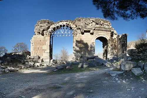
Anazarbus MUSTAFA TOR at English Wikipedia · CC BY-SA 3.0

Climate of Andvorza Harabesi
Best months for sightseeingBest months for sightseeing: March–April, November.
This month · November
A good month to visit
Day 22° · Night 11° · Rain 71 mm
- Hottest month
- July (day 35°)
- Coldest month
- January (night 5°)
- Wettest month
- December (121 mm)
- Driest month
- August (13 mm)
Bars: average monthly low and high temperature. Below: precipitation. Monthly averages for 1970–2000 at about 18 km resolution, adjusted for elevation. Highlighted months are mild and relatively dry. Source: WorldClim 2.1 (CC BY 4.0).
Show values as a table
| Month | Jan | Feb | Mar | Apr | May | Jun | Jul | Aug | Sep | Oct | Nov | Dec |
|---|---|---|---|---|---|---|---|---|---|---|---|---|
| Average high (°C) | 15° | 16° | 20° | 24° | 28° | 32° | 35° | 35° | 33° | 29° | 22° | 17° |
| Average low (°C) | 5° | 7° | 9° | 12° | 16° | 20° | 23° | 23° | 20° | 16° | 11° | 7° |
| Precipitation (mm) | 107 | 90 | 90 | 81 | 66 | 34 | 14 | 13 | 23 | 61 | 71 | 121 |
How to get to Andvorza Harabesi
The nearest airport is Çukurova International Airport (COV), 82 km to the southwest as the crow flies. The nearest large city is Osmaniye, 38 km to the southeast.
Airports
- Çukurova International Airport (COV) Tarsus 82 kmsouthwest
- Kahramanmaraş Airport (KCM) Kahramanmaraş 100 kmeast
- Hatay Airport (HTY) Antakya 105 kmsouth
Nearby large cities
- Osmaniye Population: 202.8K 38 kmsoutheast
- Adana Population: 1.8M 58 kmsouthwest
- İskenderun Population: 251.7K 78 kmsouth
- Arsuz Population: 109.6K 93 kmsouth
- Tarsus Population: 350.7K 95 kmsouthwest
Straight-line distances; road distances are longer. Airport data: OurAirports.
Day trips from Andvorza Harabesi
Within 100 km: 34 historic and cultural sites, 438 natural sites, 254 lakes, rivers and coasts.
0–25 km27 places
- Gökçe Dağ Mountain 20 kmE
- Hanyeri Tepesi Mountain 16 kmN
- Anavarza Tepesi Mountain 3 kmSE
- Ada Tepesi Mountain 25 kmS
25–60 km162 places
- Karatepe Aslantaşı Milli Parkı Natural site 33 kmE
- Yağızlar Göleti Lake 30 kmW
- Arıklıkaş Göleti Lake 57 kmE
- Seyhan Barajı Lake 54 kmW
60–100 km537 places
- Küçük Ada Island 86 kmSW
- Nergizi Adasi Island 78 kmSW
- Ömer Gölü Island 62 kmS
- Yapı Gölü Lake 66 kmSW
Straight-line distances.
Nearby attractions & nature
Everything nearby-
Anazarbus Historic site, Kozan2 km E
-
Anavarza Kalesi Historic site, Kozan1.8 km E
-
Anavarza Tepesi Mountain, Ceyhan2.6 km SE
-
Sumbas Çayı River, Adana Province5 km NE
-
Susas Çayı River, Adana Province5.7 km S
-
Deliçay Deresi River, Adana Province6.5 km N
-
Gürcüoğlu Kanalı River, Adana Province7.1 km S
-
Koca Dere River, Adana Province7.1 km SW
Nearest towns and villages

Sources & licences
Data last updated: · 2 independent sources