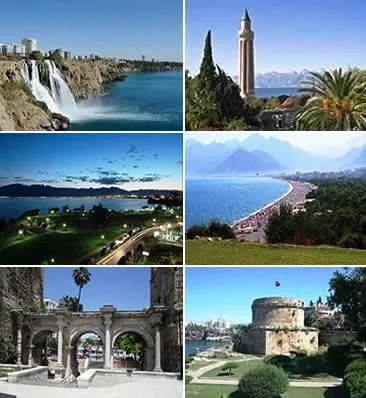
- Population
- 1,335,002
- 1.3M
- Elevation
- 61 m
- above sea level
- Local time
- UTC+03:00
- Europe/Istanbul · UTC+03:00
- Airports
- AYT Antalya International Airport9 km
- ISE Süleyman Demirel International Airport109 km
About Antalya
Antalya is a city. Location: Antalya Province, Turkey. Population: 1,335,002. Elevation: 61 m. The best months to visit are April, October. The nearest airport is Antalya International Airport (9 km). Nearby sights include Tophane Parkı and Alaadin Camii.
Photos of Antalya
-

Ray Swi-hymn from Sijhih-Taipei, Taiwan · CC BY-SA 2.0 -

More pics than views… · CC BY 3.0 -

Guus Gorter · CC BY-SA 4.0 -

Photon2297 · CC BY-SA 4.0 -

Arif miletli · CC BY-SA 4.0


Travel notes for Antalya
From Wikivoyage
Not to be confused with Alanya, a resort 130 km further east, or with Antakya a historic city in Hatay province of eastern Turkey.
Antalya is a city in Pamphylia on the Turkish Mediterranean coast, and the chief resort of the "Turkish Riviera". It's a metropolis with a population of 2.7 million in 2022, the fifth largest city in the country.
Understand+
The city was named after its first documented ruler Attalos II (220-138 BC), king of Pergamon, though it was obviously settled much earlier. Attalos' life and wife resembles soap opera, and his epiphet Philadelphos - "brother-loving" - hints at insecurity over how his relationship with back-from-the-dead brother and co-ruler Eumenes II might be portrayed. He based his fleet here - there were few alternatives along this exposed coast, and Attaleia (Ἀττάλεια) grew up around what's now called the Roman harbour. It never grew large as it lacked a hinterland - it's hemmed in by mountains with difficult routes to get inland, although a fertile coastal plain extends up to the east. Early visitors included St Paul the Apostle (Acts 14: 25-26) and Ibn Battuta, who in 1331 AD recorded how Christians, Greeks, Jews, and royal court each inhabited their own walled enclave, while the Muslims lived in the main body of town all within an enclosing wall.
This relative isolation meant little fighting here, but Antalya was the prize to be handed over after conquests elsewhere: to the Seljuks in 1207 and the Ottomans in 1391. After Turkey's defeat in World War I, the harsh 1920 Treaty of Sèvres handed over tracts of the country to the Allies, and Italy gained Antalya. This was reversed, and Turkey gained its present borders, by the 1923 Treaty of Lausanne.
Access was improved by road building in the 20th century, but the game-changer was in the 1970s when commercial airliners could jet tourists non-stop from northern Europe, and the political environment boosted tourist infrastructure. The city burgeoned, with development either side of Kaleiçi the old town centre, but especially east along the sandy Lara beach. Effectively this strip extends 150 km until the mountains terminate the coastal plain: it's all called "Antalya area" in tourist literature, but in this guide the easterly towns of Belek, Manavgat, Side and Alanya are described separately.
Get in+
By plane:
1 Antalya Airport (Antalya Havalimanı, AYT IATA). Flights from all over Europe and Russia bring hordes of tourists, mostly on package deals. Other destinations include Erjan, Amman, Beirut, Tel Aviv, Baghdad and the Gulf States. There are daily domestic flights from Istanbul (IST and SAW), Ankara, Izmir, Adana, Samsun, Diyarbakir and Gaziantep. The two terminals are 1.6 km apart with a free shuttle or walkway in between. T1 handles all domestic flights, and T2 international one. The airport has the standard facilities and is usually slick, but when flights are delayed the passengers back up and it gets chaotic. There are no drinking water taps inside the terminals. (updated Apr 2026)
Getting there and away:
Tram and bus can be paid contactless with credit card (about €1 per ride) or the AntalyaKart. The latter allows for certain discounts when used more often, interchange and for some attractions.
By tram – AntRay Tram 1A runs downtown from two T1 stops (domestic and international) every 15 min 06:00-00:00; it doesn't serve T2. Get off at İsmetpaşa (taking 50 min) for the old town or to transfer to Tram 2. Stay aboard another 30 min for Otogar the bus station. Coming out to the airport take Tram 1A badged "Havalimanı". Tram 1B follows the same route until Yonca Kavşak then branches off to Expo.
By bus – Route 600 runs from T1 (domestic) and T2 to Otogar - so this could serve as an inter-terminal shuttle and spare you a taxi. It runs every 30 min 07:00 to 00:00 with night runs (as Route 600G) around 01:00, 03:00 and 05:00. It runs via Mevlana Cd and Adnan Menderes Blv, taking about an hour to Otogar. At T1 the stop is by the blue "D" sign next to a fig tree, usually with a scrummage of other waiting passengers. Ignore the "D" outside T1 (international), which stands for "decoy" or "dupe me". Taxi touts will converge on you, saying truthfully "No bus leaving here!" and steering you towards a taxi.
Source: Wikivoyage · CC BY-SA 4.0 · abridged
Climate of Antalya
Best months for sightseeingBest months for sightseeing: April, October.
This month · November
Outside the best season
Day 20° · Night 7° · Rain 97 mm
Better nearby cities in November
- Alanya · 123 km east21°
- Aydin · 273 km northwest19°
- Silifke · 295 km east21°
- Hottest month
- July (day 36°)
- Coldest month
- January (night 3°)
- Wettest month
- December (144 mm)
- Driest month
- July (9 mm)
Bars: average monthly low and high temperature. Below: precipitation. Monthly averages for 1970–2000 at about 18 km resolution, adjusted for elevation. Highlighted months are mild and relatively dry. Source: WorldClim 2.1 (CC BY 4.0).
Show values as a table
| Month | Jan | Feb | Mar | Apr | May | Jun | Jul | Aug | Sep | Oct | Nov | Dec |
|---|---|---|---|---|---|---|---|---|---|---|---|---|
| Average high (°C) | 13° | 15° | 18° | 22° | 27° | 33° | 36° | 36° | 32° | 26° | 20° | 15° |
| Average low (°C) | 3° | 4° | 6° | 10° | 14° | 18° | 21° | 21° | 17° | 12° | 7° | 4° |
| Precipitation (mm) | 135 | 109 | 71 | 44 | 34 | 17 | 9 | 11 | 13 | 57 | 97 | 144 |
How to get to Antalya
The nearest airport is Antalya International Airport (AYT), 9 km to the east as the crow flies. The nearest large city is Muratpaşa, 6 km to the east.
Airports
- Antalya International Airport (AYT) Antalya 9 kmeast
- Süleyman Demirel International Airport (ISE) Isparta 109 kmnorth
- Çardak Airport (DNZ) Denizli 131 kmnorthwest
Nearby large cities
- Muratpaşa Population: 450K 6 kmeast
- Isparta Population: 172.3K 96 kmnorth
- Alanya Population: 364.2K 123 kmeast
- Denizli Population: 313.2K 172 kmnorthwest
- Merkezefendi Population: 280.3K 177 kmnorthwest
Straight-line distances; road distances are longer. Airport data: OurAirports.
Day trips from Antalya
Within 100 km: 83 historic and cultural sites, 1,156 natural sites, 244 lakes, rivers and coasts.
0–25 km171 places
- Konyaaltı Plajı Beach 7 kmSW
- Bambus Plajı Beach 5 kmSE
- Kumköy Plajı Beach 22 kmE
- Özlü Plajı Beach 21 kmE
25–60 km373 places
- Üçadalar Island 51 kmS
- Pozan Gölü Lake 43 kmW
- Ekşili Barajı Lake 28 kmN
- Koca Gölü Lake 43 kmE
60–100 km939 places
- Çenger Mevki, Side, Manavgat/Antalya Beach 86 kmE
- İncekum Beach 99 kmE
- Suluada Island 77 kmS
- Güvercin Adası Island 87 kmSW
Straight-line distances.
Antalya and similar cities
Side by side with cities of similar size in the same country: population, elevation and climate.
| Measure | Antalya | Konya | Kayseri | Esenyurt |
|---|---|---|---|---|
| Population | 1.3M | 1.4M | 1.5M | 983.6K |
| Elevation | 61 m | 1,030 m | 1,054 m | 97 m |
| Summer day (hottest month) | 36° | 30° | 30° | 28° |
| Winter night (coldest month) | 3° | -4° | -6° | 3° |
| Annual rainfall | 741 mm | 471 mm | 385 mm | 701 mm |
| Best months | Apr, Oct | May–Jun, Sep–Oct | May–Jun, Sep–Oct | May–Oct |
| Distance | — | 191 km | 468 km | 490 km |
Climate values are 1970–2000 monthly averages; straight-line distance.
Nearby attractions & nature
Everything nearby-
Tophane Parkı Natural site, Muratpaşa İlçesi2.5 km S
-
Alaadin Camii Attraction, Muratpaşa İlçesi2.5 km S
-
Paşa Camii Attraction, Muratpaşa İlçesi2.6 km S
-
Ahi Yusuf Mescidi Attraction, Muratpaşa İlçesi2.7 km S
-
Antalya Kalesi Historic site, Muratpaşa İlçesi2.8 km S
-
Hadrian Kale Kapısı Historic site, Muratpaşa İlçesi2.8 km SE
-
Antalya Müzesi Museum, Muratpaşa İlçesi2.8 km SW
-
Kuğulu Parkı Natural site, Muratpaşa İlçesi2.9 km SW
Sources & licences
Data last updated: