- Population
- 84,163
- 84.2K
- Elevation
- 1,663 m
- above sea level
- Local time
- UTC+03:00
- Europe/Istanbul · UTC+03:00
- Places inside
- 121
- listed under Tatvan İlçesi
- Airports
- MSR Muş Airport61 km
- VAN Van Ferit Melen Airport91 km
About Tatvan İlçesi
Tatvan İlçesi is a district. Location: Bitlis Province, Turkey. Population: 84,163. The best months to visit are June, September. The nearest airport is Muş Airport (61 km). Nearby sights include Korandar Deresi and Güzel Dere.
Climate of Tatvan İlçesi
Best months for sightseeingBest months for sightseeing: June, September.
This month · November
A wet month
Day 10° · Night 2° · Rain 108 mm
Better nearby cities in November
- Cizre · 130 km south20°
- Silopi · 140 km south20°
- Kızıltepe · 209 km southwest19°
- Hottest month
- August (day 29°)
- Coldest month
- January (night -5°)
- Wettest month
- April (129 mm)
- Driest month
- July (7 mm)
Bars: average monthly low and high temperature. Below: precipitation. Monthly averages for 1970–2000 at about 18 km resolution, adjusted for elevation. Highlighted months are mild and relatively dry. Source: WorldClim 2.1 (CC BY 4.0).
Show values as a table
| Month | Jan | Feb | Mar | Apr | May | Jun | Jul | Aug | Sep | Oct | Nov | Dec |
|---|---|---|---|---|---|---|---|---|---|---|---|---|
| Average high (°C) | 2° | 3° | 6° | 12° | 18° | 24° | 29° | 29° | 25° | 17° | 10° | 4° |
| Average low (°C) | -5° | -4° | -1° | 4° | 8° | 12° | 16° | 16° | 12° | 7° | 2° | -2° |
| Precipitation (mm) | 88 | 104 | 110 | 129 | 86 | 26 | 7 | 7 | 14 | 82 | 108 | 98 |
How to get to Tatvan İlçesi
The nearest airport is Muş Airport (MSR), 61 km to the northwest as the crow flies. The nearest large city is Siirt, 70 km to the southwest.
Airports
- Muş Airport (MSR) Muş 61 kmnorthwest
- Van Ferit Melen Airport (VAN) Van 91 kmeast
- Batman Airport (BAL) Batman 120 kmsouthwest
Nearby large cities
- Siirt Population: 114K 70 kmsouthwest
- Van Population: 525K 96 kmeast
- Batman Population: 452.2K 122 kmsouthwest
- Cizre Population: 134K 130 kmsouth
- Silopi Population: 114.6K 140 kmsouth
Straight-line distances; road distances are longer. Airport data: OurAirports.
Day trips from Tatvan İlçesi
Within 100 km: 88 historic and cultural sites, 691 natural sites, 338 lakes, rivers and coasts.
0–25 km48 places
- Lake Nemrut Lake 15 kmN
- Ziyaret Tepesi Mountain 18 kmSE
- Nemrut Dağı Mountain 18 kmN
- Kurulaval Dağı Mountain 8 kmNW
25–60 km216 places
- Avdu Adaları Island 57 kmE
- Simhaç Adası Island 32 kmE
- Şahur Adası Island 46 kmE
- Lake Van Lake 56 kmE
60–100 km853 places
- Demirkaya Historic site 82 kmSW
- İçeriçarpanak Adası Island 71 kmE
- Akdamar Adası Island 68 kmE
- Kuzu Adası Island 64 kmE
Straight-line distances.
Places in Tatvan İlçesi
121 places- 1 Tatvan 73.2K
- 2 Pınarbaşı 3.1K
- 3 Çağlayan Mahallesi 763
- 4 Alacabük 691
- 5 Çanakdüzü 580
- 6 Göllü 570
- 7 Reşadiye 570
- 8 Yumurtatepe 502
- 9 Dalda 398
- 10 Çekmece 376
- 11 Bolalan 362
- 12 Budaklı 265
- 13 Koruklu 247
- 14 Tokaçlı 246
- 15 Köprücek 222
- 16 Kolbaşı 218
- 17 Kuruyaka 209
- 18 Tosunlu 207
- 19 Yassıca 204
- 20 Örenlik 175
- 21 Düzcealan 173
- 22 Dibekli 159
- 23 Güntepe 135
- 24 Harmanlı 101
- 25 Yediveren 96
- 26 Uncular 91
- 27 Ulusoy 81
- 28 Kaynarca 68
- 29 Aksoğan 65
- 30 Uslu 62
Bar: population relative to the most populous place in this list.
Cities & villages24
- Aktoprak · Village
- Alan · Village
- Anadere · Village
- Arılı · Village
- Bağmese · Village
- Benekli · Village
- Beştaş · Village
- Çalıdüzü · Village
- Camaltı · Village
- Çataltepe · Village
- Çavuşlar · Village
- Çayırönü · Village
- Çevreköy · Village
- Dağdibi · Village
- Değirmenbaşı · Village
- Dirlik · Village
- Doluca · Village
- Dönertaş · Village
- Eğritaş · Village
- Emek · Village
- Eskitatvan · Village
- Güreşçi · Village
- Güvenli · Village
- Hanelmalı · Village
Mountains & nature5
- Bal Dağı · Mountain
- Cemin Dağı · Mountain
- Divrik Tepesi · Mountain
- Gökgören Dağı · Mountain
- Hap Dağı · Mountain
Heritage & sights1
- Direkli · Historic site
Nearby attractions & nature
Everything nearby-
Korandar Deresi River, Bitlis Province2.6 km SE
-
Güzel Dere River, Bitlis Province5 km S
-
Geli Deresi River, Bitlis Province7.6 km SE
-
Ortaklar Deresi River, Bitlis Province8 km S
-
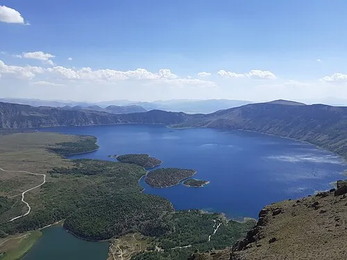 Nemrut Caldera Natural site, Bitlis Province16 km N
-
Kurt Burnu Natural site, Van Province8.3 km NE
Sources & licences
Data last updated: