- Elevation
- 2,024 m
- above sea level
- Local time
- UTC+02:00
- Europe/Bucharest · UTC+02:00
- Airports
- GHV Brașov-Ghimbav International Airport28 km
- SBZ Sibiu International Airport94 km
About Padina Popii
Padina Popii is a mountain. Location: Oraş Zãrneşti, Brașov County. Elevation: 2,024 m. The nearest airport is Brașov-Ghimbav International Airport (28 km). Nearby sights include Padinii Inchise and Turnu.
Photos of Padina Popii
-
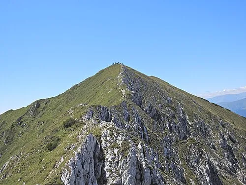
La Om Xulescu g · CC BY-SA 4.0 -
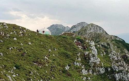
Ascutit Petr Vodička · CC BY-SA 4.0


Climate of Padina Popii
This month · November
A cold month
Day -2° · Night -10° · Rain 35 mm
- Hottest month
- August (day 13°)
- Coldest month
- January (night -16°)
- Wettest month
- June (104 mm)
- Driest month
- February (30 mm)
Bars: average monthly low and high temperature. Below: precipitation. Monthly averages for 1970–2000 at about 18 km resolution, adjusted for elevation. Highlighted months are mild and relatively dry. Source: WorldClim 2.1 (CC BY 4.0).
Show values as a table
| Month | Jan | Feb | Mar | Apr | May | Jun | Jul | Aug | Sep | Oct | Nov | Dec |
|---|---|---|---|---|---|---|---|---|---|---|---|---|
| Average high (°C) | -7° | -6° | -2° | 3° | 8° | 11° | 13° | 13° | 9° | 5° | -2° | -6° |
| Average low (°C) | -16° | -15° | -11° | -6° | -2° | 2° | 3° | 2° | -1° | -6° | -10° | -14° |
| Precipitation (mm) | 31 | 30 | 35 | 57 | 84 | 104 | 100 | 82 | 52 | 40 | 35 | 34 |
How to get to Padina Popii
The nearest airport is Brașov-Ghimbav International Airport (GHV), 28 km to the northeast as the crow flies. The nearest large city is Brasov, 30 km to the east.
Airports
- Brașov-Ghimbav International Airport (GHV) Brașov (Ghimbav) 28 kmnortheast
- Sibiu International Airport (SBZ) Sibiu 94 kmwest
- Târgu Mureş Transilvania International Airport (TGM) Recea 120 kmnorthwest
Nearby large cities
- Brasov Population: 253.2K 30 kmeast
- Piteşti Population: 141.3K 83 kmsouth
- Sibiu Population: 134.3K 89 kmwest
- Ploieşti Population: 180.5K 90 kmsoutheast
- Târgu Mureş Population: 212.8K 122 kmnorthwest
Straight-line distances; road distances are longer. Airport data: OurAirports.
Day trips from Padina Popii
Within 100 km: 1 historic or cultural site, 769 natural sites, 1 lake, river or coast.
0–25 km207 places
- Masiv Postăvarul Mountain 24 kmE
- Vârful Sigluia Mountain 19 kmS
- Papusa Mountain 15 kmW
- Omu Mountain 21 kmSE
25–60 km371 places
- Coltii Blajeni Mountain 31 kmS
- Puha Mountain 57 kmW
- Horezu Mountain 37 kmN
- Bodos Mountain 51 kmNE
60–100 km193 places
- Valea Râul Sadului Natural site 87 kmW
- Valea Râncăciov Natural site 69 kmS
- Valea Rea Natural site 88 kmE
- Valea Purcăreanca Natural site 71 kmSW
Straight-line distances.
Nearest towns and villages
-
Zarnesti City, Oraş Zãrneşti6 km E
-
Măgura Village, Comuna Moieciu5.1 km SE
-
Peștera Village, Comuna Moieciu5.8 km SE
-
Poiana Mărului City, Comuna Poiana Mărului6.9 km NE
-
Moeciu de Jos Village, Municipiul Braşov9.6 km SE
-
Bran City, Comuna Bran9.3 km SE
Nearby attractions & nature
Everything nearby-
Padinii Inchise Mountain, Comuna Moieciu0.3 km NE
-
Turnu Mountain, Oraş Zãrneşti0.9 km NE
-
Ascutit Mountain, Oraş Zãrneşti1.1 km SW
-
Varful Intre Timbale Mountain, Oraş Zãrneşti1.7 km SW
-
Coltul Chiliilor Mountain, Oraş Zãrneşti2 km N
-
Timbalul Mic Mountain, Oraş Zãrneşti2 km SW
-
Piatra Mica Mountain, Comuna Moieciu2.3 km E
-
Claia Vladuscai Mountain, Oraş Zãrneşti2.8 km SW
Sources & licences
Data last updated: · 2 independent sources