- Population
- 134,572
- 134.6K
- Elevation
- 1,331 m
- above sea level
- Local time
- UTC+01:00
- Europe/Madrid · UTC+01:00
- Places inside
- 236
- listed under Province of Teruel
- Airports
- CDT Castellón-Costa Azahar Airport80 km
- ZAZ Zaragoza Airport115 km
About Province of Teruel
Province of Teruel is a district. Location: Aragon, Spain. Population: 134,572. The best months to visit are June, September. The nearest airport is Castellón-Costa Azahar Airport (80 km).
Photos of Province of Teruel
-
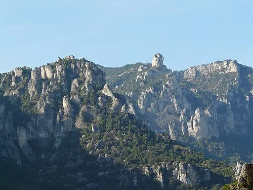
Corullons Pere prlpz · CC BY-SA 3.0 -
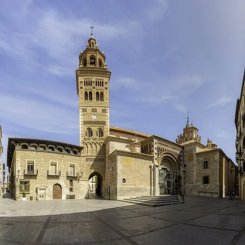
Teruel Cathedral Fernando · CC BY-SA 4.0 -
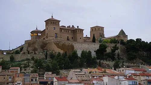
Castle Calatravo Jome · CC BY-SA 3.0 es


Climate of Province of Teruel
Best months for sightseeingBest months for sightseeing: June, September.
This month · November
A cold month
Day 10° · Night -2° · Rain 31 mm
Better nearby cities in November
- Alicante · 259 km south20°
- Elche · 267 km south20°
- Orihuela · 288 km south20°
- Hottest month
- July (day 28°)
- Coldest month
- January (night -5°)
- Wettest month
- May (75 mm)
- Driest month
- February (24 mm)
Bars: average monthly low and high temperature. Below: precipitation. Monthly averages for 1970–2000 at about 18 km resolution, adjusted for elevation. Highlighted months are mild and relatively dry. Source: WorldClim 2.1 (CC BY 4.0).
Show values as a table
| Month | Jan | Feb | Mar | Apr | May | Jun | Jul | Aug | Sep | Oct | Nov | Dec |
|---|---|---|---|---|---|---|---|---|---|---|---|---|
| Average high (°C) | 6° | 9° | 12° | 13° | 18° | 23° | 28° | 28° | 23° | 16° | 10° | 7° |
| Average low (°C) | -5° | -4° | -2° | 0° | 4° | 7° | 10° | 10° | 6° | 3° | -2° | -3° |
| Precipitation (mm) | 27 | 24 | 30 | 49 | 75 | 58 | 34 | 37 | 45 | 46 | 31 | 35 |
How to get to Province of Teruel
The nearest airport is Castellón-Costa Azahar Airport (CDT), 80 km to the southeast as the crow flies. For international flights: Zaragoza Airport (ZAZ) (115 km). The nearest large city is Castellon, 92 km to the southeast.
Airports
- Castellón-Costa Azahar Airport (CDT) Castellón de la Plana 80 kmsoutheast
- Zaragoza Airport (ZAZ) Zaragoza 115 kmnorth
- Valencia Airport (VLC) Valencia 132 kmsouth
Nearby large cities
- Castellon Population: 183.7K 92 kmsoutheast
- Zaragoza Population: 687K 111 kmnorth
- Valencia Population: 824.3K 135 kmsouth
- Lleida Population: 140.8K 151 kmnortheast
- Reus Population: 103.5K 159 kmeast
Straight-line distances; road distances are longer. Airport data: OurAirports.
Day trips from Province of Teruel
Within 100 km: 106 historic and cultural sites, 162 natural sites, 139 lakes, rivers and coasts.
0–25 km22 places
- Laguna de La Encañizada Lake 2 kmS
- Sierra de San Just Mountain 16 kmNW
- Sierra de Gúdar Mountain 24 kmS
- Cerro del Trabinal Mountain 21 kmSE
25–60 km91 places
- Pantano de Santolea Lake 30 kmE
- Pantano de Moneva Lake 58 kmN
- La Estanca Lake 59 kmNE
- Balsa de la Higuera Lake 60 kmN
60–100 km294 places
- Playa Roda Beach 95 kmSE
- Playa del Río Beach 99 kmE
- Playa del Moro Beach 93 kmSE
- Playa del Cargador Beach 93 kmSE
Straight-line distances.
Places in Province of Teruel
236 places- 121 Bellmunt de Mesquí / Belmonte de San José 126
- 122 Cuevas Labradas Municipality 126
- 123 Allepuz Municipality 123
- 124 Loscos Municipality 121
- 125 Torre del Compte Municipality 120
- 126 Pancrudo Municipality 118
- 127 Corbalán Municipality 117
- 128 Bordón Municipality 116
- 129 Torremocha de Jiloca Municipality 115
- 130 Torrecilla del Rebollar Municipality 114
- 131 Barrachina Municipality 113
- 132 Riodeva Municipality 113
- 133 Orrios Municipality 112
- 134 Los Olmos Municipality 111
- 135 Cañizar del Olivar Municipality 110
- 136 Mirambel Municipality 107
- 137 La Cañada de Verich Municipality 106
- 138 Arcos de las Salinas Municipality 105
- 139 Hinojosa de Jarque Municipality 104
- 140 Libros Municipality 102
- 141 El Pobo Municipality 97
- 142 Rillo Municipality 95
- 143 Azaila Municipality 94
- 144 Castelnou Municipality 94
- 145 Cascante del Río Municipality 91
- 146 Crivillén Municipality 91
- 147 Villahermosa del Campo Municipality 91
- 148 Fuentes Calientes Municipality 89
- 149 Peralejos Municipality 89
- 150 El Cuervo Municipality 88
- 151 Gargallo Municipality 88
- 152 Huesa del Común Municipality 86
- 153 Vivel del Río Martín Municipality 86
- 154 Camarillas Municipality 84
- 155 Mezquita de Jarque Municipality 83
- 156 Monforte de Moyuela Municipality 83
- 157 Aguilar del Alfambra Municipality 82
- 158 Valdelinares Municipality 82
- 159 Ferreruela de Huerva Municipality 81
- 160 Castel de Cabra Municipality 79
- 161 La Hoz de la Vieja Municipality 79
- 162 Cucalón Municipality 77
- 163 La Cerollera Municipality 77
- 164 Torre los Negros Municipality 77
- 165 Calomarde Municipality 76
- 166 Pozuel del Campo Municipality 76
- 167 Singra Municipality 76
- 168 Torre de Arcas Municipality 76
- 169 Blesa Municipality 74
- 170 Ababuj Municipality 73
- 171 Bezas Municipality 73
- 172 Gúdar Municipality 73
- 173 Cortes de Aragón Municipality 72
- 174 Fórnoles Municipality 71
- 175 Lagueruela Municipality 71
- 176 Peracense Municipality 68
- 177 Cabra de Mora Municipality 66
- 178 Jabaloyas Municipality 66
- 179 Jarque de la Val Municipality 66
- 180 Monterde de Albarracín Municipality 66
Bar: population relative to the most populous place in this list.
Nature and heritage in Province of Teruel
Sources & licences
Data last updated: