Cap de Boumort
Located in Conca de Dalt, Lleida Coordinates: 42°14′04″ N 1°08′03″ E
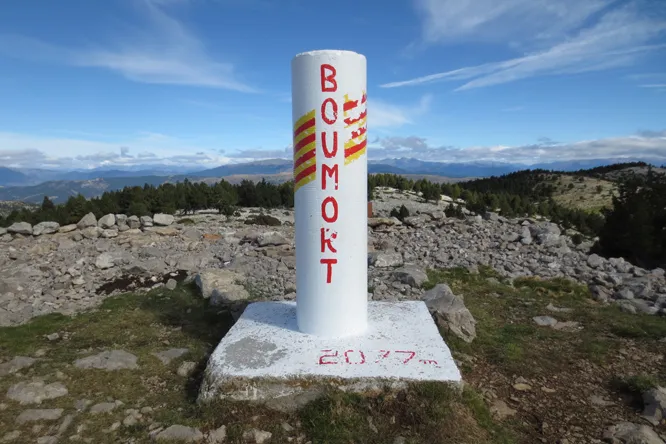
- Elevation
- 2,077 m
- above sea level
- Local time
- UTC+01:00
- Europe/Madrid · UTC+01:00
About Cap de Boumort
Cap de Boumort is a mountain. Location: Conca de Dalt, Lleida. Elevation: 2,077 m.
Cap de Boumort is a mountain of Catalonia, Spain. It has an elevation of 2,075 metres above sea level. It is the highest summit of the Serra de Boumort range in the Pre-Pyrenees.
Read more on Wikipedia Text: Wikipedia contributors · CC BY-SA 4.0 · shortened
At a glance
- Topographic prominence
- 653 m
Source: Wikidata
In comparison
- No. 723 of 3603 mountains in Spain by elevation
- 10 sights and natural places within 10 km Cap del Pou de Gel, Serra de Boumort
Nearest towns and villages
-
Abella de la Conca Municipality, Lleida7.2 km S
-
Abella de la Conca Village, Abella de la Conca8.8 km SW
-
Cabó Municipality, Lleida8.9 km E
-
Ortoneda Village, Conca de Dalt7.7 km W
-
Boixols Village, Abella de la Conca7.4 km S
-
la Pobla de Segur Municipality, Lleida13 km W
Nearby attractions & nature
Everything nearby-
Cap del Pou de Gel Mountain, Conca de Dalt0.8 km NE
-
Serra de Boumort Mountain, Conca de Dalt1 km W
-
Cap del Solà de la Coma d'Orient Mountain, Conca de Dalt3.1 km N
-
la Cogulla Mountain, Conca de Dalt4.5 km W
-
Cap de Carreu Mountain, Abella de la Conca4.6 km S
-
Roca de Senyús Mountain, Cabó4.6 km SE
-
Pical Ras Mountain, Abella de la Conca4.7 km S
-
Cap de Plan-de-Riba Mountain, Abella de la Conca5.2 km S
Sources & licences
Data last updated: · 2 independent sources