Castro Caldelas
Located in Ourense, Galicia Coordinates: 42°23′00″ N 7°24′43″ W
- Population
- 1,486
- 1.5K
- Elevation
- 590 m
- above sea level
- Local time
- UTC+01:00
- Europe/Madrid · UTC+01:00
- Places inside
- 26
- listed under Castro Caldelas
About Castro Caldelas
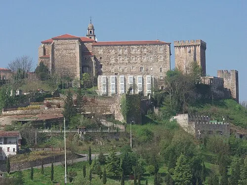
Castro Caldelas is a municipality. Location: Ourense, Galicia. Population: 1,486. Elevation: 590 m.
Castro Caldelas is a municipality in the province of Ourense, in the autonomous community of Galicia, Spain. It belongs to the comarca of Terra de Caldelas. Its area is 87,6 km2. Castro Caldelas is divided into 16 areas and 86 entities of population, with a population of 1,313 (INE 2016). Its residents are called caldelaos.
Read more on Wikipedia Text: Wikipedia contributors · CC BY-SA 4.0 · shortened
At a glance
- Area
- 87.6 km²
Source: Wikidata
In comparison
- No. 54 of 92 places in Ourense by population
- Nearest larger town: Lobios, 10 km W
- 9 sights and natural places within 10 km Regato de Ferreiros, Río Edo
- Listed here: Village: 21, River: 3, Attraction: 1, Mountain: 1
Places in Castro Caldelas
26 places-
Castro Caldelas Village1.2K
-
Alais Village6
-
Aguil Village
-
Camba Village
-
Castrelo Village
-
Folgoso Village
-
Mazaira Village
-
Mosteiro de San Paio de Abeleda Attraction
-
O Burgo Village
-
O Chaguacedo Village
-
O Val Village
-
Paradela Village
-
Pedrouzos Village
-
Poboeiros Village
-
Regato de Ferreiros River
-
Rego de Bans River
-
Río Edo River
-
Santa Tegra de Abeleda Village
-
Santo Village
-
Sás de Penelas Village
-
Sequeiros Village
-
Serra do Burgo Mountain
-
Trabazos Village
-
Tronceda Village
-
Villamayor Village
-
Vimieiro Village
Nearby attractions & nature
Everything nearby-
Regato Sanfitoiro River, Quiroga6.5 km E
-
Regato de San Xoan River, Ribas de Sil7.5 km N
-
Río Mao River, Parada de Sil7.6 km W
-
 Monasterio de San Vicente del Pino Attraction, Monforte de Lemos18 km NW
-
Río de Rabal River, Chandrexa de Queixa9.7 km S
-
Rairos railway bridge Landmark, Quiroga11 km NE
-
Río Lor River, Quiroga10 km NE
-
Rego de Castéligo River, Chandrexa de Queixa12 km S
Sources & licences
Data last updated: · 2 independent sources