Njåtsos Vagge
Located in Norrbotten County, Sweden Coordinates: 67°08′00″ N 17°31′00″ E
- Elevation
- 1,050 m
- above sea level
- Local time
- UTC+01:00
- Europe/Stockholm · UTC+01:00
- Airports
- BOO Bodø Airport137 km
- KRN Kiruna Airport143 km
About Njåtsos Vagge
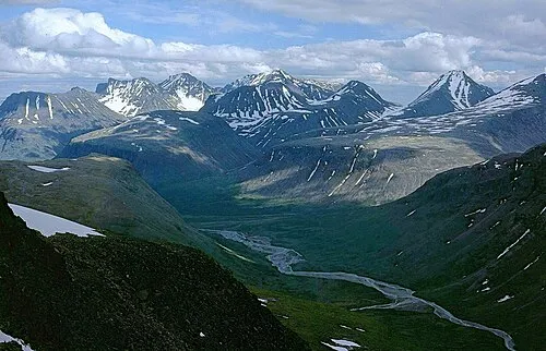
Njåtsos Vagge is a natural site. Location: Norrbotten County, Sweden. The nearest airport is Bodø Airport (137 km). Nearby sights include Luotoh and Ruonasvágge.
Climate of Njåtsos Vagge
This month · November
A cold month
Day -6° · Night -13° · Rain 50 mm
- Hottest month
- July (day 13°)
- Coldest month
- January (night -18°)
- Wettest month
- July (95 mm)
- Driest month
- April (35 mm)
Bars: average monthly low and high temperature. Below: precipitation. Monthly averages for 1970–2000 at about 18 km resolution, adjusted for elevation. Highlighted months are mild and relatively dry. Source: WorldClim 2.1 (CC BY 4.0).
Show values as a table
| Month | Jan | Feb | Mar | Apr | May | Jun | Jul | Aug | Sep | Oct | Nov | Dec |
|---|---|---|---|---|---|---|---|---|---|---|---|---|
| Average high (°C) | -10° | -9° | -6° | -1° | 4° | 10° | 13° | 11° | 5° | -1° | -6° | -9° |
| Average low (°C) | -18° | -18° | -15° | -10° | -4° | 1° | 5° | 3° | -1° | -6° | -13° | -17° |
| Precipitation (mm) | 51 | 42 | 41 | 35 | 40 | 60 | 95 | 73 | 59 | 56 | 50 | 49 |
How to get to Njåtsos Vagge
The nearest airport is Bodø Airport (BOO), 137 km to the west as the crow flies. The nearest large city is Umeå, 390 km to the south.
Airports
- Bodø Airport (BOO) Bodø 137 kmwest
- Kiruna Airport (KRN) Kiruna 143 kmnortheast
- Gällivare Airport (GEV) Gällivare 143 kmeast
Nearby large cities
- Umeå Population: 130.2K 390 kmsouth
Straight-line distances; road distances are longer. Airport data: OurAirports.
Day trips from Njåtsos Vagge
Within 100 km: 196 natural sites, 6 lakes, rivers and coasts.
0–25 km28 places
- Vuogá Mountain 25 kmS
- Vassjatjåkko Mountain 24 kmNE
- Vaikantjåkko Mountain 22 kmE
- Unna Rissavare Mountain 22 kmNW
25–60 km55 places
- Passåive Mountain 31 kmE
- Jiertasuoloi Island 52 kmNE
- Akkajaure Lake 57 kmN
- Vistáttjåhkkå Mountain 27 kmSE
60–100 km119 places
- Alepsuolo Island 84 kmS
- Petsesuolo Island 70 kmE
- Iehkálsuolo Island 86 kmSE
- Bierna Island 79 kmE
Straight-line distances.
Nearby attractions & nature
Everything nearby-
Luotoh Mountain, Jokkmokk Municipality6 km N
-
Ruonasvágge Natural site, Norrbotten County10 km SW
-
Luottolako Mountain, Jokkmokk Municipality11 km N
-
Kåtokjokotjkaskatjåkkå Mountain, Jokkmokk Municipality12 km NE
-
Skevvon Mountain, Jokkmokk Municipality12 km W
-
Nåite Mountain, Jokkmokk Municipality13 km N
-
Luotoh Mountain, Jokkmokk Municipality13 km N
-
Ruovddevárre Mountain, Jokkmokk Municipality10 km S
More nature in Sweden
-
 Sarvesvagge Natural site, Norrbotten County13 km N
-
Pårektjåkkå Mountain, Jokkmokk Municipality12 km E
-
Skaitefjäll Mountain, Jokkmokk Municipality14 km NE
-
Jägnakvagge Natural site, Norrbotten County14 km NE
-
Ritanjunjestjåkkå Mountain, Jokkmokk Municipality17 km N
-
Tarradalen Natural site, Norrbotten County15 km W
Sources & licences
Data last updated: · 2 independent sources