- Elevation
- 1,750 m
- above sea level
- Local time
- UTC+01:00
- Europe/Zurich · UTC+01:00
- Airports
- BRN Bern Airport21 km
- BSL EuroAirport Basel–Mulhouse–Freiburg97 km
About Selibüel
Selibüel is a mountain. Location: Rüschegg, Bern-Mittelland District. Elevation: 1,750 m.
The Selibüel is a mountain of the Bernese Alpine foothills, located in the municipality of Rüschegg in the canton of Bern. It is the culminating point of the wooded range that lies north of the Gurnigel Pass, between the valleys of the Sense (west) and the Aare (east). The summit area, as well as the other summits of the range, such as the Pfyffe, is easily accessible by car or by bus via the Gurnigel road.
Source: Wikipedia · CC BY-SA 4.0
At a glance
- Topographic prominence
- 170 m
Source: Wikidata
Photos of Selibüel
-
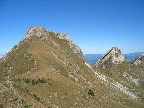
Gantrisch Patric Zbinden · Public domain

Climate of Selibüel
This month · November
A wet month
Day 2° · Night -5° · Rain 110 mm
- Hottest month
- July (day 16°)
- Coldest month
- January (night -8°)
- Wettest month
- June (128 mm)
- Driest month
- March (86 mm)
Bars: average monthly low and high temperature. Below: precipitation. Monthly averages for 1970–2000 at about 18 km resolution, adjusted for elevation. Highlighted months are mild and relatively dry. Source: WorldClim 2.1 (CC BY 4.0).
Show values as a table
| Month | Jan | Feb | Mar | Apr | May | Jun | Jul | Aug | Sep | Oct | Nov | Dec |
|---|---|---|---|---|---|---|---|---|---|---|---|---|
| Average high (°C) | -2° | -1° | 2° | 5° | 10° | 13° | 16° | 16° | 12° | 7° | 2° | -1° |
| Average low (°C) | -8° | -8° | -6° | -4° | 1° | 4° | 6° | 6° | 3° | 0° | -5° | -7° |
| Precipitation (mm) | 98 | 104 | 86 | 94 | 110 | 128 | 114 | 115 | 93 | 102 | 110 | 113 |
How to get to Selibüel
The nearest airport is Bern Airport (BRN), 21 km to the north as the crow flies. For international flights: EuroAirport Basel–Mulhouse–Freiburg (BSL) (97 km). The nearest large city is Bern, 24 km to the north.
Airports
- Bern Airport (BRN) Bern 21 kmnorth
- EuroAirport Basel–Mulhouse–Freiburg (BSL) Bâle / Mulhouse 97 kmnorth
- Geneva International Airport (GVA) Geneva 116 kmsouthwest
Nearby large cities
- Bern Population: 121.6K 24 kmnorth
- Lausanne Population: 139.1K 66 kmwest
- Basel Population: 177.6K 92 kmnorth
- Zurich Population: 415.4K 110 kmnortheast
- Mulhouse Population: 111.4K 114 kmnorth
Straight-line distances; road distances are longer. Airport data: OurAirports.
Day trips from Selibüel
Within 100 km: 246 historic and cultural sites, 5,316 natural sites, 758 lakes, rivers and coasts.
0–25 km342 places
- Lake Thun Lake 22 kmE
- Schwarzsee Lake 14 kmSW
- Gerzensee Lake 14 kmNE
- Amsoldingersee Lake 11 kmE
25–60 km1,840 places
- Kleiner Bremgartenwald Mountain 26 kmN
- Strandbad Neuhaus Beach 30 kmE
- Strandbad Manor Farm Beach 29 kmE
- Strandbad Leissigen Beach 27 kmE
60–100 km4,138 places
- Arbeiterstrandbad Tennwil Beach 87 kmNE
- Lago Nero Lake 90 kmE
- Insel Schwanau Island 94 kmE
- Sankt-Niklausen-Insle Island 78 kmNE
Straight-line distances.
Nearest towns and villages
-
Blumenstein Municipality, Thun District4.4 km E
-
Wattenwil Municipality, Thun District5.2 km NE
-
Schwefelbergbad Village, Rüschegg2.4 km SW
-
Riggisberg Municipality, Bern-Mittelland District5.9 km N
-
Rüschegg Village, Rüschegg6.5 km NW
-
Eywald Village, Rüschegg3.9 km NW
Nearby attractions & nature
Everything nearby-
Zigerhubel Mountain, Riggisberg1.8 km E
-
Gantrisch Mountain, Rüschegg3.1 km S
-
Schüpfeflue Mountain, Rüschegg2 km W
-
Ober Gurnigel Mountain, Riggisberg2.1 km NE
-
Luterbüel Mountain, Rüschegg2.2 km N
-
Birehubel Mountain, Rüschegg2.3 km S
-
Tschingelflue Mountain, Rüeggisberg2.3 km SE
-
Gantrischseeli Lake, Rüschegg2.2 km S
Sources & licences
Data last updated: · 2 independent sources