- Elevation
- 2,309 m
- above sea level
- Local time
- UTC+01:00
- Europe/Zurich · UTC+01:00
- Airports
- BRN Bern Airport69 km
- ZRH Zürich Airport76 km
About Rot Nollen
Rot Nollen is a mountain. Location: Wolfenschiessen, Nidwalden. Elevation: 2,309 m. The nearest airport is Bern Airport (69 km). Nearby sights include Schafberg and Ochsenhorn.
Photos of Rot Nollen
-
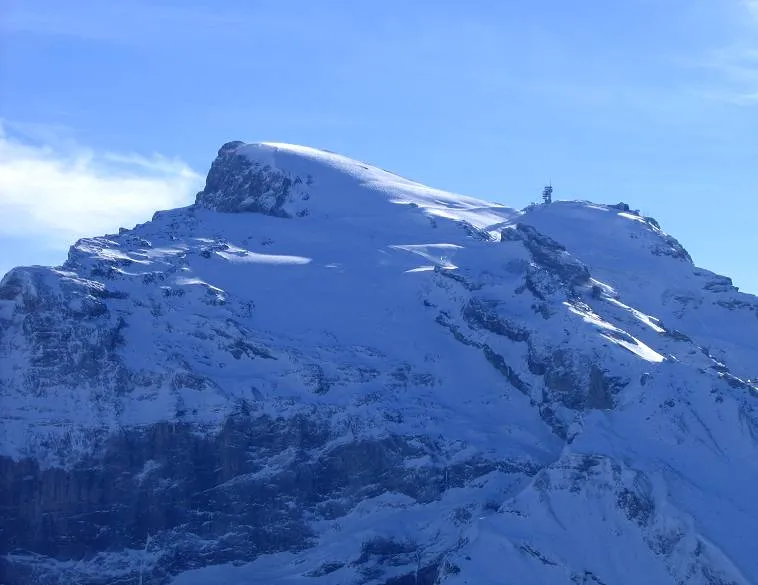
Titlis Mussklprozz · CC BY-SA 3.0

Climate of Rot Nollen
This month · November
A wet month
Day -1° · Night -6° · Rain 121 mm
- Hottest month
- August (day 11°)
- Coldest month
- February (night -10°)
- Wettest month
- July (144 mm)
- Driest month
- February (96 mm)
Bars: average monthly low and high temperature. Below: precipitation. Monthly averages for 1970–2000 at about 18 km resolution, adjusted for elevation. Highlighted months are mild and relatively dry. Source: WorldClim 2.1 (CC BY 4.0).
Show values as a table
| Month | Jan | Feb | Mar | Apr | May | Jun | Jul | Aug | Sep | Oct | Nov | Dec |
|---|---|---|---|---|---|---|---|---|---|---|---|---|
| Average high (°C) | -4° | -4° | -3° | -1° | 4° | 7° | 10° | 11° | 8° | 4° | -1° | -3° |
| Average low (°C) | -10° | -10° | -9° | -7° | -2° | 1° | 3° | 4° | 1° | -2° | -6° | -9° |
| Precipitation (mm) | 103 | 96 | 109 | 121 | 124 | 141 | 144 | 138 | 119 | 119 | 121 | 111 |
How to get to Rot Nollen
The nearest airport is Bern Airport (BRN), 69 km to the west as the crow flies. For international flights: Zürich Airport (ZRH) (76 km). The nearest large city is Zurich, 66 km to the north.
Airports
- Bern Airport (BRN) Bern 69 kmwest
- Zürich Airport (ZRH) Zurich 76 kmnorth
- Lugano Airport (LUG) Agno 95 kmsoutheast
Nearby large cities
- Zurich Population: 415.4K 66 kmnorth
- Bern Population: 121.6K 74 kmwest
- Winterthur Population: 111.8K 85 kmnorth
- Basel Population: 177.6K 106 kmnorthwest
- Mulhouse Population: 111.4K 134 kmnorthwest
Straight-line distances; road distances are longer. Airport data: OurAirports.
Day trips from Rot Nollen
Within 100 km: 271 historic and cultural sites, 6,679 natural sites, 982 lakes, rivers and coasts.
0–25 km1,075 places
- Neptun-Inseln Island 21 kmNE
- Lorelei-Inseln Island 21 kmNE
- Sarnersee Lake 16 kmNW
- Lungernsee Lake 17 kmW
25–60 km2,978 places
- Strandbad Neuhaus Beach 45 kmW
- Strandbad Manor Farm Beach 45 kmW
- Strandbad Leissigen Beach 49 kmW
- Strandbad Iseltwald Beach 32 kmW
60–100 km3,879 places
- Kleiner Bremgartenwald Mountain 75 kmW
- Fahr Abbey Attraction 70 kmN
- Sankt Petersinsel Island 100 kmW
- Isole di Brissago Island 77 kmS
Straight-line distances.
Nearest towns and villages
-
Ober Trübsee Alp Village, Wolfenschiessen2.2 km N
-
Engelberg Village, Engelberg4.7 km N
-
Engelberg Municipality, Obwalden5.9 km NE
-
Scharmadläger Village, Innertkirchen2.9 km SW
-
Kerns Municipality, Obwalden9 km NW
-
Tannen Village, Innertkirchen4 km SW
Nearby attractions & nature
Everything nearby-
Schafberg Mountain, Wolfenschiessen0.5 km NW
-
Ochsenhorn Mountain, Wolfenschiessen0.7 km E
-
Jochseeli Lake, Wolfenschiessen0.5 km SE
-
Jochnasen Mountain, Wolfenschiessen0.9 km NE
-
Graustock Mountain, Wolfenschiessen1.3 km NW
-
Jochstock Mountain, Innertkirchen1.4 km SE
-
Gwärtler Mountain, Innertkirchen1.5 km W
-
Burghubel Mountain, Wolfenschiessen1.9 km NE
Sources & licences
Data last updated: