- Elevation
- 2,772 m
- above sea level
- Local time
- UTC+01:00
- Europe/Zurich · UTC+01:00
- Airports
- ZRH Zürich Airport77 km
- BRN Bern Airport84 km
About Sass Stock
Sass Stock is a mountain. Location: Gurtnellen, Uri. Elevation: 2,772 m. The nearest airport is Zürich Airport (77 km). Nearby sights include Schrotenstock and Balmenstock.
Photos of Sass Stock
-
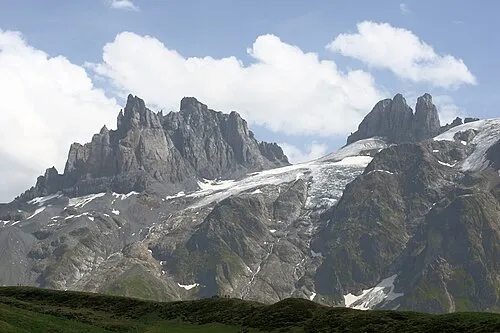
Gross Spannort Mussklprozz · CC BY-SA 3.0

Climate of Sass Stock
This month · November
A wet month
Day -4° · Night -10° · Rain 127 mm
- Hottest month
- August (day 8°)
- Coldest month
- February (night -14°)
- Wettest month
- July (163 mm)
- Driest month
- February (97 mm)
Bars: average monthly low and high temperature. Below: precipitation. Monthly averages for 1970–2000 at about 18 km resolution, adjusted for elevation. Highlighted months are mild and relatively dry. Source: WorldClim 2.1 (CC BY 4.0).
Show values as a table
| Month | Jan | Feb | Mar | Apr | May | Jun | Jul | Aug | Sep | Oct | Nov | Dec |
|---|---|---|---|---|---|---|---|---|---|---|---|---|
| Average high (°C) | -7° | -7° | -6° | -4° | 1° | 5° | 8° | 8° | 5° | 1° | -4° | -6° |
| Average low (°C) | -13° | -14° | -12° | -10° | -5° | -2° | 0° | 1° | -2° | -5° | -10° | -12° |
| Precipitation (mm) | 104 | 97 | 113 | 135 | 140 | 160 | 163 | 157 | 135 | 131 | 127 | 112 |
How to get to Sass Stock
The nearest airport is Zürich Airport (ZRH), 77 km to the north as the crow flies. The nearest large city is Zurich, 67 km to the north.
Airports
- Zürich Airport (ZRH) Zurich 77 kmnorth
- Bern Airport (BRN) Bern 84 kmwest
- Lugano Airport (LUG) Agno 89 kmsouth
Nearby large cities
- Zurich Population: 415.4K 67 kmnorth
- Winterthur Population: 111.8K 83 kmnorth
- Bern Population: 121.6K 88 kmwest
- Basel Population: 177.6K 116 kmnorthwest
- Mulhouse Population: 111.4K 145 kmnorthwest
Straight-line distances; road distances are longer. Airport data: OurAirports.
Day trips from Sass Stock
Within 100 km: 261 historic and cultural sites, 6,938 natural sites, 988 lakes, rivers and coasts.
0–25 km1,256 places
- Neptun-Inseln Island 14 kmN
- Lorelei-Inseln Island 15 kmN
- Oberalpsee Lake 14 kmSE
- Lago di Lucendro Lake 23 kmS
25–60 km2,971 places
- Strandbad Neuhaus Beach 59 kmW
- Strandbad Manor Farm Beach 59 kmW
- Strandbad Iseltwald Beach 46 kmW
- Strandbad Brienz Beach 40 kmW
60–100 km3,960 places
- Kleiner Bremgartenwald Mountain 90 kmW
- Fahr Abbey Attraction 72 kmN
- Strandbad Leissigen Beach 63 kmW
- Arbeiterstrandbad Tennwil Beach 66 kmNW
Straight-line distances.
Nearest towns and villages
-
Erstfeld Municipality, Uri5.4 km N
-
Gurtnellen Village, Gurtnellen5.2 km SE
-
Wassen Municipality, Uri5.6 km SW
-
Silenen Village, Gurtnellen7.9 km E
-
Attinghausen Municipality, Uri7.2 km N
-
Wassen Village, Wassen6.9 km S
Nearby attractions & nature
Everything nearby-
Schrotenstock Mountain, Gurtnellen0.4 km SE
-
Balmenstock Mountain, Gurtnellen0.6 km S
-
Grüenplänggistock Mountain, Gurtnellen0.7 km N
-
Hinterseeli Lake, Gurtnellen0.6 km NE
-
Schneehüenderstöckli Mountain, Gurtnellen1.1 km N
-
Erzstock Mountain, Gurtnellen1.2 km SE
-
Wichelhorn Mountain, Gurtnellen1.3 km NE
-
Brämplisplanggenstock Mountain, Gurtnellen1.3 km E
Sources & licences
Data last updated: