- Elevation
- 2,733 m
- above sea level
- Local time
- UTC+01:00
- Europe/Zurich · UTC+01:00
- Airports
- ZRH Zürich Airport72 km
- LUG Lugano Airport92 km
About Hinter Griessstock
Hinter Griessstock is a mountain. Location: Unterschächen, Uri. Elevation: 2,733 m. The nearest airport is Zürich Airport (72 km). Nearby sights include Griessstock and Mittler Griessstock.
Photos of Hinter Griessstock
-
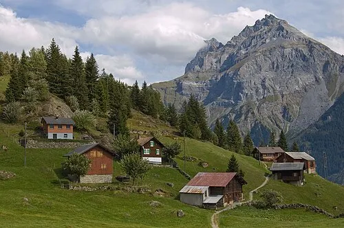
Gross Windgällen Simon Koopmann · CC BY-SA 2.5 -
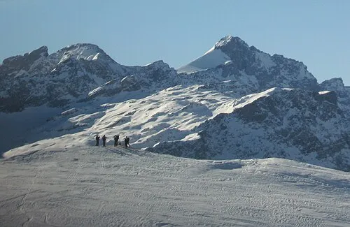
Gross Ruchen Franco Pecchio from Milano, Italy · CC BY 2.0


Climate of Hinter Griessstock
This month · November
A wet month
Day -4° · Night -9° · Rain 135 mm
- Hottest month
- August (day 8°)
- Coldest month
- February (night -13°)
- Wettest month
- July (170 mm)
- Driest month
- February (101 mm)
Bars: average monthly low and high temperature. Below: precipitation. Monthly averages for 1970–2000 at about 18 km resolution, adjusted for elevation. Highlighted months are mild and relatively dry. Source: WorldClim 2.1 (CC BY 4.0).
Show values as a table
| Month | Jan | Feb | Mar | Apr | May | Jun | Jul | Aug | Sep | Oct | Nov | Dec |
|---|---|---|---|---|---|---|---|---|---|---|---|---|
| Average high (°C) | -7° | -7° | -5° | -3° | 1° | 5° | 8° | 8° | 5° | 1° | -4° | -6° |
| Average low (°C) | -13° | -13° | -12° | -9° | -5° | -2° | 1° | 1° | -2° | -5° | -9° | -12° |
| Precipitation (mm) | 112 | 101 | 120 | 143 | 145 | 164 | 170 | 164 | 147 | 139 | 135 | 119 |
How to get to Hinter Griessstock
The nearest airport is Zürich Airport (ZRH), 72 km to the north as the crow flies. The nearest large city is Zurich, 63 km to the north.
Airports
- Zürich Airport (ZRH) Zurich 72 kmnorth
- Lugano Airport (LUG) Agno 92 kmsouth
- Sankt Gallen Altenrhein Airport (ACH) St. Gallen 93 kmnortheast
Nearby large cities
- Zurich Population: 415.4K 63 kmnorth
- Winterthur Population: 111.8K 75 kmnorth
- Bern Population: 121.6K 104 kmwest
- Basel Population: 177.6K 123 kmnorthwest
- Freiburg im Breisgau Population: 237.5K 148 kmnorthwest
Straight-line distances; road distances are longer. Airport data: OurAirports.
Day trips from Hinter Griessstock
Within 100 km: 313 historic and cultural sites, 7,040 natural sites, 1,055 lakes, rivers and coasts.
0–25 km1,015 places
- Neptun-Inseln Island 17 kmNW
- Lorelei-Inseln Island 17 kmNW
- Oberalpsee Lake 22 kmSW
- Lag Crest Ault Lake 12 kmS
25–60 km3,128 places
- Strandbad Brienz Beach 59 kmW
- Lago Nero Lake 47 kmSW
- Ufenau Island 43 kmN
- Insel Lützelau Island 43 kmN
60–100 km4,265 places
- Fahr Abbey Attraction 70 kmNW
- Dominikanerinsel Konstanz Island 97 kmN
- Strandbad Steckborn Beach 93 kmN
- Strandbad Neuhaus Beach 77 kmW
Straight-line distances.
Nearest towns and villages
-
Unterschächen Village, Unterschächen4.4 km NW
-
Aesch Village, Unterschächen3.9 km N
-
Vorder Boden Village, Unterschächen4.2 km W
-
Silenen Municipality, Uri7.3 km SW
-
Heitmannsegg Village, Unterschächen4.9 km N
-
Spiringen Village, Spiringen7.3 km NW
Nearby attractions & nature
Everything nearby-
Griessstock Mountain, Canton of Uri0.3 km NW
-
Mittler Griessstock Mountain, Unterschächen0.4 km NW
-
Vorder Griessstock Mountain, Unterschächen0.9 km N
-
Mittaghorn Mountain, Unterschächen0.9 km N
-
Bocktschingelfirn Natural site, Silenen1.1 km SE
-
Chli Ruchen Mountain, Silenen1.3 km S
-
Huetstöckli Mountain, Silenen1.3 km SE
-
Wäspen Mountain, Unterschächen1.4 km NW
More nature in Switzerland
-
Gross Ruchen Mountain, Unterschächen3.3 km SW
-
Chli Schärhorn Mountain, Unterschächen1.5 km E
-
Chüewäspen Mountain, Unterschächen1.8 km W
-
Ober Firnband Natural site, Unterschächen1.3 km SW
-
Plangger Butzli Mountain, Unterschächen1.9 km NW
-
Gross Schärhorn Mountain, Unterschächen2 km E
Sources & licences
Data last updated: