Dreiländerspitze
Located in Scuol, Region Engiadina Bassa / Val Müstair Coordinates: 46°51′04″ N 10°08′42″ E
- Elevation
- 3,197 m
- above sea level
- Local time
- UTC+01:00
- Europe/Vienna · UTC+01:00
- Airports
- ACH Sankt Gallen Altenrhein Airport83 km
- BZO Bolzano Airport100 km
About Dreiländerspitze
Dreiländerspitze is a mountain. Location: Scuol, Region Engiadina Bassa / Val Müstair. Elevation: 3,197 m.
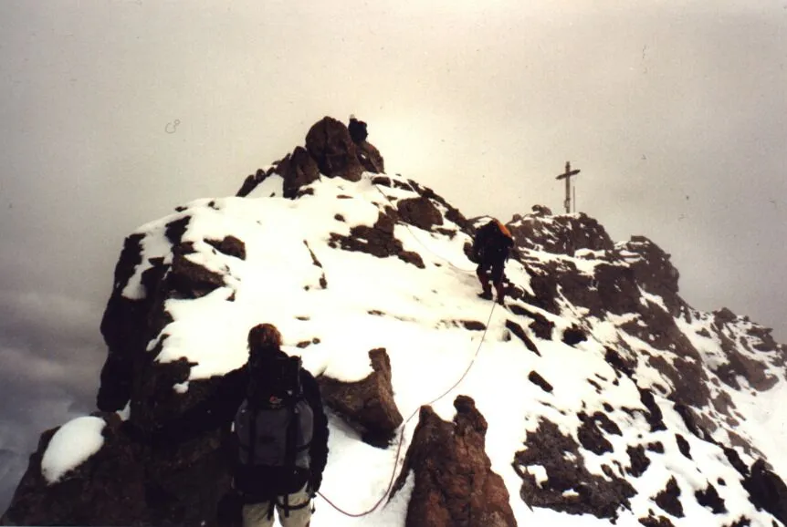
The Dreiländerspitze is with 3,197 m (10,489 ft) one of the higher mountains in the Silvretta range in the eastern Alps and located on the Austria–Switzerland border. The borders of the Swiss canton of Graubünden and the Austrian states of Vorarlberg and Tyrol meet at the peak. Its name (Dreiländerspitze means peak of three countries) refers to a meeting point between the territories of three ancient tribes (Rhaeto-Romance or Romansch, Bavarii and Alamanni) and their languages.
Source: Wikipedia · CC BY-SA 4.0
At a glance
- Topographic prominence
- 306 m
Source: Wikidata
Photos of Dreiländerspitze
-

32 Fuß-Freak · CC BY-SA 4.0 -

Whgler · CC BY-SA 4.0 -

32-Fuß-Freak · CC BY-SA 4.0 -

32-Fuß-Freak · CC BY-SA 4.0 -

Stefan.straub · CC BY 4.0


Climate of Dreiländerspitze
This month · November
A cold month
Day -7° · Night -13° · Rain 96 mm
- Hottest month
- July (day 6°)
- Coldest month
- February (night -18°)
- Wettest month
- July (142 mm)
- Driest month
- February (78 mm)
Bars: average monthly low and high temperature. Below: precipitation. Monthly averages for 1970–2000 at about 18 km resolution, adjusted for elevation. Highlighted months are mild and relatively dry. Source: WorldClim 2.1 (CC BY 4.0).
Show values as a table
| Month | Jan | Feb | Mar | Apr | May | Jun | Jul | Aug | Sep | Oct | Nov | Dec |
|---|---|---|---|---|---|---|---|---|---|---|---|---|
| Average high (°C) | -11° | -10° | -8° | -6° | -1° | 3° | 6° | 6° | 3° | -1° | -7° | -9° |
| Average low (°C) | -18° | -18° | -15° | -13° | -8° | -5° | -3° | -3° | -5° | -8° | -13° | -16° |
| Precipitation (mm) | 89 | 78 | 89 | 90 | 98 | 130 | 142 | 133 | 105 | 88 | 96 | 94 |
How to get to Dreiländerspitze
The nearest airport is Sankt Gallen Altenrhein Airport (ACH), 83 km to the northwest as the crow flies. For international flights: Innsbruck Airport (INN) (102 km). The nearest large city is Innsbruck, 105 km to the northeast.
Airports
- Sankt Gallen Altenrhein Airport (ACH) St. Gallen 83 kmnorthwest
- Bolzano Airport (BZO) Bolzano (BZ) 100 kmsoutheast
- Innsbruck Airport (INN) Innsbruck 102 kmnortheast
Nearby large cities
- Innsbruck Population: 132.5K 105 kmnortheast
- Winterthur Population: 111.8K 130 kmnorthwest
- Zurich Population: 415.4K 134 kmnorthwest
- Ulm Population: 120.5K 172 kmnorth
- Augsburg Population: 301.1K 178 kmnorth
Straight-line distances; road distances are longer. Airport data: OurAirports.
Day trips from Dreiländerspitze
Within 100 km: 214 historic and cultural sites, 6,189 natural sites, 951 lakes, rivers and coasts.
0–25 km759 places
- Lake Davos Lake 23 kmW
- Gotschnaseeli Lake 23 kmW
- Lai Sura Lake 14 kmS
- Furggasee Lake 21 kmSW
25–60 km2,561 places
- Chaviolas Island 57 kmSW
- Lajets Lake 58 kmSW
- Silvaplanersee Lake 52 kmSW
- Lake Sils Lake 57 kmSW
60–100 km4,034 places
- Spadalone Mountain 90 kmSE
- Walensee Lake 78 kmNW
- Wägitalersee Lake 97 kmW
- Lago di Poschiavo Lake 63 kmS
Straight-line distances.
Nearest towns and villages

Nearby attractions & nature
Everything nearby-
Piz Jeramias Mountain, Scuol0.5 km SW
-
Vadret Tuoi Natural site, Scuol0.4 km SE
-
Vorderer Jamspitz Mountain, Grisons0.7 km E
-
Piz Tuoi Mountain, Scuol0.9 km SE
-
Hinter Jamspitz Mountain, Scuol0.9 km E
-
Piz Mon Mountain, Grisons1.1 km W
-
Piz Urezzas Mountain, Scuol1.2 km SE
-
Ochsenkopf Mountain, Tyrol1.3 km N
More nature in Switzerland
-
 Augstenberg Mountain, Scuol4.7 km E
-
Piz Furcletta Mountain, Scuol1.6 km SE
-
Piz da las Cavigliadas Mountain, Scuol2.3 km S
-
Mot Ruderas Mountain, Scuol2.8 km S
-
Piz Chaschlogna Mountain, Scuol3.1 km E
-
Piz Urschai Dadaint Mountain, Scuol3.2 km E
Sources & licences
Data last updated: · 2 independent sources