- Elevation
- 3,098 m
- above sea level
- Local time
- UTC+01:00
- Europe/Zurich · UTC+01:00
- Airports
- ACH Sankt Gallen Altenrhein Airport69 km
- ZRH Zürich Airport81 km
About Piz Segnas
Piz Segnas is a mountain. Location: Flims, Region Imboden. Elevation: 3,098 m.
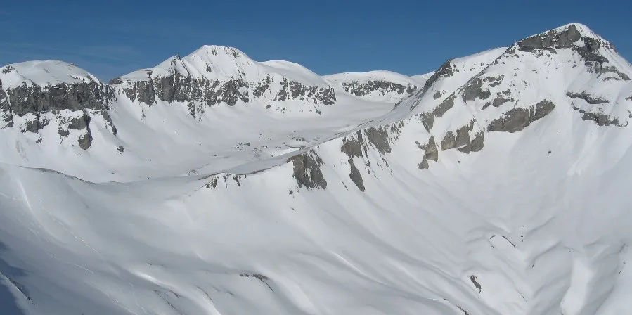
Piz Segnas is a mountain in the Glarus Alps, located on the border between the Swiss cantons of Glarus and Grisons (Graubünden). The Piz Sardona is on the same ridge to the north, from where the Piz Dolf/Trinserhorn lies to the southeast. The Tschingelhörner with the famous Martinsloch (hole of St. Martin) lies to the west, with the Pass dil Segnas between the two mountains. The mountain lies in the municipalities of Flims, in the canton of Grisons, and Glarus Süd, in the canton of Glarus.
Source: Wikipedia · CC BY-SA 4.0
At a glance
- Topographic prominence
- 607 m
Source: Wikidata
Photos of Piz Segnas
-

Whgler · CC BY 4.0 -

Whgler · CC BY 4.0 -

Whgler · CC BY 4.0 -

Whgler · CC BY 4.0 -

Adrian Michael · CC BY-SA 3.0


Climate of Piz Segnas
This month · November
A wet month
Day -6° · Night -12° · Rain 151 mm
- Hottest month
- August (day 6°)
- Coldest month
- February (night -16°)
- Wettest month
- July (206 mm)
- Driest month
- February (115 mm)
Bars: average monthly low and high temperature. Below: precipitation. Monthly averages for 1970–2000 at about 18 km resolution, adjusted for elevation. Highlighted months are mild and relatively dry. Source: WorldClim 2.1 (CC BY 4.0).
Show values as a table
| Month | Jan | Feb | Mar | Apr | May | Jun | Jul | Aug | Sep | Oct | Nov | Dec |
|---|---|---|---|---|---|---|---|---|---|---|---|---|
| Average high (°C) | -9° | -9° | -7° | -5° | 0° | 3° | 6° | 6° | 3° | -1° | -6° | -8° |
| Average low (°C) | -16° | -16° | -14° | -12° | -7° | -4° | -2° | -2° | -4° | -8° | -12° | -15° |
| Precipitation (mm) | 130 | 115 | 131 | 154 | 158 | 190 | 206 | 193 | 170 | 148 | 151 | 139 |
How to get to Piz Segnas
The nearest airport is Sankt Gallen Altenrhein Airport (ACH), 69 km to the north as the crow flies. For international flights: Zürich Airport (ZRH) (81 km). The nearest large city is Zurich, 73 km to the northwest.
Airports
- Sankt Gallen Altenrhein Airport (ACH) St. Gallen 69 kmnorth
- Zürich Airport (ZRH) Zurich 81 kmnorthwest
- Bodensee Airport Friedrichshafen (FDH) Friedrichshafen 87 kmnorth
Nearby large cities
- Zurich Population: 415.4K 73 kmnorthwest
- Winterthur Population: 111.8K 77 kmnorthwest
- Bern Population: 121.6K 137 kmwest
- Basel Population: 177.6K 145 kmnorthwest
- Freiburg im Breisgau Population: 237.5K 160 kmnorthwest
Straight-line distances; road distances are longer. Airport data: OurAirports.
Day trips from Piz Segnas
Within 100 km: 345 historic and cultural sites, 7,279 natural sites, 1,166 lakes, rivers and coasts.
0–25 km677 places
- Walensee Lake 24 kmN
- Klöntalersee Lake 24 kmNW
- Lag Prau Pulté Lake 9 kmS
- Scheubsbach Lake 6 kmNE
25–60 km3,204 places
- Ufenau Island 49 kmNW
- Insel Lützelau Island 49 kmNW
- Schönenwerd Island 52 kmNW
- Insel Schwanau Island 51 kmW
60–100 km4,909 places
- Mainau Island 89 kmN
- Fahr Abbey Attraction 82 kmNW
- Dominikanerinsel Konstanz Island 84 kmN
- Strandbad Steckborn Beach 86 kmN
Straight-line distances.
Nearest towns and villages
Nearby attractions & nature
Everything nearby-
Glatschiu dil Segnas Natural site, Flims0.8 km NE
-
Atlas Mountain, Flims1.1 km S
-
Scheitelgrat Mountain, Glarus Süd1.1 km NW
-
Sardonagletscher Natural site, Pfäfers1.6 km NE
-
Grosses Tschingelhorn Mountain, Flims1.8 km SW
-
Piz Sardona Mountain, Glarus Süd1.9 km NE
-
Tschingelhörner Mountain, Switzerland2 km SW
-
Mörder Mountain, Glarus Süd2 km W
Sources & licences
Data last updated: · 2 independent sources