Odiliapeel
Located in Maashorst, North Brabant Coordinates: 51°38′36″ N 5°42′20″ E
- Population
- 1,390
- 1.4K
- Elevation
- 23 m
- above sea level
- Local time
- UTC+01:00
- Europe/Amsterdam · UTC+01:00
About Odiliapeel
Odiliapeel is a village. Location: Maashorst, North Brabant. Population: 1,390. Elevation: 23 m.
Odiliapeel (Brabantian: De Piejel) is a village in the Netherlands. It is situated in the northeast corner of the province of North Brabant, south of Volkel Air Base. It used to be part of the municipality of Uden, but merged into the municipality of Maashorst in 2022. Odiliapeel was founded in 1921 as a peat excavation settlement. On 5 May 1930, it was officially named Odiliapeel, and is a combination of Odilia of Cologne and the region Peel.
Read more on Wikipedia Text: Wikipedia contributors · CC BY-SA 4.0 · shortened
In comparison
- No. 10 of 12 places in Maashorst by population
- Nearest larger town: Volkel, 4 km W
Nearby attractions & nature
Everything nearby-
Hondsberg Mountain, Land van Cuijk16 km SE
-
Sint Michielsgestel Concentration Camp Historic site, Sint-Michielsgestel Municipality24 km W
-
Vliegenberg Mountain, Land van Cuijk22 km E
-
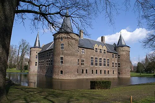 Kasteel Helmond Historic site, Gemeente Helmond19 km S
-
Kiekberg Mountain, Mook en Middelaar Municipality19 km NE
-
Sint Jansberg Mountain, Mook en Middelaar Municipality19 km NE
Sources & licences
Data last updated: · 2 independent sources