Manisa Province
Local name: Manisa ili
Located in Turkey Coordinates: 38°50′00″ N 28°10′00″ E
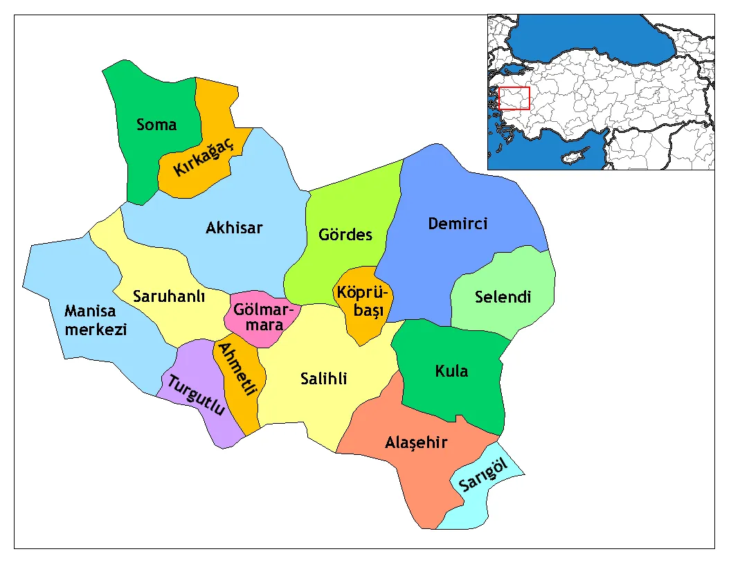
- Population
- 1,468,279
- 1.5M
- Elevation
- 585 m
- above sea level
- Local time
- UTC+03:00
- Europe/Istanbul · UTC+03:00
- Places inside
- 108
- listed under Manisa Province
About Manisa Province
Manisa Province is a region. Location: Turkey. Population: 1,468,279.
Manisa Province (Turkish: Manisa ili) is a province and metropolitan municipality in western Turkey. Its area is 13,339 km2, and its population is 1,468,279 (2022). Its neighboring provinces are İzmir to the west, Aydın to the south, Denizli to the southeast, Uşak to the east, Kütahya to the northeast, and Balıkesir to the north. The city of Manisa is the seat and capital of the province. The traffic code is 45.
Read more on Wikipedia Text: Wikipedia contributors · CC BY-SA 4.0 · shortened
At a glance
- Area
- 13,339 km²
Source: Wikidata
In comparison
- 2 sights and natural places within 10 km Azım Dağı, Kayacık Çayı
- Listed here: River: 48, Municipality: 23, District: 17, Village: 10
Places in Manisa Province
108 places-
Manisa City244K
-
Yunusemre District199.7K
-
Şehzadeler District164.6K
-
Akhisar İlçesi District161.9K
-
Salihli İlçesi District156.3K
-
Turgutlu İlçesi District148.1K
-
Soma İlçesi District105.4K
-
Alaşehir İlçesi District99.5K
-
Saruhanlı District53.8K
-
Kırkağaç İlçesi District46.2K
-
Kula District45.9K
-
Demirci İlçesi District43.6K
-
Sarıgöl İlçesi District36.2K
-
Gördes İlçesi District30.3K
-
Selendi İlçesi District22K
-
Ahmetli İlçesi District16.3K
-
Gölmarmara İlçesi District15.4K
-
Köprübaşı İlçesi District14K
-
Adala Bucağı Municipality
-
Ağıl Deresi River
-
Akhisar Bucağı Municipality
-
Alaşehir Bucağı Municipality
-
Alaşehir Çayı River
-
Arifağalar Village
-
Asar Deresi River
-
Ayıkaya Çayı River
-
Aziz Dere River
-
Bağ Deresi River
-
Ballı Dere River
-
Ballık Deresi River
-
Battalbey Village
-
Beşiktaş Deresi River
-
Borlu Bucağı Municipality
-
Çahyar Çayı River
-
Çanşa Deresi River
-
Çeltik Deresi River
-
Darı Deresi River
-
Darıovası Village
-
Değirmen Dere River
-
Değirmen Deresi River
-
Deliiniş Deresi River
-
Demirköpru Barajı Lake
-
Demrek Deresi River
-
Deniz Çayı River
-
Derbent Çayı River
-
Doğancılar Village
-
Domuz Deresi River
-
Elek Deresi River
-
Eynes Çayı River
-
Gelembe Bucağı Municipality
-
Gerne Village
-
Gökçeören Bucağı Municipality
-
Gölmarmara Bucağı Municipality
-
Gördes Bucağı Municipality
-
Gördes Çayı River
-
Gördes-Uşak Platosu Natural site
-
Gözlübaba Mountain
-
Gürdük Deresi River
-
Güre Village
-
Halitpaşa Bucağı Municipality
Largest cities and towns
Nature and heritage in Manisa Province
-
Yağcı Dağı Mountain, Demirci İlçesi
-
Kepez Dağı Mountain, Gördes İlçesi
-
Çarıkbuz Dağı Mountain, Alaşehir İlçesi
-
Çal Dağı Mountain, Turgutlu İlçesi
-
Çal Dağı Mountain, Turgutlu İlçesi
-
Koca Dağ Mountain, Gördes İlçesi
Sources & licences
Data last updated: · 2 independent sources