Dover
Located in Dover District, Kent Coordinates: 51°07′35″ N 1°18′04″ E
- Elevation
- 50 m
- above sea level
- Local time
- UTC+00:00
- Europe/London · UTC+00:00
- Places inside
- 16
- listed under Dover
About Dover
Dover is a village. Location: Dover District, Kent. Elevation: 50 m.
In comparison
- Nearest larger town: Dover, 1 km E
- 29 sights and natural places within 10 km Dover Castle, Roman Lighthouse
- Listed here: Neighbourhood: 7, Landmark: 3, Village: 3, Historic site: 2
Places in Dover
16 places-
Dover Town41.7K
-
Aycliff Neighbourhood
-
Buckland Valley Neighbourhood
-
Clarendon Neighbourhood
-
Crabble Athletic Ground Landmark
-
Dover Admiralty Pier Lighthouse Landmark
-
Dover Castle Historic site
-
Elms Vale Neighbourhood
-
Farthingloe Village
-
Maxton Village
-
Roman Lighthouse Historic site
-
St Radigund's Neighbourhood
-
Tower Hamlets Neighbourhood
-
Victoria Park Mews Village
-
Western Heights Neighbourhood
Nearby attractions & nature
Everything nearby-
Dover Breakwater West End Lighthouse Landmark, Dover District2.5 km SE
-
Swingate Transmitting Station, Tower 2 Landmark, St. Margaret's At Cliffe2.8 km NE
-
Swingate Transmitting Station, Tower 1 Landmark, St. Margaret's At Cliffe2.8 km NE
-
Dover Breakwater Knuckle Lighthouse Landmark, Kent3 km E
-
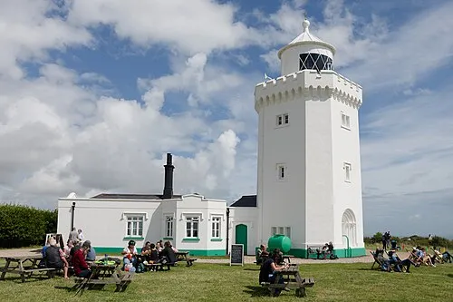 South Foreland Lighthouse Landmark, St. Margaret's At Cliffe5.2 km E
-
Saint Margarets Bay Natural site, England3.5 km NE
Sources & licences
Data last updated: