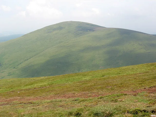
- Elevation
- 714 m
- above sea level
- Local time
- UTC+00:00
- Europe/London · UTC+00:00
- Airports
- NCL Newcastle International Airport55 km
- EDI Edinburgh Airport97 km
About Hedgehope Hill
Hedgehope Hill is a mountain. Location: Ingram, Northumberland. Elevation: 714 m.
Hedgehope Hill is a mountain in the Cheviot Hills of north Northumberland in northeast England, and categorised as a Hewitt. It is the second-highest mountain in the area after The Cheviot itself. At a height of 714 metres (2,343 ft) and a distance of about 3 miles (4.8 km) from the Scottish border, it is best climbed from Langleeford in the Harthope Valley, over which it looms. The Harthope valley is accessible by a minor road from near Wooler to the northeast.
Source: Wikipedia · CC BY-SA 4.0
Photos of Hedgehope Hill
-

Colin Park · CC BY-SA 2.0 -

Colin Park · CC BY-SA 2.0 -

shikari · CC BY-SA 2.0 -

shikari · CC BY-SA 2.0 -

Michael Graham · CC BY-SA 2.0


Climate of Hedgehope Hill
This month · November
A wet month
Day 5° · Night -1° · Rain 138 mm
- Hottest month
- July (day 15°)
- Coldest month
- January (night -4°)
- Wettest month
- January (147 mm)
- Driest month
- June (81 mm)
Bars: average monthly low and high temperature. Below: precipitation. Monthly averages for 1970–2000 at about 18 km resolution, adjusted for elevation. Highlighted months are mild and relatively dry. Source: WorldClim 2.1 (CC BY 4.0).
Show values as a table
| Month | Jan | Feb | Mar | Apr | May | Jun | Jul | Aug | Sep | Oct | Nov | Dec |
|---|---|---|---|---|---|---|---|---|---|---|---|---|
| Average high (°C) | 2° | 2° | 4° | 7° | 10° | 13° | 15° | 15° | 12° | 9° | 5° | 3° |
| Average low (°C) | -4° | -3° | -2° | -1° | 1° | 4° | 6° | 6° | 4° | 2° | -1° | -3° |
| Precipitation (mm) | 147 | 103 | 113 | 82 | 85 | 81 | 89 | 109 | 113 | 139 | 138 | 135 |
How to get to Hedgehope Hill
The nearest airport is Newcastle International Airport (NCL), 55 km to the southeast as the crow flies. The nearest large city is Newcastle upon Tyne, 63 km to the southeast.
Airports
- Newcastle International Airport (NCL) Newcastle upon Tyne, Tyne and Wear 55 kmsoutheast
- Edinburgh Airport (EDI) Ingliston, Edinburgh 97 kmnorthwest
- Teesside International Airport (MME) Darlington, Durham 115 kmsouth
Nearby large cities
- Newcastle upon Tyne Population: 300.1K 63 kmsoutheast
- Sunderland Population: 170.1K 78 kmsoutheast
- Edinburgh Population: 515K 88 kmnorthwest
- Middlesbrough Population: 142.7K 114 kmsoutheast
- Dundee Population: 148.2K 124 kmnorthwest
Straight-line distances; road distances are longer. Airport data: OurAirports.
Day trips from Hedgehope Hill
Within 100 km: 580 historic and cultural sites, 1,541 natural sites, 407 lakes, rivers and coasts.
0–25 km342 places
- Great Haugh Island 24 kmN
- Yetholm Loch Lake 17 kmNW
- Hoselaw Loch Lake 18 kmNW
- Yeavering Bell Mountain 10 kmN
25–60 km740 places
- Cocklawburn Beach Beach 30 kmN
- Cheswick Sands Beach 29 kmN
- Longhoughton Beach Beach 32 kmE
- South Wamses Island 35 kmNE
60–100 km1,446 places
- Burntisland Beach Beach 97 kmNW
- Cramond beach Beach 95 kmNW
- Portobello Beach Beach 84 kmNW
- Gullane Beach Beach 79 kmNW
Straight-line distances.
Nearest towns and villages
Nearby attractions & nature
Everything nearby-
Great Standrop Mountain, Ingram1.7 km S
-
Comb Fell Mountain, Ingram2.2 km SW
-
Dunmoor Hill Mountain, Ingram2.8 km SE
-
Langlee Crags Mountain, Ilderton3.2 km NE
-
The Cheviot Mountain, Earle3.6 km W
-
Broadhope Hill Mountain, Earle3.8 km N
-
Ritto Hill Mountain, Ingram3.8 km S
-
Cairn Hill Mountain, Earle4 km W
Sources & licences
Data last updated: · 2 independent sources