Cruach na Seilcheig
Located in Argyll and Bute, Scotland Coordinates: 56°07′21″ N 5°44′14″ W
- Elevation
- 304 m
- above sea level
- Local time
- UTC+00:00
- Europe/London · UTC+00:00
- Airports
- ILY Islay Airport59 km
- CAL Campbeltown Airport76 km
About Cruach na Seilcheig
Cruach na Seilcheig is a mountain. Location: Argyll and Bute, Scotland. Elevation: 304 m. The nearest airport is Islay Airport (59 km). Nearby sights include Beinn nan Capull and Sgorr Mhor.
Photos of Cruach na Seilcheig
-
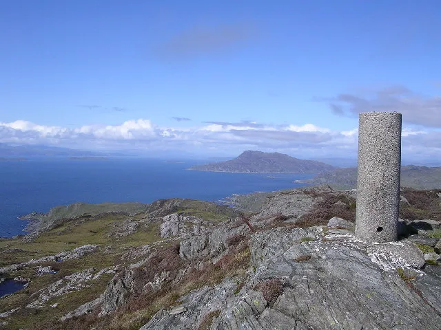
Ben Garrisdale Chris Upson · CC BY-SA 2.0

Climate of Cruach na Seilcheig
This month · November
A wet month
Day 8° · Night 4° · Rain 200 mm
- Hottest month
- July (day 16°)
- Coldest month
- February (night 2°)
- Wettest month
- January (218 mm)
- Driest month
- May (79 mm)
Bars: average monthly low and high temperature. Below: precipitation. Monthly averages for 1970–2000 at about 18 km resolution, adjusted for elevation. Highlighted months are mild and relatively dry. Source: WorldClim 2.1 (CC BY 4.0).
Show values as a table
| Month | Jan | Feb | Mar | Apr | May | Jun | Jul | Aug | Sep | Oct | Nov | Dec |
|---|---|---|---|---|---|---|---|---|---|---|---|---|
| Average high (°C) | 6° | 6° | 7° | 10° | 13° | 15° | 16° | 16° | 14° | 11° | 8° | 6° |
| Average low (°C) | 2° | 2° | 3° | 4° | 6° | 9° | 10° | 10° | 9° | 6° | 4° | 2° |
| Precipitation (mm) | 218 | 132 | 165 | 98 | 79 | 87 | 111 | 132 | 176 | 193 | 200 | 198 |
How to get to Cruach na Seilcheig
The nearest airport is Islay Airport (ILY), 59 km to the southwest as the crow flies. The nearest large city is Glasgow, 97 km to the east.
Airports
- Islay Airport (ILY) Isle of Islay, Argyll and Bute 59 kmsouthwest
- Campbeltown Airport (CAL) Campbeltown 76 kmsouth
- Tiree Airport (TRE) Balemartine, Argyll and Bute 82 kmnorthwest
Nearby large cities
- Glasgow Population: 626.4K 97 kmeast
- Edinburgh Population: 515K 159 kmeast
- Belfast Population: 348K 170 kmsouth
- Dundee Population: 148.2K 175 kmeast
- Aberdeen Population: 198.6K 251 kmnortheast
Straight-line distances; road distances are longer. Airport data: OurAirports.
Day trips from Cruach na Seilcheig
Within 100 km: 84 historic and cultural sites, 2,759 natural sites, 1,219 lakes, rivers and coasts.
0–25 km500 places
- Scarba Island 7 kmN
- Cala Island 15 kmSE
- Torsa Island Island 17 kmNE
- Shuna Island 14 kmNE
25–60 km1,557 places
- Colonsay Island 30 kmW
- Kiloran Beach Beach 28 kmW
- Oronsay Island 35 kmW
- Eriska Island 50 kmNE
60–100 km2,005 places
- Isle of Arran Island 66 kmSE
- Great Cumbrae Island Island 65 kmSE
- Eigg Island 91 kmN
- Troon Beach Beach 94 kmSE
Straight-line distances.
Nearest towns and villages
-
 Kinuachdrachd Village, Argyll and Bute2.6 km E
-
Aird Village, Argyll and Bute9 km E
-
 Ardlussa Village, Argyll and Bute11 km S
-
 Inverlussa Village, Argyll and Bute12 km S
-
Blackmill Bay Village, Argyll and Bute11 km NE
-
Crinan Village, Argyll and Bute12 km E
Nearby attractions & nature
Everything nearby-
Beinn nan Capull Mountain, Argyll and Bute0.8 km N
-
Sgorr Mhor Mountain, Argyll and Bute0.8 km SW
-
Cruach Glen Trosdale Mountain, Argyll and Bute1.4 km NE
-
Beinn Bhiorgaig Mountain, Argyll and Bute1.6 km E
-
Beul Leathad Mountain, Argyll and Bute2 km SE
-
Maol nan Damh Mountain, Argyll and Bute2.2 km NE
-
Glas Bheinn Mountain, Argyll and Bute2.5 km S
-
An Cruachan Mountain, Argyll and Bute2.9 km NE
More nature in United Kingdom
-
Ben Garrisdale Mountain, Argyll and Bute6 km SW
-
Clachaig Mhor Mountain, Argyll and Bute3 km SW
-
Con Tom Mountain, Argyll and Bute3 km E
-
Aird Rachdaig Mountain, Argyll and Bute4.2 km W
-
Cruach Coire Buidhe Mountain, Argyll and Bute5 km N
-
Carn nan Gillean Mountain, Argyll and Bute5.6 km SW
Sources & licences
Data last updated: