- Local time
- UTC+00:00
- Europe/London · UTC+00:00
- Airports
- ILY Islay Airport69 km
- TRE Tiree Airport74 km
About Sgeir a' Phuirt
Sgeir a' Phuirt is an island. Location: Argyll and Bute, Scotland. The nearest airport is Islay Airport (69 km). Nearby sights include Cnoc Bealach an Tarabairt and Cnoc Port nan Aidhean.
Photos of Sgeir a' Phuirt
-
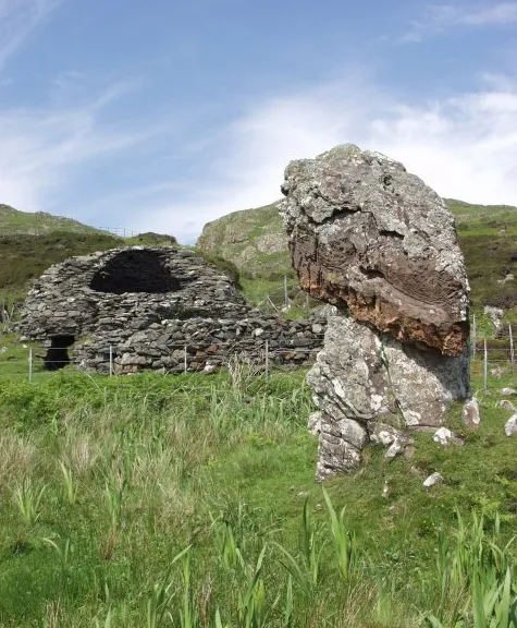
Eileach an Naoimh Christopher Bruce · CC BY-SA 2.0

Climate of Sgeir a' Phuirt
This month · November
A wet month
Day 10° · Night 6° · Rain 211 mm
- Hottest month
- August (day 17°)
- Coldest month
- February (night 4°)
- Wettest month
- January (229 mm)
- Driest month
- May (82 mm)
Bars: average monthly low and high temperature. Below: precipitation. Monthly averages for 1970–2000 at about 18 km resolution, adjusted for elevation. Highlighted months are mild and relatively dry. Source: WorldClim 2.1 (CC BY 4.0).
Show values as a table
| Month | Jan | Feb | Mar | Apr | May | Jun | Jul | Aug | Sep | Oct | Nov | Dec |
|---|---|---|---|---|---|---|---|---|---|---|---|---|
| Average high (°C) | 8° | 7° | 8° | 10° | 13° | 15° | 17° | 17° | 15° | 12° | 10° | 8° |
| Average low (°C) | 4° | 4° | 4° | 5° | 8° | 10° | 12° | 12° | 10° | 8° | 6° | 4° |
| Precipitation (mm) | 229 | 139 | 171 | 102 | 82 | 91 | 113 | 137 | 186 | 203 | 211 | 209 |
How to get to Sgeir a' Phuirt
The nearest airport is Islay Airport (ILY), 69 km to the southwest as the crow flies. The nearest large city is Glasgow, 103 km to the southeast.
Airports
- Islay Airport (ILY) Isle of Islay, Argyll and Bute 69 kmsouthwest
- Tiree Airport (TRE) Balemartine, Argyll and Bute 74 kmnorthwest
- Campbeltown Airport (CAL) Campbeltown 90 kmsouth
Nearby large cities
- Glasgow Population: 626.4K 103 kmsoutheast
- Edinburgh Population: 515K 163 kmeast
- Dundee Population: 148.2K 174 kmeast
- Belfast Population: 348K 183 kmsouth
- Aberdeen Population: 198.6K 246 kmnortheast
Straight-line distances; road distances are longer. Airport data: OurAirports.
Day trips from Sgeir a' Phuirt
Within 100 km: 66 historic and cultural sites, 2,985 natural sites, 1,247 lakes, rivers and coasts.
0–25 km459 places
- Scarba Island 7 kmSE
- Torsa Island Island 9 kmE
- Shuna Island 10 kmE
- Seil Island 10 kmNE
25–60 km1,651 places
- Colonsay Island 34 kmSW
- Kiloran Beach Beach 30 kmSW
- Oronsay Island 48 kmN
- Oronsay Island 40 kmSW
60–100 km2,188 places
- Isle of Arran Island 78 kmSE
- Great Cumbrae Island Island 74 kmSE
- Eigg Island 78 kmN
- Hunterston Sands Beach 79 kmSE
Straight-line distances.
Nearest towns and villages
-
Cullipool Village, Argyll and Bute7 km E
-
Blackmill Bay Village, Argyll and Bute7.1 km SE
-
Bardrishaig Village, Argyll and Bute7.1 km E
-
South Cuan Village, Argyll and Bute8.1 km E
-
Toberonochy Village, Argyll and Bute8.4 km E
-
Easdale Village, Argyll and Bute8.7 km NE
Nearby attractions & nature
Everything nearby-
Cnoc Bealach an Tarabairt Mountain, Argyll and Bute0.8 km NW
-
Cnoc Port nan Aidhean Mountain, Argyll and Bute0.8 km W
-
Garbh Eileach Island, Argyll and Bute0.4 km N
-
Sgeir Poll an Dobhrain Island, Argyll and Bute0.4 km SW
-
Garvellachs Island, Argyll and Bute1.1 km SW
-
Dùn Chonnuill Island, Argyll and Bute1.4 km NE
-
A’ Chùli Island, Argyll and Bute1.7 km SW
-
Sgeir nam Marag Island, Argyll and Bute1.9 km SW
More lakes, rivers and coasts in United Kingdom
-
Eileach an Naoimh Island, Argyll and Bute3.5 km SW
-
Guirasdeal Island, Argyll and Bute4.5 km SE
-
Eilean Dubh Beag Island, Argyll and Bute2.6 km E
-
Eilean Dubh Mòr Island, Argyll and Bute2.8 km SE
-
Sgeir Leth a' Chuain Island, Argyll and Bute2.3 km SW
-
Eilean Iosal Island, Argyll and Bute4.2 km SE
Sources & licences
Data last updated: