- Elevation
- 705 m
- above sea level
- Local time
- UTC+00:00
- Europe/London · UTC+00:00
- Airports
- WIC Wick John O'Groats Airport72 km
- INV Inverness Airport76 km
About Ben Armine
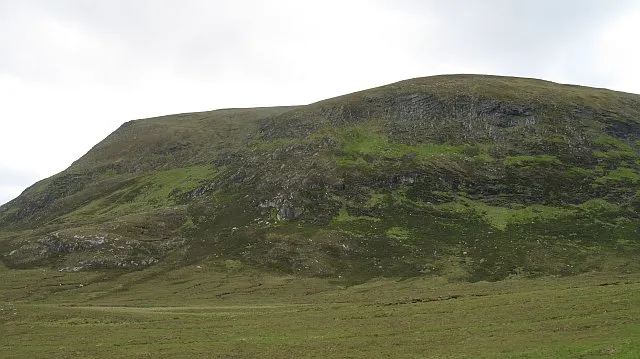
Ben Armine is a mountain. Location: Highland, Scotland. Elevation: 705 m.
Ben Armine (705 m) is a remote hill in Sutherland in the far north of Scotland. It lies in inland, north of the village of Lairg. The best known summit of a range of hills lying southeast of Ben Klibreck, its southern neighbour Creag Mhor is slightly higher.
Source: Wikipedia · CC BY-SA 4.0
Climate of Ben Armine
This month · November
A wet month
Day 4° · Night -1° · Rain 161 mm
- Hottest month
- July (day 13°)
- Coldest month
- February (night -3°)
- Wettest month
- November (161 mm)
- Driest month
- May (78 mm)
Bars: average monthly low and high temperature. Below: precipitation. Monthly averages for 1970–2000 at about 18 km resolution, adjusted for elevation. Highlighted months are mild and relatively dry. Source: WorldClim 2.1 (CC BY 4.0).
Show values as a table
| Month | Jan | Feb | Mar | Apr | May | Jun | Jul | Aug | Sep | Oct | Nov | Dec |
|---|---|---|---|---|---|---|---|---|---|---|---|---|
| Average high (°C) | 2° | 2° | 4° | 6° | 9° | 11° | 13° | 13° | 11° | 8° | 4° | 2° |
| Average low (°C) | -3° | -3° | -2° | -1° | 2° | 4° | 6° | 6° | 4° | 2° | -1° | -3° |
| Precipitation (mm) | 148 | 105 | 131 | 84 | 78 | 88 | 94 | 108 | 136 | 151 | 161 | 147 |
How to get to Ben Armine
The nearest airport is Wick John O'Groats Airport (WIC), 72 km to the northeast as the crow flies. The nearest large city is Aberdeen, 174 km to the southeast.
Airports
- Wick John O'Groats Airport (WIC) Wick 72 kmnortheast
- Inverness Airport (INV) Inverness, Highland 76 kmsouth
- Kirkwall Airport (KOI) Kirkwall, Orkney Islands 113 kmnortheast
Nearby large cities
- Aberdeen Population: 198.6K 174 kmsoutheast
- Dundee Population: 148.2K 208 kmsouth
- Edinburgh Population: 515K 260 kmsouth
- Glasgow Population: 626.4K 262 kmsouth
- Newcastle upon Tyne Population: 300.1K 395 kmsoutheast
Straight-line distances; road distances are longer. Airport data: OurAirports.
Day trips from Ben Armine
Within 100 km: 54 historic and cultural sites, 2,215 natural sites, 639 lakes, rivers and coasts.
0–25 km265 places
- Eilean a' Chairn Island 24 kmSW
- Eilean na Craoibhe Island 24 kmSW
- Eilean nam Meann Island 9 kmNE
- Eilean a' Bhreac-achaidh Island 9 kmN
25–60 km1,224 places
- Eilean Dubh Island 56 kmW
- Whale Islet Island 59 kmNW
- Eilean nan Ron Island 38 kmN
- Rabbit Islands Island 37 kmN
60–100 km1,419 places
- Hoy Island 89 kmNE
- Flotta Island 94 kmNE
- Findlays Seat Mountain 94 kmSE
- Hesta Head Natural site 99 kmNE
Straight-line distances.
Nearest towns and villages
Nearby attractions & nature
Everything nearby-
Meall nan Aighean Mountain, Highland2.1 km NW
-
Creag na h-Iolaire Mountain, Highland2.6 km NW
-
Creag Mhor Mountain, Highland3.3 km S
-
Meall Ard Mountain, Highland3.5 km NW
-
Maol Coire a' Mhile Mountain, Highland4.4 km S
-
Carn nan Ceannaichean Mountain, Highland4.5 km SE
-
Meall Meadhon Mountain, Highland4.5 km W
-
Cnoc Preas an Tairbh Mountain, Highland4.6 km SE
Sources & licences
Data last updated: · 2 independent sources