- Elevation
- 114 m
- above sea level
- Local time
- UTC+00:00
- Europe/London · UTC+00:00
- Airports
- SYY Stornoway Airport66 km
- INV Inverness Airport98 km
About Cnoc Bad a' Baine
Cnoc Bad a' Baine is a mountain. Location: Highland, Scotland. Elevation: 114 m. The nearest airport is Stornoway Airport (66 km). Nearby sights include Cnoc Sloc a' Bhuilg and Cnoc Bad na Conaire.
Photos of Cnoc Bad a' Baine
-
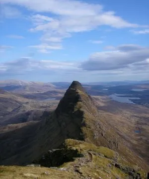
Suilven Original uploader was Grinner at en.wikipedia · CC BY-SA 3.0

Climate of Cnoc Bad a' Baine
This month · November
A wet month
Day 9° · Night 4° · Rain 192 mm
- Hottest month
- July (day 16°)
- Coldest month
- February (night 1°)
- Wettest month
- November (192 mm)
- Driest month
- May (73 mm)
Bars: average monthly low and high temperature. Below: precipitation. Monthly averages for 1970–2000 at about 18 km resolution, adjusted for elevation. Highlighted months are mild and relatively dry. Source: WorldClim 2.1 (CC BY 4.0).
Show values as a table
| Month | Jan | Feb | Mar | Apr | May | Jun | Jul | Aug | Sep | Oct | Nov | Dec |
|---|---|---|---|---|---|---|---|---|---|---|---|---|
| Average high (°C) | 6° | 6° | 8° | 10° | 13° | 14° | 16° | 16° | 14° | 12° | 9° | 6° |
| Average low (°C) | 1° | 1° | 2° | 4° | 6° | 8° | 10° | 10° | 8° | 6° | 4° | 1° |
| Precipitation (mm) | 169 | 117 | 141 | 86 | 73 | 89 | 99 | 115 | 160 | 180 | 192 | 174 |
How to get to Cnoc Bad a' Baine
The nearest airport is Stornoway Airport (SYY), 66 km to the west as the crow flies. The nearest large city is Aberdeen, 218 km to the southeast.
Airports
- Stornoway Airport (SYY) Stornoway, Western Isles 66 kmwest
- Inverness Airport (INV) Inverness, Highland 98 kmsoutheast
- Wick John O'Groats Airport (WIC) Wick 129 kmeast
Nearby large cities
- Aberdeen Population: 198.6K 218 kmsoutheast
- Dundee Population: 148.2K 232 kmsoutheast
- Glasgow Population: 626.4K 263 kmsouth
- Edinburgh Population: 515K 276 kmsoutheast
Straight-line distances; road distances are longer. Airport data: OurAirports.
Day trips from Cnoc Bad a' Baine
Within 100 km: 31 historic and cultural sites, 2,729 natural sites, 892 lakes, rivers and coasts.
0–25 km523 places
- Eilean a' Char Island 21 kmSW
- Eilean Dubh Island 16 kmN
- Tanera More Island 21 kmSW
- Summer Isles Island 23 kmSW
25–60 km1,107 places
- Whale Islet Island 30 kmN
- Eilean Sùbhainn Island 55 kmS
- Eilean Ruairidh Mòr Island 55 kmS
- Priest Island Island 29 kmSW
60–100 km2,022 places
- Isle of Harris Natural site 98 kmW
- Dalmore Beach Beach 92 kmW
- Dailbeag Beach Beach 91 kmW
- Scalpay Island 92 kmW
Straight-line distances.
Nearby attractions & nature
Everything nearby-
Cnoc Sloc a' Bhuilg Mountain, Highland0.9 km SW
-
Cnoc Bad na Conaire Mountain, Highland0.9 km N
-
Cnoc a' Chlamhain Mountain, Highland0.9 km W
-
Cnoc an Tolla Bhaid Mountain, Highland1 km S
-
Cnoc an Aite Mhoir Mountain, Highland1.5 km W
-
Torr a' Gheoidh Mountain, Highland1.6 km S
-
Torr Garbh Mountain, Highland1.7 km SW
-
Cnoc nan Caorach Beaga Mountain, Highland1.7 km N
Sources & licences
Data last updated: