- Elevation
- 92 m
- above sea level
- Local time
- UTC+00:00
- Europe/London · UTC+00:00
- Airports
- SYY Stornoway Airport80 km
- INV Inverness Airport112 km
About Creag an Fhraoich
Creag an Fhraoich is a mountain. Location: Highland, Scotland. Elevation: 92 m. The nearest airport is Stornoway Airport (80 km). Nearby sights include Cnoc an Loin Bhain and Leathad an Seamraig.
Photos of Creag an Fhraoich
-
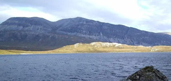
Arkle Donald Bain · CC BY-SA 2.0 -
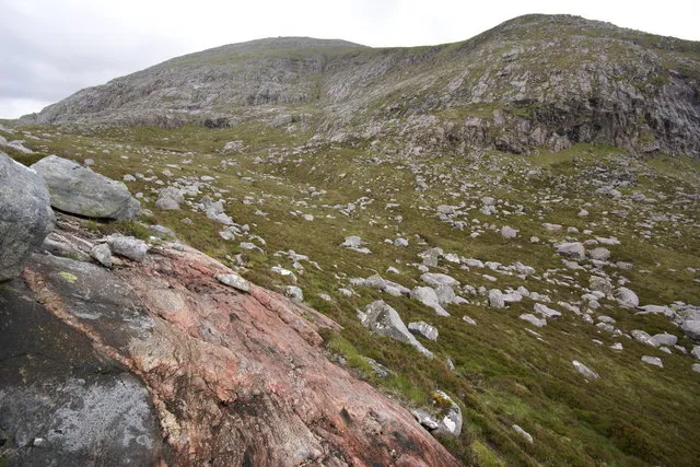
Ceann Garbh Peter Standing · CC BY-SA 2.0


Climate of Creag an Fhraoich
This month · November
A wet month
Day 8° · Night 3° · Rain 168 mm
- Hottest month
- August (day 16°)
- Coldest month
- February (night 1°)
- Wettest month
- November (168 mm)
- Driest month
- May (67 mm)
Bars: average monthly low and high temperature. Below: precipitation. Monthly averages for 1970–2000 at about 18 km resolution, adjusted for elevation. Highlighted months are mild and relatively dry. Source: WorldClim 2.1 (CC BY 4.0).
Show values as a table
| Month | Jan | Feb | Mar | Apr | May | Jun | Jul | Aug | Sep | Oct | Nov | Dec |
|---|---|---|---|---|---|---|---|---|---|---|---|---|
| Average high (°C) | 6° | 6° | 8° | 10° | 13° | 14° | 16° | 16° | 14° | 12° | 8° | 6° |
| Average low (°C) | 1° | 1° | 2° | 4° | 6° | 8° | 10° | 10° | 8° | 6° | 3° | 1° |
| Precipitation (mm) | 142 | 97 | 121 | 77 | 67 | 82 | 92 | 109 | 145 | 159 | 168 | 148 |
How to get to Creag an Fhraoich
The nearest airport is Stornoway Airport (SYY), 80 km to the west as the crow flies. The nearest large city is Aberdeen, 223 km to the southeast.
Airports
- Stornoway Airport (SYY) Stornoway, Western Isles 80 kmwest
- Inverness Airport (INV) Inverness, Highland 112 kmsoutheast
- Wick John O'Groats Airport (WIC) Wick 112 kmeast
Nearby large cities
- Aberdeen Population: 198.6K 223 kmsoutheast
- Dundee Population: 148.2K 248 kmsoutheast
- Glasgow Population: 626.4K 287 kmsouth
- Edinburgh Population: 515K 295 kmsoutheast
Straight-line distances; road distances are longer. Airport data: OurAirports.
Day trips from Creag an Fhraoich
Within 100 km: 26 historic and cultural sites, 1,990 natural sites, 640 lakes, rivers and coasts.
0–25 km474 places
- Eilean Dubh Island 13 kmSW
- Whale Islet Island 8 kmNW
- Oldany Island Island 22 kmSW
- Meall Mòr Island 17 kmSW
25–60 km740 places
- Eilean a' Char Island 50 kmSW
- Tanera More Island 50 kmSW
- Summer Isles Island 51 kmSW
- Soyea Island Island 34 kmSW
60–100 km1,442 places
- Clett Island 89 kmE
- Tannaraidh Island 88 kmW
- Tabhaigh Mor Island 86 kmW
- Crois Eilean Island 89 kmW
Straight-line distances.
Nearest towns and villages
Nearby attractions & nature
Everything nearby-
Cnoc an Loin Bhain Mountain, Highland0.5 km NE
-
Leathad an Seamraig Mountain, Highland0.7 km SW
-
An Cadha Mountain, Highland0.7 km NW
-
Rubha nan Uan Mountain, Highland0.9 km E
-
Cnoc Thull Mountain, Highland1.1 km SE
-
Ceathramh Garbh Mountain, Highland1.5 km N
-
Cnoc Portlevorchy Mountain, Highland1.6 km NW
-
Cnoc Leathan Mountain, Highland1.7 km E
Sources & licences
Data last updated: