- Elevation
- 124 m
- above sea level
- Local time
- UTC+00:00
- Europe/London · UTC+00:00
- Airports
- SYY Stornoway Airport79 km
- INV Inverness Airport82 km
About Eilean an Taighe
Eilean an Taighe is an island. Location: Highland, Scotland. The nearest airport is Stornoway Airport (79 km). Nearby sights include Eilean na Gartaig and Eilean na Gaoithe.
Photos of Eilean an Taighe
-
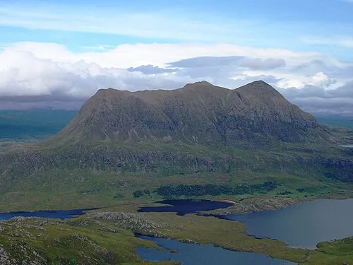
Cul Mor Foxie001 · Public domain -
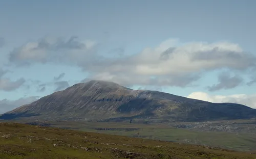
Canisp Paul Hermans · CC BY-SA 3.0


Climate of Eilean an Taighe
This month · November
A wet month
Day 9° · Night 3° · Rain 231 mm
- Hottest month
- July (day 17°)
- Coldest month
- December (night 1°)
- Wettest month
- November (231 mm)
- Driest month
- May (96 mm)
Bars: average monthly low and high temperature. Below: precipitation. Monthly averages for 1970–2000 at about 18 km resolution, adjusted for elevation. Highlighted months are mild and relatively dry. Source: WorldClim 2.1 (CC BY 4.0).
Show values as a table
| Month | Jan | Feb | Mar | Apr | May | Jun | Jul | Aug | Sep | Oct | Nov | Dec |
|---|---|---|---|---|---|---|---|---|---|---|---|---|
| Average high (°C) | 6° | 7° | 8° | 11° | 13° | 15° | 17° | 17° | 15° | 12° | 9° | 6° |
| Average low (°C) | 1° | 1° | 2° | 3° | 5° | 8° | 10° | 10° | 8° | 6° | 3° | 1° |
| Precipitation (mm) | 214 | 149 | 184 | 109 | 96 | 109 | 120 | 140 | 192 | 218 | 231 | 214 |
How to get to Eilean an Taighe
The nearest airport is Stornoway Airport (SYY), 79 km to the west as the crow flies. The nearest large city is Aberdeen, 203 km to the southeast.
Airports
- Stornoway Airport (SYY) Stornoway, Western Isles 79 kmwest
- Inverness Airport (INV) Inverness, Highland 82 kmsoutheast
- Wick John O'Groats Airport (WIC) Wick 121 kmeast
Nearby large cities
- Aberdeen Population: 198.6K 203 kmsoutheast
- Dundee Population: 148.2K 216 kmsoutheast
- Glasgow Population: 626.4K 249 kmsouth
- Edinburgh Population: 515K 260 kmsoutheast
- Belfast Population: 348K 390 kmsouth
Straight-line distances; road distances are longer. Airport data: OurAirports.
Day trips from Eilean an Taighe
Within 100 km: 37 historic and cultural sites, 2,901 natural sites, 832 lakes, rivers and coasts.
0–25 km503 places
- Tanera More Island 24 kmW
- Soyea Island Island 20 kmNW
- Isle Martin Island 18 kmSW
- Horse Island Island 22 kmSW
25–60 km1,430 places
- Eilean a' Char Island 26 kmW
- Eilean Dubh Island 28 kmN
- Whale Islet Island 41 kmN
- Summer Isles Island 26 kmW
60–100 km1,837 places
- Island of Raasay Island 98 kmSW
- Tannaraidh Island 83 kmW
- Tabhaigh Mor Island 80 kmW
- Crois Eilean Island 83 kmW
Straight-line distances.
Nearest towns and villages
-
Elphin Village, Highland0.8 km SW
-
Ledmore Village, Highland2.7 km E
-
Ledbeg Village, Highland2.8 km NE
-
Knockan Village, Highland3.7 km S
-
Stronchrubie Village, Highland7.2 km N
-
 Inchnadamph Village, Highland9.9 km N
Nearby attractions & nature
Everything nearby-
Eilean na Gartaig Island, Highland0.3 km SW
-
Eilean na Gaoithe Island, Highland0.6 km N
-
Cnoc Breac Mountain, Highland1.1 km S
-
Cnoc an Ruadhlaich Mountain, Highland1.2 km W
-
Cnoc an Leathaid Bhig Mountain, Highland1.9 km N
-
Cam Loch Lake, Highland1.6 km NW
-
Cnoc Bad na h-Achlaise Mountain, Highland2.6 km SE
-
Stob Phollain Riabhaich Mountain, Highland2.8 km SW
Sources & licences
Data last updated: