- Elevation
- 661 m
- above sea level
- Local time
- UTC+00:00
- Europe/London · UTC+00:00
- Airports
- GLA Glasgow Airport59 km
- EDI Edinburgh Airport66 km
About Beinn Fuath
Beinn Fuath is a mountain. Location: Perth and Kinross, Scotland. Elevation: 661 m. The nearest airport is Glasgow Airport (59 km). Nearby sights include Am Bioran and Leacan Dubha.
Photos of Beinn Fuath
-
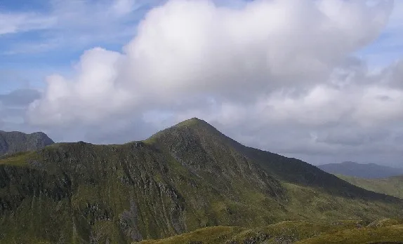
Ben Vorlich Grinner at English Wikipedia · CC BY-SA 3.0

Climate of Beinn Fuath
This month · November
A wet month
Day 5° · Night 0° · Rain 188 mm
- Hottest month
- July (day 14°)
- Coldest month
- February (night -3°)
- Wettest month
- January (226 mm)
- Driest month
- April (88 mm)
Bars: average monthly low and high temperature. Below: precipitation. Monthly averages for 1970–2000 at about 18 km resolution, adjusted for elevation. Highlighted months are mild and relatively dry. Source: WorldClim 2.1 (CC BY 4.0).
Show values as a table
| Month | Jan | Feb | Mar | Apr | May | Jun | Jul | Aug | Sep | Oct | Nov | Dec |
|---|---|---|---|---|---|---|---|---|---|---|---|---|
| Average high (°C) | 2° | 3° | 4° | 7° | 10° | 13° | 14° | 14° | 11° | 8° | 5° | 3° |
| Average low (°C) | -2° | -3° | -2° | 0° | 2° | 5° | 7° | 7° | 5° | 3° | 0° | -2° |
| Precipitation (mm) | 226 | 146 | 157 | 88 | 98 | 91 | 99 | 116 | 158 | 192 | 188 | 194 |
How to get to Beinn Fuath
The nearest airport is Glasgow Airport (GLA), 59 km to the south as the crow flies. The nearest large city is Glasgow, 57 km to the south.
Airports
- Glasgow Airport (GLA) Glasgow 59 kmsouth
- Edinburgh Airport (EDI) Ingliston, Edinburgh 66 kmsoutheast
- Dundee Airport (DND) Dundee 68 kmeast
Nearby large cities
- Glasgow Population: 626.4K 57 kmsouth
- Dundee Population: 148.2K 72 kmeast
- Edinburgh Population: 515K 74 kmsoutheast
- Aberdeen Population: 198.6K 151 kmnortheast
- Newcastle upon Tyne Population: 300.1K 221 kmsoutheast
Straight-line distances; road distances are longer. Airport data: OurAirports.
Day trips from Beinn Fuath
Within 100 km: 190 historic and cultural sites, 4,086 natural sites, 1,108 lakes, rivers and coasts.
0–25 km354 places
- Ellens Isle Island 25 kmSW
- Garbh Innis Island 24 kmSW
- Isle of Spar Island 25 kmN
- An t-Eilean Island 2 kmN
25–60 km1,525 places
- Mugdrum Island Island 54 kmE
- Inishail Island 59 kmW
- Inchlonaig Island 43 kmSW
- Inchcailloch Island 42 kmSW
60–100 km3,505 places
- Great Cumbrae Island Island 84 kmSW
- Troon Beach Beach 98 kmS
- Hunterston Sands Beach 86 kmSW
- Burntisland Beach Beach 65 kmSE
Straight-line distances.
Nearest towns and villages
-
Saint Fillans Village, Perth and Kinross1.5 km N
-
Comrie Village, Perth and Kinross8.8 km E
-
Dunira Village, Perth and Kinross5.6 km E
-
Ardvorlich Village, Perth and Kinross6 km W
-
Tullybannocher Village, Perth and Kinross6.6 km E
-
Dalclathick Village, Perth and Kinross6.8 km SE
Nearby attractions & nature
Everything nearby-
Am Bioran Mountain, Perth and Kinross0.5 km NE
-
Leacan Dubha Mountain, Perth and Kinross1 km W
-
Meall nan Saighdearan Mountain, Perth and Kinross2 km W
-
Dundurn Hill Mountain, Perth and Kinross2.1 km NE
-
Beinn Dearg Mountain, Perth and Kinross2.1 km S
-
Cnoc a' Mhadaidh Mountain, Perth and Kinross2.2 km N
-
St Fillan's Hill Mountain, Perth and Kinross2.2 km NE
-
Mor Bheinn Mountain, Perth and Kinross2.6 km E
Sources & licences
Data last updated: