Meall nam Fiadh Far East Top
Located in Perth and Kinross, Scotland Coordinates: 56°25′10″ N 4°05′46″ W
- Elevation
- 619 m
- above sea level
- Local time
- UTC+00:00
- Europe/London · UTC+00:00
- Airports
- GLA Glasgow Airport64 km
- DND Dundee Airport66 km
About Meall nam Fiadh Far East Top
Meall nam Fiadh Far East Top is a mountain. Location: Perth and Kinross, Scotland. Elevation: 619 m. The nearest airport is Glasgow Airport (64 km). Nearby sights include Wester Top and Meall nam Fiadh.
Photos of Meall nam Fiadh Far East Top
-
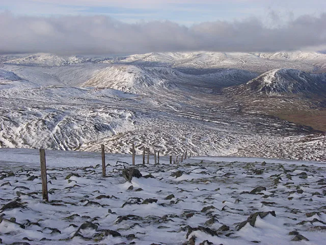
Ben Chonzie Andrew Smith · CC BY-SA 2.0

Climate of Meall nam Fiadh Far East Top
This month · November
A wet month
Day 5° · Night 0° · Rain 188 mm
- Hottest month
- July (day 14°)
- Coldest month
- February (night -2°)
- Wettest month
- January (226 mm)
- Driest month
- April (88 mm)
Bars: average monthly low and high temperature. Below: precipitation. Monthly averages for 1970–2000 at about 18 km resolution, adjusted for elevation. Highlighted months are mild and relatively dry. Source: WorldClim 2.1 (CC BY 4.0).
Show values as a table
| Month | Jan | Feb | Mar | Apr | May | Jun | Jul | Aug | Sep | Oct | Nov | Dec |
|---|---|---|---|---|---|---|---|---|---|---|---|---|
| Average high (°C) | 3° | 3° | 4° | 7° | 10° | 13° | 14° | 14° | 12° | 8° | 5° | 3° |
| Average low (°C) | -2° | -2° | -2° | 0° | 3° | 5° | 7° | 7° | 6° | 3° | 0° | -2° |
| Precipitation (mm) | 226 | 146 | 157 | 88 | 98 | 91 | 99 | 116 | 158 | 192 | 188 | 194 |
How to get to Meall nam Fiadh Far East Top
The nearest airport is Glasgow Airport (GLA), 64 km to the south as the crow flies. The nearest large city is Glasgow, 63 km to the south.
Airports
- Glasgow Airport (GLA) Glasgow 64 kmsouth
- Dundee Airport (DND) Dundee 66 kmeast
- Edinburgh Airport (EDI) Ingliston, Edinburgh 69 kmsoutheast
Nearby large cities
- Glasgow Population: 626.4K 63 kmsouth
- Dundee Population: 148.2K 69 kmeast
- Edinburgh Population: 515K 76 kmsoutheast
- Aberdeen Population: 198.6K 146 kmnortheast
- Newcastle upon Tyne Population: 300.1K 224 kmsoutheast
Straight-line distances; road distances are longer. Airport data: OurAirports.
Day trips from Meall nam Fiadh Far East Top
Within 100 km: 190 historic and cultural sites, 4,166 natural sites, 1,093 lakes, rivers and coasts.
0–25 km357 places
- Isle of Spar Island 19 kmN
- Eilean nan Ubh Island 22 kmN
- An t-Eilean Island 3 kmS
- Eilean nam Breaban Island 11 kmNW
25–60 km1,541 places
- Mugdrum Island Island 53 kmE
- Inchlonaig Island 48 kmSW
- Inchcailloch Island 47 kmSW
- Fraoch Eilean Island 59 kmW
60–100 km3,551 places
- Great Cumbrae Island Island 89 kmSW
- Hunterston Sands Beach 92 kmSW
- Burntisland Beach Beach 67 kmSE
- Cramond beach Beach 70 kmSE
Straight-line distances.
Nearest towns and villages
-
Invergeldie Village, Perth and Kinross3.3 km E
-
Saint Fillans Village, Perth and Kinross4.2 km S
-
Dunira Village, Perth and Kinross5.6 km SE
-
Comrie Village, Perth and Kinross9.2 km SE
-
Carroglen Village, Perth and Kinross6.1 km E
-
Tullybannocher Village, Perth and Kinross7.2 km SE
Nearby attractions & nature
Everything nearby-
Wester Top Mountain, Perth and Kinross1.5 km E
-
Meall nam Fiadh Mountain, Perth and Kinross1.7 km W
-
Creag Odhar Mountain, Perth and Kinross1.7 km W
-
The Girron Mountain, Perth and Kinross1.8 km SW
-
Creag Bhuidhe Mountain, Perth and Kinross2.4 km S
-
Balnacoul Castle Mountain, Perth and Kinross2.5 km SE
-
Spout Rolla Natural site, Perth and Kinross2.4 km NE
-
Loch Boltachan Lake, Perth and Kinross2.2 km S
Sources & licences
Data last updated: