- Elevation
- 44 m
- above sea level
- Local time
- UTC+00:00
- Europe/London · UTC+00:00
- Airports
- LSI Sumburgh Airport9 km
- EOI Eday Airport117 km
About Ward of Colsay
Ward of Colsay is an island. Location: Shetland Islands, Scotland. The nearest airport is Sumburgh Airport (9 km). Nearby sights include Colsay Island and Stack of Whalegeo.
Photos of Ward of Colsay
-
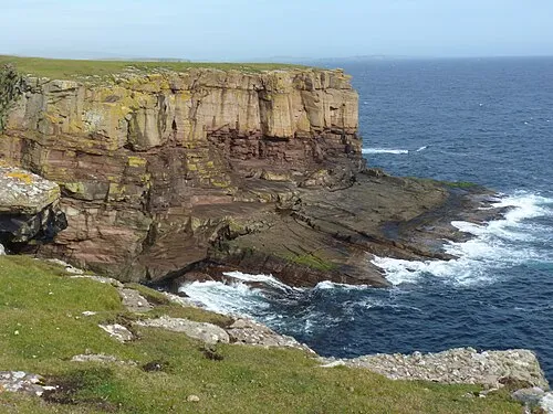
Lambhoga Head Derek Mayes · CC BY-SA 2.0

Climate of Ward of Colsay
This month · November
A wet month
Day 9° · Night 4° · Rain 144 mm
- Hottest month
- August (day 15°)
- Coldest month
- February (night 2°)
- Wettest month
- November (144 mm)
- Driest month
- May (49 mm)
Bars: average monthly low and high temperature. Below: precipitation. Monthly averages for 1970–2000 at about 18 km resolution, adjusted for elevation. Highlighted months are mild and relatively dry. Source: WorldClim 2.1 (CC BY 4.0).
Show values as a table
| Month | Jan | Feb | Mar | Apr | May | Jun | Jul | Aug | Sep | Oct | Nov | Dec |
|---|---|---|---|---|---|---|---|---|---|---|---|---|
| Average high (°C) | 6° | 6° | 7° | 8° | 11° | 13° | 14° | 15° | 13° | 11° | 9° | 7° |
| Average low (°C) | 2° | 2° | 2° | 3° | 5° | 8° | 9° | 10° | 8° | 7° | 4° | 3° |
| Precipitation (mm) | 128 | 103 | 115 | 72 | 49 | 55 | 57 | 74 | 110 | 128 | 144 | 137 |
How to get to Ward of Colsay
The nearest airport is Sumburgh Airport (LSI), 9 km to the southeast as the crow flies. The nearest large city is Aberdeen, 316 km to the south.
Airports
- Sumburgh Airport (LSI) Lerwick, Shetland 9 kmsoutheast
- Eday Airport (EOI) Eday 117 kmsouthwest
- Kirkwall Airport (KOI) Kirkwall, Orkney Islands 141 kmsouthwest
Nearby large cities
- Aberdeen Population: 198.6K 316 kmsouth
- Bergen Population: 294K 374 kmeast
- Dundee Population: 148.2K 399 kmsouth
Straight-line distances; road distances are longer. Airport data: OurAirports.
Day trips from Ward of Colsay
Within 100 km: 15 historic and cultural sites, 607 natural sites, 262 lakes, rivers and coasts.
0–25 km160 places
- Trondra Island 19 kmN
- Sweyn Holm Island 2 kmN
- Green Holm Island 20 kmN
- West Burra Island Island 14 kmN
25–60 km451 places
- Shetland Islands Island 42 kmN
- Whalsay Island 47 kmNE
- The Quey Island 59 kmN
- South Benelip Island 59 kmNE
60–100 km273 places
- Unst Island 93 kmN
- Fetlar Island Island 79 kmN
- The Vere Island 90 kmN
- The Vere Island 89 kmN
Straight-line distances.
Nearest towns and villages
-
Rerwick Village, Shetland Islands1.8 km NE
-
Scousburgh Village, Shetland Islands1.8 km E
-
Noss Village, Shetland Islands2.1 km S
-
South Scousburgh Village, Shetland Islands2.4 km SE
-
Bigton Village, Shetland Islands3 km NE
-
Cannygates Village, Shetland Islands3.7 km NE
Nearby attractions & nature
Everything nearby-
Colsay Island Island, Shetland Islands0.3 km E
-
Stack of Whalegeo Mountain, Shetland Islands1.2 km S
-
Gilden's Get Mountain, Shetland Islands1.3 km S
-
Bay of Scousburgh Natural site, Shetland Islands1.3 km E
-
Grey Noup Natural site, Shetland Islands2 km S
-
Goodmans Stack Mountain, Shetland Islands1.7 km S
-
Saint Ninian’s Bay Natural site, Shetland Islands1.8 km N
-
Noup o' Noss Mountain, Shetland Islands2 km S
Sources & licences
Data last updated: