- Elevation
- 77 m
- above sea level
- Airports
- SYY Stornoway Airport49 km
- BEB Benbecula Airport68 km
About Druim na Sgatha
Druim na Sgatha is an island. Location: Western Isles, Scotland. The nearest airport is Stornoway Airport (49 km). Nearby sights include Mealasta Island and Greineim Island.
Photos of Druim na Sgatha
-
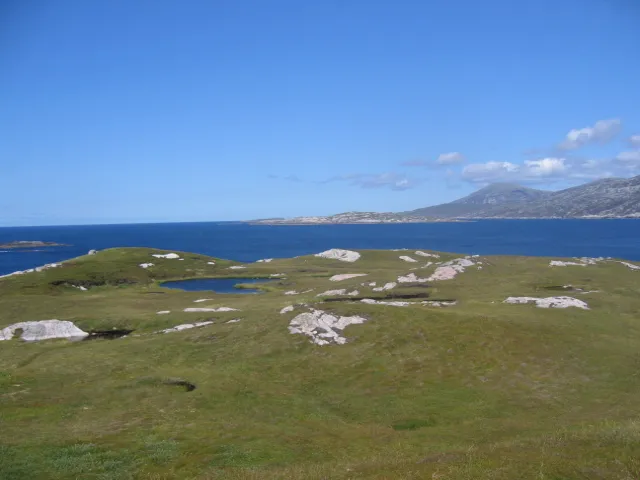
Kearstay JJM · CC BY-SA 2.0

Climate of Druim na Sgatha
This month · November
A wet month
Day 9° · Night 4° · Rain 176 mm
- Hottest month
- August (day 15°)
- Coldest month
- February (night 2°)
- Wettest month
- October (177 mm)
- Driest month
- May (73 mm)
Bars: average monthly low and high temperature. Below: precipitation. Monthly averages for 1970–2000 at about 18 km resolution, adjusted for elevation. Highlighted months are mild and relatively dry. Source: WorldClim 2.1 (CC BY 4.0).
Show values as a table
| Month | Jan | Feb | Mar | Apr | May | Jun | Jul | Aug | Sep | Oct | Nov | Dec |
|---|---|---|---|---|---|---|---|---|---|---|---|---|
| Average high (°C) | 7° | 7° | 7° | 9° | 12° | 13° | 15° | 15° | 14° | 11° | 9° | 7° |
| Average low (°C) | 2° | 2° | 3° | 4° | 6° | 9° | 10° | 11° | 9° | 7° | 4° | 3° |
| Precipitation (mm) | 167 | 127 | 140 | 86 | 73 | 80 | 94 | 107 | 147 | 177 | 176 | 168 |
How to get to Druim na Sgatha
The nearest airport is Stornoway Airport (SYY), 49 km to the east as the crow flies. The nearest large city is Glasgow, 302 km to the southeast.
Airports
- Stornoway Airport (SYY) Stornoway, Western Isles 49 kmeast
- Benbecula Airport (BEB) Balivanich 68 kmsouth
- Barra Airport (BRR) Eoligarry 119 kmsouth
Nearby large cities
- Glasgow Population: 626.4K 302 kmsoutheast
- Dundee Population: 148.2K 308 kmsoutheast
- Aberdeen Population: 198.6K 318 kmeast
- Edinburgh Population: 515K 336 kmsoutheast
- Belfast Population: 348K 395 kmsouth
Straight-line distances; road distances are longer. Airport data: OurAirports.
Day trips from Druim na Sgatha
Within 100 km: 20 historic and cultural sites, 984 natural sites, 884 lakes, rivers and coasts.
0–25 km302 places
- Gousam Island 18 kmNE
- Tearbaso Island 21 kmNE
- Cròcach Island 21 kmNE
- Soay Mór Island 19 kmSE
25–60 km741 places
- Isle of Harris Natural site 28 kmSE
- Dalmore Beach Beach 34 kmNE
- Dailbeag Beach Beach 35 kmNE
- Scalpay Island 36 kmSE
60–100 km845 places
- Island of Raasay Island 100 kmSE
- The Coral Beaches Beach 70 kmSE
- Clett Island 68 kmSE
- Eilean a' Char Island 100 kmE
Straight-line distances.
Nearest towns and villages
Nearby attractions & nature
Everything nearby-
Mealasta Island Island, Western Isles0.8 km N
-
Greineim Island Island, Western Isles2.6 km N
-
Liongam Island, Western Isles2.3 km SE
-
Aonaig Mhor Tamna Siar Mountain, Western Isles3.1 km E
-
Mocleitean Mountain, Western Isles3.3 km E
-
Griomaval Mountain, Western Isles3.5 km E
-
Grèineam Island, Western Isles3.3 km N
-
Aird Mhor Mill Tamna Mountain, Western Isles3.9 km E
More lakes, rivers and coasts in United Kingdom
-
Kearstay Island, Western Isles5 km S
-
Oisteim Island, Western Isles4.4 km S
-
Scarp Island, Western Isles4.8 km S
-
Sron Romul Island, Western Isles5.5 km S
-
Fladaigh Island, Western Isles6.2 km S
-
Grèine Sgeir Island, Western Isles6.4 km SE
Sources & licences
Data last updated: