Limburg Province
Local name: Belsj Limburg
Located in Flemish Region, Belgium Coordinates: 51°00′00″ N 5°30′00″ E

- Population
- 900,098
- 900.1K
- Elevation
- 77 m
- above sea level
- Local time
- UTC+01:00
- Europe/Brussels · UTC+01:00
- Places inside
- 226
- listed under Limburg Province
- Airports
- MST Maastricht Aachen Airport21 km
- LGG Liège Airport40 km
About Limburg Province
Limburg Province is a district. Location: Flemish Region, Belgium. Population: 900,098.
Limburg (Dutch: Limburg, pronounced [ˈlɪmbʏr(ə)x] ; Limburgish: Limburg [ˈlɪm˦ˌbʏʀ˦əx] or Wes-Limburg [wæsˈlɪm˦ˌbʏʀ˦əx]; French: Limbourg, pronounced [lɛ̃buʁ] ), also known as Belgian Limburg, is a province in Belgium. It is the easternmost of the five Dutch-speaking provinces that together form the Region of Flanders, which is one of the three main political and cultural sub-divisions of modern-day Belgium. As of January 2024, Limburg had a population of 0.9 million.
Source: Wikipedia · CC BY-SA 4.0
Travel notes for Limburg Province
From Wikivoyage
Limburg is one of the five provinces of Flanders (Belgium). There is also a province called Limburg in The Netherlands. It is the easternmost province of Flanders. The province boasts an interesting mining history, forests and historic towns. The area is mainly visited by tourists from Belgium or its neighbouring countries.
Understand+
Whereas much of Flanders is built-up, cosmopolitan, and frenetic, the Belgian Limburg is more rural and down-to-earth.
Source: Wikivoyage · CC BY-SA 4.0 · abridged
Places bordering Limburg Province
Population of Limburg Province over time
| 2016 | 860,204 | |
|---|---|---|
| 2018 | 870,880 | |
| 2024 | 900,098 | |
| 2025 | 904,919 |
Censuses and official estimates; source: Wikidata.
Climate of Limburg Province
Best months for sightseeingBest months for sightseeing: June–August.
This month · November
A cold month
Day 9° · Night 3° · Rain 69 mm
- Hottest month
- August (day 23°)
- Coldest month
- February (night 0°)
- Wettest month
- June (77 mm)
- Driest month
- April (51 mm)
Bars: average monthly low and high temperature. Below: precipitation. Monthly averages for 1970–2000 at about 18 km resolution, adjusted for elevation. Highlighted months are mild and relatively dry. Source: WorldClim 2.1 (CC BY 4.0).
Show values as a table
| Month | Jan | Feb | Mar | Apr | May | Jun | Jul | Aug | Sep | Oct | Nov | Dec |
|---|---|---|---|---|---|---|---|---|---|---|---|---|
| Average high (°C) | 5° | 6° | 10° | 13° | 18° | 21° | 23° | 23° | 19° | 14° | 9° | 6° |
| Average low (°C) | 0° | 0° | 2° | 4° | 8° | 11° | 13° | 12° | 10° | 7° | 3° | 1° |
| Precipitation (mm) | 60 | 52 | 62 | 51 | 65 | 77 | 74 | 67 | 62 | 64 | 69 | 71 |
How to get to Limburg Province
The nearest airport is Maastricht Aachen Airport (MST), 21 km to the southeast as the crow flies. The nearest large city is Maastricht, 21 km to the southeast.
Airports
- Maastricht Aachen Airport (MST) Maastricht 21 kmsoutheast
- Liège Airport (LGG) Grâce-Hollogne 40 kmsouth
- Eindhoven Airport (EIN) Eindhoven 51 kmnorth
Nearby large cities
- Maastricht Population: 122.4K 21 kmsoutheast
- Liège Population: 195.3K 41 kmsouth
- Aachen Population: 265.2K 48 kmsoutheast
- Eindhoven Population: 235.7K 49 kmnorth
- Leuven Population: 101K 58 kmwest
Straight-line distances; road distances are longer. Airport data: OurAirports.
Day trips from Limburg Province
Within 100 km: 389 historic and cultural sites, 1,201 natural sites, 935 lakes, rivers and coasts.
0–25 km191 places
- Schemersberg Mountain 4 kmSW
- Sacramentsberg Mountain 16 kmW
- Kaaienberg Mountain 16 kmW
- Zusterkloosterbos Natural site 20 kmSW
25–60 km575 places
- Île du Moulin Island 49 kmS
- Île Monsin Island 39 kmS
- Île de Franche Garenne Island 36 kmS
- Speelberg Mountain 51 kmW
60–100 km1,759 places
- Mont de la Tour de Coo Mountain 72 kmS
- Steiner Berg Mountain 90 kmSE
- Schartenknopf Mountain 98 kmSE
- Roderhöhe Mountain 81 kmSE
Straight-line distances.
Places in Limburg Province
226 placesCities & villages2
- Trommelveld · Village
- Vijverbroek · Village
Mountains & nature9
- Solter Heide · Natural site
- Stelebos · Natural site
- Sterrebos · Natural site
- Stokkemderbos · Natural site
- Varkensbos · Natural site
- Veldhoven Bos · Natural site
- Vogelzangbos · Natural site
- Weirkensebergen · Natural site
- Zusterkloosterbos · Natural site
Lakes, rivers & coasts35
- Soerbeek · River
- Sonnisbeek · River
- Sterrebeek · River
- Stiemer · River
- Tapziep · River
- Terbermenbeek · River
- Tettelbeek · River
- Vloetgracht · River
- Vlootgracht · River
- Voortbeek · River
- Voortbeek · River
- Vossenkot · River
- Vrietselbeek · River
- Waanbeek · River
- Warmbeek · River
- Weerterbeek · River
- Weeterbeek · River
- Weierbeek · River
- Weierkenbeek · River
- Wiemerbeek · River
- Wilderbeek · River
- Windhalm Beek · River
- Winterbeek · River
- Winterbeek · River
- Winterbeek · River
- Winterbeek · River
- Winterbeek · River
- Winterbeek · River
- Winterbeek · River
- Witbeek · River
- Zanderbeek · River
- Ziepbeek · River
- Zusterkloosterbeek · River
- Zwarte Winterbeek · River
- Zwart Water · River
Nature and heritage in Limburg Province
Nearby attractions & nature
Everything nearby-
Sint-Martensgracht River, Liège Province11 km S
-
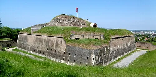 Saint Peter Fort Historic site, Maastricht Municipality22 km SE
-
Asbeek River, Belgium16 km SE
-
Gueule River, Belgium19 km SE
Sources & licences
Data last updated: · 2 independent sources