Arrondissement of Arras
Located in Pas-de-Calais, Hauts-de-France Coordinates: 50°16′03″ N 2°37′30″ E
- Population
- 249,836
- 249.8K
- Elevation
- 124 m
- above sea level
- Local time
- UTC+01:00
- Europe/Paris · UTC+01:00
- Places inside
- 357
- listed under Arrondissement of Arras
- Airports
- LIL Lille Airport48 km
- BVA Beauvais-Tillé airport98 km
About Arrondissement of Arras
Arrondissement of Arras is a municipality. Location: Pas-de-Calais, Hauts-de-France. Population: 249,836. Elevation: 124 m. The best months to visit are July–August. The nearest airport is Lille Airport (48 km). Nearby sights include Bois d'Habarcq and Canadian National Vimy Memorial.
Climate of Arrondissement of Arras
Best months for sightseeingBest months for sightseeing: July–August.
This month · November
A cold month
Day 9° · Night 4° · Rain 71 mm
- Hottest month
- August (day 22°)
- Coldest month
- February (night 1°)
- Wettest month
- November (71 mm)
- Driest month
- February (47 mm)
Bars: average monthly low and high temperature. Below: precipitation. Monthly averages for 1970–2000 at about 18 km resolution, adjusted for elevation. Highlighted months are mild and relatively dry. Source: WorldClim 2.1 (CC BY 4.0).
Show values as a table
| Month | Jan | Feb | Mar | Apr | May | Jun | Jul | Aug | Sep | Oct | Nov | Dec |
|---|---|---|---|---|---|---|---|---|---|---|---|---|
| Average high (°C) | 5° | 6° | 9° | 12° | 16° | 19° | 21° | 22° | 19° | 14° | 9° | 6° |
| Average low (°C) | 1° | 1° | 3° | 4° | 8° | 10° | 12° | 12° | 10° | 7° | 4° | 2° |
| Precipitation (mm) | 58 | 47 | 54 | 49 | 58 | 64 | 58 | 54 | 65 | 67 | 71 | 68 |
How to get to Arrondissement of Arras
The nearest airport is Lille Airport (LIL), 48 km to the northeast as the crow flies. The nearest large city is Amiens, 47 km to the southwest.
Airports
- Lille Airport (LIL) Lesquin 48 kmnortheast
- Beauvais-Tillé airport (BVA) Beauvais 98 kmsouth
- Ostend-Bruges International Airport (OST) Oostende 105 kmnorth
Nearby large cities
- Amiens Population: 143.1K 47 kmsouthwest
- Lille Population: 238.7K 51 kmnortheast
- Bruges Population: 118.5K 113 kmnorth
- Ghent Population: 265.1K 116 kmnortheast
- Charleroi Population: 200.1K 131 kmeast
Straight-line distances; road distances are longer. Airport data: OurAirports.
Day trips from Arrondissement of Arras
Within 100 km: 195 historic and cultural sites, 217 natural sites, 315 lakes, rivers and coasts.
0–25 km13 places
- Bois de Watron Natural site 16 kmSW
- Bois d'Habarcq Natural site 7 kmN
- Parc du chàteau Natural site 24 kmNW
- Gy River 8 kmNE
25–60 km165 places
- Rode Berg Mountain 58 kmN
- Kemmelberg Mountain 59 kmN
- Bois de Rongy Natural site 59 kmNE
- Bois de Ploegsteert Natural site 56 kmN
60–100 km549 places
- Plage Saint-Gabriel Beach 81 kmNW
- Plage de Fort-Mahon Beach 77 kmW
- Blankaart Lake 81 kmN
- Lac des Herbieres Lake 86 kmE
Straight-line distances.
Arrondissement of Arras and similar cities
Side by side with cities of similar size in the same country: population, elevation and climate.
| Measure | Arrondissement of Arras | Montpellier | Lille | Bordeaux |
|---|---|---|---|---|
| Population | 249.8K | 248.3K | 238.7K | 265.3K |
| Elevation | 124 m | 55 m | 20 m | 20 m |
| Summer day (hottest month) | 22° | 29° | 23° | 26° |
| Winter night (coldest month) | 1° | 3° | 1° | 2° |
| Annual rainfall | 713 mm | 645 mm | 716 mm | 921 mm |
| Best months | Jul–Aug | May–Oct | Jun–Aug | May–Sep |
| Distance | — | 746 km | 51 km | 650 km |
Climate values are 1970–2000 monthly averages; straight-line distance.
Places in Arrondissement of Arras
357 places- 121 Haute-Avesnes 450
- 122 Plouvain 450
- 123 Étaing 444
- 124 Foncquevillers 442
- 125 Saint-Léger 439
- 126 Ytres 435
- 127 Boiry-Becquerelle 433
- 128 Cagnicourt 432
- 129 Bailleul-lès-Pernes 430
- 130 Grand-Rullecourt 422
- 131 Ransart 411
- 132 Oppy 407
- 133 Boiry-Sainte-Rictrude 404
- 134 Ervillers 403
- 135 Orville 403
- 136 Havrincourt 401
- 137 Le Transloy 401
- 138 Beaufort-Blavincourt 399
- 139 Écurie 392
- 140 Beugny 386
- 141 Fiefs 384
- 142 Rémy 383
- 143 Bavincourt 382
- 144 Beauvoir-Wavans 382
- 145 Warlus 376
- 146 Frévin-Capelle 375
- 147 Souastre 375
- 148 Ramecourt 374
- 149 Sus-Saint-Léger 374
- 150 Grévillers 365
- 151 Sauchy-Cauchy 365
- 152 Villers-Brûlin 365
- 153 Bihucourt 357
- 154 Boyelles 357
- 155 Dury 344
- 156 Sachin 344
- 157 Guémappe 341
- 158 Cambligneul 339
- 159 Lagnicourt-Marcel 335
- 160 Ayette 326
- 161 Gouy-en-Artois 326
- 162 Croix-en-Ternois 324
- 163 Pronville-en-Artois 324
- 164 Sains-lès-Marquion 319
- 165 Hauteville 318
- 166 Étrun 317
- 167 Mory 315
- 168 Pressy 315
- 169 Hendecourt-lès-Cagnicourt 314
- 170 Blairville 312
- 171 Pommera 311
- 172 Sailly-au-Bois 307
- 173 Barastre 306
- 174 Monchy-Cayeux 306
- 175 Douchy-lès-Ayette 304
- 176 Amplier 303
- 177 Ruyaulcourt 302
- 178 Achiet-le-Petit 299
- 179 Chérisy 295
- 180 Brias 292
Bar: population relative to the most populous place in this list.
Nearby attractions & nature
Everything nearby-
Bois d'Habarcq Natural site, Hauts-de-France6.5 km N
-
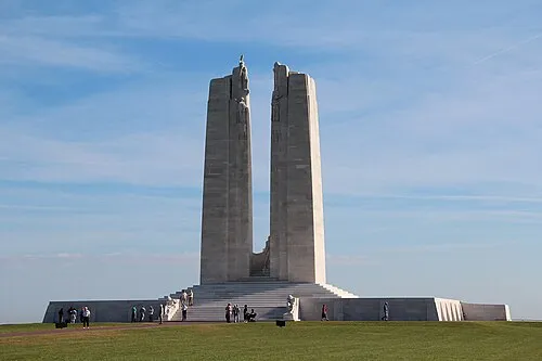 Canadian National Vimy Memorial Landmark, Givenchy-en-Gohelle16 km NE
-
Gy River, Hauts-de-France8 km NE
-
Crinchon River, Hauts-de-France10 km E
-
Cojeul River, Hauts-de-France12 km SE
-
Bois de Watron Natural site, Somme16 km SW
-
Bouvigny-Boyeffles TV Mast Landmark, Bouvigny-Boyeffles17 km N
-
Doullens Concentration Camp (SS-Baubrigade V) Historic site, Doullens24 km SW
Sources & licences
Data last updated: