Arrondissement of Arras
Located in Pas-de-Calais, Hauts-de-France Coordinates: 50°16′03″ N 2°37′30″ E
- Population
- 249,836
- 249.8K
- Elevation
- 124 m
- above sea level
- Local time
- UTC+01:00
- Europe/Paris · UTC+01:00
- Places inside
- 357
- listed under Arrondissement of Arras
- Airports
- LIL Lille Airport48 km
- BVA Beauvais-Tillé airport98 km
About Arrondissement of Arras
Arrondissement of Arras is a municipality. Location: Pas-de-Calais, Hauts-de-France. Population: 249,836. Elevation: 124 m. The best months to visit are July–August. The nearest airport is Lille Airport (48 km). Nearby sights include Bois d'Habarcq and Canadian National Vimy Memorial.
Climate of Arrondissement of Arras
Best months for sightseeingBest months for sightseeing: July–August.
This month · November
A cold month
Day 9° · Night 4° · Rain 71 mm
- Hottest month
- August (day 22°)
- Coldest month
- February (night 1°)
- Wettest month
- November (71 mm)
- Driest month
- February (47 mm)
Bars: average monthly low and high temperature. Below: precipitation. Monthly averages for 1970–2000 at about 18 km resolution, adjusted for elevation. Highlighted months are mild and relatively dry. Source: WorldClim 2.1 (CC BY 4.0).
Show values as a table
| Month | Jan | Feb | Mar | Apr | May | Jun | Jul | Aug | Sep | Oct | Nov | Dec |
|---|---|---|---|---|---|---|---|---|---|---|---|---|
| Average high (°C) | 5° | 6° | 9° | 12° | 16° | 19° | 21° | 22° | 19° | 14° | 9° | 6° |
| Average low (°C) | 1° | 1° | 3° | 4° | 8° | 10° | 12° | 12° | 10° | 7° | 4° | 2° |
| Precipitation (mm) | 58 | 47 | 54 | 49 | 58 | 64 | 58 | 54 | 65 | 67 | 71 | 68 |
How to get to Arrondissement of Arras
The nearest airport is Lille Airport (LIL), 48 km to the northeast as the crow flies. The nearest large city is Amiens, 47 km to the southwest.
Airports
- Lille Airport (LIL) Lesquin 48 kmnortheast
- Beauvais-Tillé airport (BVA) Beauvais 98 kmsouth
- Ostend-Bruges International Airport (OST) Oostende 105 kmnorth
Nearby large cities
- Amiens Population: 143.1K 47 kmsouthwest
- Lille Population: 238.7K 51 kmnortheast
- Bruges Population: 118.5K 113 kmnorth
- Ghent Population: 265.1K 116 kmnortheast
- Charleroi Population: 200.1K 131 kmeast
Straight-line distances; road distances are longer. Airport data: OurAirports.
Day trips from Arrondissement of Arras
Within 100 km: 195 historic and cultural sites, 217 natural sites, 315 lakes, rivers and coasts.
0–25 km13 places
- Bois de Watron Natural site 16 kmSW
- Bois d'Habarcq Natural site 7 kmN
- Parc du chàteau Natural site 24 kmNW
- Gy River 8 kmNE
25–60 km165 places
- Rode Berg Mountain 58 kmN
- Kemmelberg Mountain 59 kmN
- Bois de Rongy Natural site 59 kmNE
- Bois de Ploegsteert Natural site 56 kmN
60–100 km549 places
- Plage Saint-Gabriel Beach 81 kmNW
- Plage de Fort-Mahon Beach 77 kmW
- Blankaart Lake 81 kmN
- Lac des Herbieres Lake 86 kmE
Straight-line distances.
Arrondissement of Arras and similar cities
Side by side with cities of similar size in the same country: population, elevation and climate.
| Measure | Arrondissement of Arras | Montpellier | Lille | Bordeaux |
|---|---|---|---|---|
| Population | 249.8K | 248.3K | 238.7K | 265.3K |
| Elevation | 124 m | 55 m | 20 m | 20 m |
| Summer day (hottest month) | 22° | 29° | 23° | 26° |
| Winter night (coldest month) | 1° | 3° | 1° | 2° |
| Annual rainfall | 713 mm | 645 mm | 716 mm | 921 mm |
| Best months | Jul–Aug | May–Oct | Jun–Aug | May–Sep |
| Distance | — | 746 km | 51 km | 650 km |
Climate values are 1970–2000 monthly averages; straight-line distance.
Places in Arrondissement of Arras
357 places- 241 Tilloy-lès-Hermaville 224
- 242 Barly 223
- 243 Hautecloque 219
- 244 Humbercamps 219
- 245 Bergueneuse 217
- 246 Fresnoy-en-Gohelle 217
- 247 Ablainzevelle 216
- 248 Bellonne 216
- 249 Récourt 216
- 250 Capelle-Fermont 215
- 251 Conchy-sur-Canche 213
- 252 Fortel-en-Artois 212
- 253 Saint-Martin-sur-Cojeul 210
- 254 La Cauchie 206
- 255 Morchies 206
- 256 Le Ponchel 203
- 257 Prédefin 199
- 258 Wavrans-sur-Ternoise 199
- 259 Gaudiempré 198
- 260 Hannescamps 198
- 261 Martinpuich 198
- 262 Aumerval 197
- 263 Gouves 197
- 264 Rebreuve-sur-Canche 197
- 265 Sapignies 196
- 266 Manin 189
- 267 Ligny-sur-Canche 188
- 268 Maizières 187
- 269 Haplincourt 186
- 270 Warlincourt-lès-Pas 186
- 271 Marquay 182
- 272 Sarton 182
- 273 Héninel 181
- 274 Trescault 181
- 275 Le Sars 179
- 276 Nœux-lès-Auxi 179
- 277 Buneville 178
- 278 Herlin-le-Sec 177
- 279 Humerœuille 174
- 280 Noyellette 173
- 281 Beugnâtre 170
- 282 Estrée-Wamin 169
- 283 Neuville-Bourjonval 169
- 284 Hénu 166
- 285 Bermicourt 162
- 286 Tilly-Capelle 162
- 287 Avesnes-lès-Bapaume 159
- 288 Noreuil 158
- 289 Foufflin-Ricametz 156
- 290 Le Souich 156
- 291 Linzeux 156
- 292 Nédon 154
- 293 Aubrometz 153
- 294 Gomiécourt 153
- 295 Béthonsart 151
- 296 Givenchy-le-Noble 151
- 297 La Herlière 148
- 298 Beauvois 144
- 299 Warlencourt-Eaucourt 143
- 300 Fosseux 140
Bar: population relative to the most populous place in this list.
Nearby attractions & nature
Everything nearby-
Bois d'Habarcq Natural site, Hauts-de-France6.5 km N
-
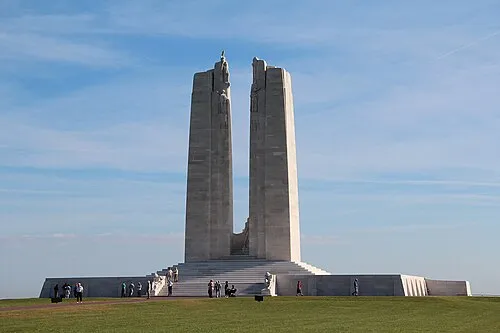 Canadian National Vimy Memorial Landmark, Givenchy-en-Gohelle16 km NE
-
Gy River, Hauts-de-France8 km NE
-
Crinchon River, Hauts-de-France10 km E
-
Cojeul River, Hauts-de-France12 km SE
-
Bois de Watron Natural site, Somme16 km SW
-
Bouvigny-Boyeffles TV Mast Landmark, Bouvigny-Boyeffles17 km N
-
Doullens Concentration Camp (SS-Baubrigade V) Historic site, Doullens24 km SW
Sources & licences
Data last updated: