Kalipado
Local name: Καλιπάδο
Located in Zakynthos, Nomós Zakýnthou Coordinates: 37°48′03″ N 20°50′16″ E
- Population
- 709
- 709
- Elevation
- 34 m
- above sea level
- Local time
- UTC+02:00
- Europe/Athens · UTC+02:00
- Airports
- ZTH Zakynthos International Airport "Dionysios Solomos"7 km
- EFL Kefalonia International Airport "Anna Pollatou"46 km
About Kalipado
Kalipado is a village. Location: Zakynthos, Nomós Zakýnthou. Population: 709. Elevation: 34 m.
Kalipado (Greek: Καλιπάδο) is a settlement on the island of Zakynthos of Greece. It is located 1 km (0.62 mi) northwest of Vanato and 5 km (3.1 mi) northwest of Zakynthos City. There is significant history attributed to the origins of this village in the area of Arkadioi, a municipal unit of the Southern Ionian Sea chain of islands that go from north, opposite Albania to the south, opposite the mid-Peloponesean southern coast of lower Greece.
Source: Wikipedia · CC BY-SA 4.0
Photos of Kalipado
-
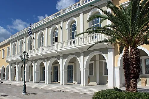
Byzantine Museum of Zakynthos Maesi64 · CC0

Population of Kalipado over time
| 1991 | 504 | |
|---|---|---|
| 2001 | 624 | |
| 2011 | 709 | |
| 2021 | 545 |
Censuses and official estimates; source: Wikidata.
Climate of Kalipado
Best months for sightseeingBest months for sightseeing: May.
This month · November
A wet month
Day 18° · Night 11° · Rain 153 mm
- Hottest month
- August (day 30°)
- Coldest month
- January (night 7°)
- Wettest month
- December (186 mm)
- Driest month
- July (6 mm)
Bars: average monthly low and high temperature. Below: precipitation. Monthly averages for 1970–2000 at about 18 km resolution, adjusted for elevation. Highlighted months are mild and relatively dry. Source: WorldClim 2.1 (CC BY 4.0).
Show values as a table
| Month | Jan | Feb | Mar | Apr | May | Jun | Jul | Aug | Sep | Oct | Nov | Dec |
|---|---|---|---|---|---|---|---|---|---|---|---|---|
| Average high (°C) | 14° | 14° | 16° | 19° | 23° | 27° | 30° | 30° | 27° | 23° | 18° | 15° |
| Average low (°C) | 7° | 7° | 8° | 11° | 14° | 18° | 20° | 21° | 18° | 15° | 11° | 9° |
| Precipitation (mm) | 148 | 104 | 86 | 49 | 21 | 8 | 6 | 9 | 36 | 129 | 153 | 186 |
Other places to visit in this season: May
How to get to Kalipado
The nearest airport is Zakynthos International Airport "Dionysios Solomos" (ZTH), 7 km to the southeast as the crow flies. The nearest large city is Piraeus, 248 km to the east.
Airports
- Zakynthos International Airport "Dionysios Solomos" (ZTH) Zakynthos 7 kmsoutheast
- Kefalonia International Airport "Anna Pollatou" (EFL) Kefallinia Island 46 kmnorthwest
- Patras Araxos Agamemnon Airport (GPA) Patras 65 kmnortheast
Nearby large cities
- Piraeus Population: 163.7K 248 kmeast
- Athens Population: 664K 255 kmeast
Straight-line distances; road distances are longer. Airport data: OurAirports.
Day trips from Kalipado
Within 100 km: 11 historic and cultural sites, 23 lakes, rivers and coasts.
0–25 km1 place
- Byzantine Museum of Zakynthos Museum 6 kmE
25–60 km9 places
- Kefalonia Island 55 kmNW
- Moni Agiou Andrea Attraction 44 kmNW
- Monastery of the Virgin Mary of Atros Attraction 41 kmN
- Saraki Island 39 kmN
60–100 km24 places
- Monastery of Kipoureon Attraction 62 kmNW
- Nisídes Falarídes Island 63 kmN
- Nisída Vasilikó Island 80 kmNE
- Skartsoubonisi Island 65 kmN
Straight-line distances.
Sources & licences
Data last updated: · 2 independent sources