- Population
- 22,853
- 22.9K
- Elevation
- 303 m
- above sea level
- Local time
- UTC+02:00
- Europe/Athens · UTC+02:00
- Places inside
- 76
- listed under Kalampaka
- Airports
- IOA Ioannina King Pyrrhus National Airport59 km
- KZI Kozani National Airport Filippos67 km
About Kalampaka
Kalampaka is a municipality. Location: Trikala, Thessaly. Population: 22,853. Elevation: 303 m. The best months to visit are May, October. The nearest airport is Ioannina King Pyrrhus National Airport (59 km).
Photos of Kalampaka
-
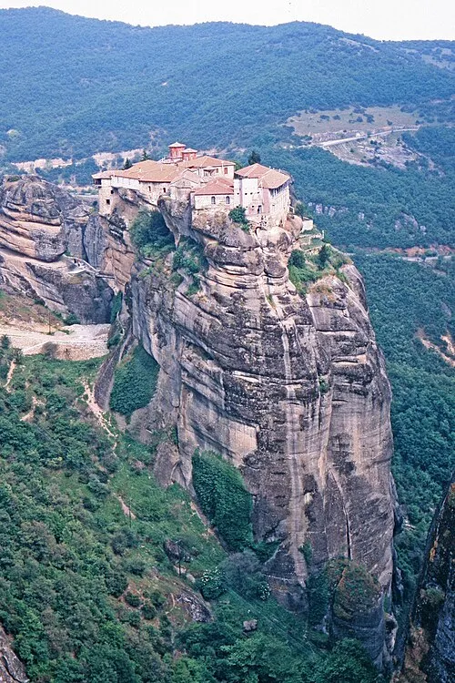
Meteora W. Bulach · CC BY-SA 4.0

Climate of Kalampaka
Best months for sightseeingBest months for sightseeing: May, October.
This month · November
Outside the best season
Day 15° · Night 6° · Rain 96 mm
- Hottest month
- July (day 32°)
- Coldest month
- January (night 1°)
- Wettest month
- November (96 mm)
- Driest month
- August (24 mm)
Bars: average monthly low and high temperature. Below: precipitation. Monthly averages for 1970–2000 at about 18 km resolution, adjusted for elevation. Highlighted months are mild and relatively dry. Source: WorldClim 2.1 (CC BY 4.0).
Show values as a table
| Month | Jan | Feb | Mar | Apr | May | Jun | Jul | Aug | Sep | Oct | Nov | Dec |
|---|---|---|---|---|---|---|---|---|---|---|---|---|
| Average high (°C) | 9° | 11° | 14° | 19° | 24° | 29° | 32° | 32° | 28° | 22° | 15° | 10° |
| Average low (°C) | 1° | 2° | 4° | 8° | 11° | 15° | 18° | 18° | 15° | 11° | 6° | 3° |
| Precipitation (mm) | 74 | 73 | 72 | 58 | 49 | 31 | 26 | 24 | 39 | 79 | 96 | 94 |
How to get to Kalampaka
The nearest airport is Ioannina King Pyrrhus National Airport (IOA), 59 km to the west as the crow flies. The nearest large city is Piraeus, 272 km to the southeast.
Airports
- Ioannina King Pyrrhus National Airport (IOA) Ioannina 59 kmwest
- Kozani National Airport Filippos (KZI) Kozani 67 kmnortheast
- Aktion National Airport (PVK) Preveza 111 kmsouthwest
Nearby large cities
- Piraeus Population: 163.7K 272 kmsoutheast
- Athens Population: 664K 273 kmsoutheast
- Sofia Population: 1.2M 362 kmnortheast
- Plovdiv Population: 329.5K 383 kmnortheast
Straight-line distances; road distances are longer. Airport data: OurAirports.
Day trips from Kalampaka
Within 100 km: 19 historic and cultural sites, 2 natural sites, 5 lakes, rivers and coasts.
0–25 km1 place
- Meteora Attraction 10 kmE
25–60 km6 places
- Moni Spilias Attraction 52 kmS
- Vounása Mountain 32 kmNE
- Moní Taxiarchón Attraction 49 kmN
- Aziz Aga bridge Landmark 31 kmNW
60–100 km19 places
- Moni Tatárnas Attraction 88 kmS
- Moní Agíon Anargyron Attraction 95 kmN
- Moni Retha Attraction 82 kmS
- Moni pantanassas Attraction 62 kmW
Straight-line distances.
Places in Kalampaka
76 places- 61 Mikani 95
- 62 Kraniá 94
- 63 Ágioi Theódoroi 82
- 64 Kerasoúla 81
- 65 Miliá 68
- 66 Stefáni 65
- 67 Koromiliá 49
- 68 Básia 48
- 69 Platanistós 48
- 70 Agía Triáda 43
- 71 Milótopos 40
- 72 Chalíki 38
- 73 Dolianá 35
- 74 Anthoúsa 10
- 75 Analipsi 4
Bar: population relative to the most populous place in this list.
Heritage & sights1
- Meteora · Attraction
Sources & licences
Data last updated: