An Da Chich Anann (An Chioch Thiar)
Located in County Kerry, Munster Coordinates: 52°00′55″ N 9°16′30″ W
- Elevation
- 690 m
- above sea level
- Local time
- UTC+00:00
- Europe/Dublin · UTC+00:00
- Airports
- KIR Kerry Airport25 km
- ORK Cork International Airport57 km
About An Da Chich Anann (An Chioch Thiar)
An Da Chich Anann (An Chioch Thiar) is a mountain. Location: County Kerry, Munster. Elevation: 690 m. The nearest airport is Kerry Airport (25 km). Nearby sights include An Da Chich Anann (An Chioch Thoir) and Lough Nageeha.
Photos of An Da Chich Anann (An Chioch Thiar)
-
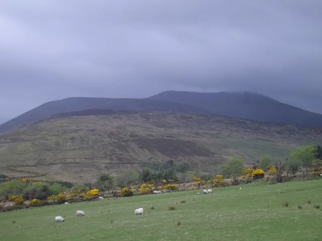
Derrynasaggart Mountains Keith Salvesen · CC BY-SA 2.0

Climate of An Da Chich Anann (An Chioch Thiar)
This month · November
A wet month
Day 7° · Night 2° · Rain 155 mm
- Hottest month
- July (day 15°)
- Coldest month
- January (night 0°)
- Wettest month
- December (169 mm)
- Driest month
- July (72 mm)
Bars: average monthly low and high temperature. Below: precipitation. Monthly averages for 1970–2000 at about 18 km resolution, adjusted for elevation. Highlighted months are mild and relatively dry. Source: WorldClim 2.1 (CC BY 4.0).
Show values as a table
| Month | Jan | Feb | Mar | Apr | May | Jun | Jul | Aug | Sep | Oct | Nov | Dec |
|---|---|---|---|---|---|---|---|---|---|---|---|---|
| Average high (°C) | 5° | 5° | 6° | 8° | 11° | 13° | 15° | 15° | 13° | 10° | 7° | 5° |
| Average low (°C) | 0° | 0° | 0° | 1° | 4° | 6° | 8° | 8° | 7° | 4° | 2° | 1° |
| Precipitation (mm) | 164 | 123 | 121 | 76 | 84 | 74 | 72 | 92 | 110 | 143 | 155 | 169 |
How to get to An Da Chich Anann (An Chioch Thiar)
The nearest airport is Kerry Airport (KIR), 25 km to the northwest as the crow flies. For international flights: Cork International Airport (ORK) (57 km). The nearest large city is Cork, 57 km to the east.
Airports
- Kerry Airport (KIR) Farranfore 25 kmnorthwest
- Cork International Airport (ORK) Cork 57 kmeast
- Shannon Airport (SNN) Shannon 80 kmnorth
Nearby large cities
- Cork Population: 224K 57 kmeast
- Limerick Population: 102.3K 85 kmnortheast
- Dublin Population: 1M 252 kmnortheast
- Belfast Population: 348K 364 kmnortheast
- Swansea Population: 300.4K 370 kmeast
Straight-line distances; road distances are longer. Airport data: OurAirports.
Day trips from An Da Chich Anann (An Chioch Thiar)
Within 100 km: 163 historic and cultural sites, 992 natural sites, 803 lakes, rivers and coasts.
0–25 km249 places
- Brown Island Island 20 kmW
- Ross Island Island 19 kmW
- Lamb Island Island 19 kmW
- Innisfallen Island 19 kmW
25–60 km867 places
- Banna Strand Beach 53 kmNW
- Inch beach Beach 49 kmW
- Rossbeigh Strand Beach 48 kmW
- Whiddy Island Island 39 kmSW
60–100 km842 places
- Valentia Island Island 76 kmW
- White Strand Beach 74 kmSW
- White Strand Beach 84 kmN
- Derrynane Beach Beach 65 kmSW
Straight-line distances.
Nearest towns and villages
-
Gortacareen Village, County Kerry2 km NW
-
Clydagh Bridge Village, County Kerry3.2 km SW
-
Gortnagane Village, County Kerry3.3 km NE
-
Annagh Village, County Kerry3.6 km W
-
Cloonkeen Village, County Kerry3.9 km SW
-
Cammeenavrick Village, County Kerry4.1 km SE
Nearby attractions & nature
Everything nearby-
An Da Chich Anann (An Chioch Thoir) Mountain, County Kerry0.8 km E
-
Lough Nageeha Lake, County Kerry0.7 km N
-
Killeen Mountain Mountain, County Kerry2.7 km W
-
Lough Glannatreaghaun Lake, County Kerry1.9 km E
-
Knocknabro West Top Mountain, County Kerry2.9 km E
-
Derrynasaggart Mountains Mountain, County Kerry4.6 km SE
-
Carrigaveema Mountain, County Kerry3.6 km SW
-
Beheenagh River River, County Kerry2 km E
Sources & licences
Data last updated: