Drung Hill
Located in County Kerry, Munster Coordinates: 52°01′30″ N 10°02′15″ W
- Elevation
- 640 m
- above sea level
- Local time
- UTC+00:00
- Europe/Dublin · UTC+00:00
About Drung Hill
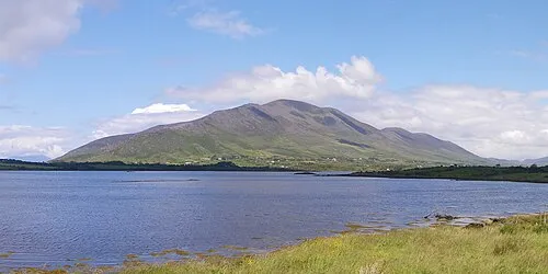
Drung Hill is a mountain. Location: County Kerry, Munster. Elevation: 640 m.
Drung Hill (Irish: Cnoc Droinge) is a hill on the Iveragh Peninsula of southwestern Ireland. Overlooking the Atlantic Ocean, its summit is 640 metres (2,100 ft) tall. Like the peak of Knocknadobar to the west, it has been a pilgrimage site since pre-Christian times.
Read more on Wikipedia Text: Wikipedia contributors · CC BY-SA 4.0 · shortened
In comparison
- No. 196 of 2106 mountains in Ireland by elevation
- 35 sights and natural places within 10 km Beenmore, Coomnacronia Lake
Nearest towns and villages
-
Kilkeehagh Village, County Kerry1.6 km NE
-
Kealduff Village, County Kerry2.7 km SE
-
Drom Village, County Kerry3.8 km E
-
Glenbeigh Village, County Kerry7.8 km NE
-
Ballynakilly Upper Village, County Kerry4.3 km E
-
Darby’s Bridge Village, County Kerry4.6 km W
Nearby attractions & nature
Everything nearby-
Beenmore Mountain, County Kerry1.3 km SW
-
Been Hill Mountain, County Kerry2.7 km SW
-
Mullaghnarakill Mountain, County Kerry2.8 km S
-
Coomnacronia Lake Lake, County Kerry1.9 km S
-
Knockboy Mountain, County Kerry2.3 km NE
-
Mountain Stage Mountain, County Kerry3.2 km NE
-
Mount Foley Mountain, County Kerry2.8 km W
-
Coomreagh Mountain, County Kerry3.5 km SE
More nature in Ireland
-
Knockatinna Mountain, County Kerry3.7 km NE
-
Coomacarrea Mountain, County Kerry5.4 km S
-
Teermoyle Mountain Mountain, County Kerry4.5 km S
-
 Knocknadobar Mountain, County Kerry10 km W
-
Meenteog Mountain, County Kerry6.3 km SE
-
Beenreagh Mountain, County Kerry6.4 km E
Sources & licences
Data last updated: · 2 independent sources