- Elevation
- 1,839 m
- above sea level
- Local time
- UTC+01:00
- Europe/Rome · UTC+01:00
- Airports
- TSF Treviso Airport82 km
- TRS Trieste Airport92 km
About Monte Dof
Monte Dof is a mountain. Location: Claut, Province of Pordenone. Elevation: 1,839 m. The nearest airport is Treviso Airport (82 km). Nearby sights include Monte Turlon and Val Settimana.
Photos of Monte Dof
-
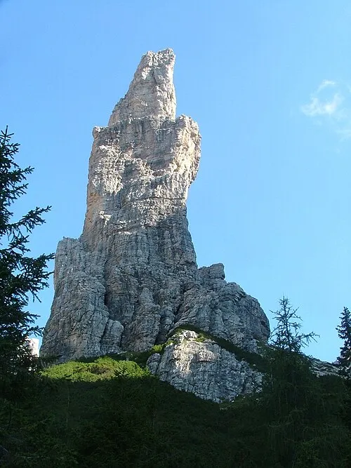
Campanile di Val Montanaia Antonio De Lorenzo · CC BY 2.5

Climate of Monte Dof
This month · November
A cold month
Day 2° · Night -5° · Rain 97 mm
- Hottest month
- July (day 16°)
- Coldest month
- January (night -9°)
- Wettest month
- July (145 mm)
- Driest month
- January (52 mm)
Bars: average monthly low and high temperature. Below: precipitation. Monthly averages for 1970–2000 at about 18 km resolution, adjusted for elevation. Highlighted months are mild and relatively dry. Source: WorldClim 2.1 (CC BY 4.0).
Show values as a table
| Month | Jan | Feb | Mar | Apr | May | Jun | Jul | Aug | Sep | Oct | Nov | Dec |
|---|---|---|---|---|---|---|---|---|---|---|---|---|
| Average high (°C) | -2° | -1° | 2° | 5° | 10° | 14° | 16° | 16° | 12° | 8° | 2° | -2° |
| Average low (°C) | -9° | -9° | -6° | -3° | 2° | 5° | 7° | 7° | 4° | 0° | -5° | -8° |
| Precipitation (mm) | 52 | 52 | 68 | 91 | 122 | 138 | 145 | 136 | 117 | 111 | 97 | 62 |
How to get to Monte Dof
The nearest airport is Treviso Airport (TSF), 82 km to the south as the crow flies. The nearest large city is Innsbruck, 134 km to the northwest.
Airports
- Treviso Airport (TSF) Treviso (TV) 82 kmsouth
- Trieste Airport (TRS) Ronchi dei Legionari/Trieste 92 kmsoutheast
- Bolzano Airport (BZO) Bolzano (BZ) 94 kmwest
Nearby large cities
- Innsbruck Population: 132.5K 134 kmnorthwest
- Klagenfurt Population: 100.3K 140 kmeast
- Ljubljana Population: 272.2K 156 kmeast
- Salzburg Population: 157.2K 166 kmnorth
- Rijeka Population: 108K 187 kmsoutheast
Straight-line distances; road distances are longer. Airport data: OurAirports.
Day trips from Monte Dof
Within 100 km: 67 historic and cultural sites, 2,490 natural sites, 325 lakes, rivers and coasts.
0–25 km129 places
- Carnia Mountain 19 kmE
- Monte Guslon Mountain 23 kmS
- Monte Sestier Mountain 21 kmS
- Monte Messer Mountain 20 kmS
25–60 km634 places
- Sille River 49 kmN
- Croda Nera Mountain 59 kmW
- Wolayersee Lake 40 kmNE
- Unterer Ganitzsee Lake 59 kmN
60–100 km2,119 places
- Burano Island 96 kmS
- Prestreljenik Mountain 72 kmE
- Krn Mountain 87 kmE
- Vršič Mountain 94 kmE
Straight-line distances.
Nearest towns and villages
-
Claut Village, Claut8.5 km S
-
Pinedo Village, Claut9.6 km SW
-
Forni di Sopra Municipality, Province of Udine9.5 km NE
-
Cimolais Municipality, Province of Pordenone9.6 km SW
-
San Floriano Village, Cimolais9.3 km SW
-
Forni di Sopra Village, Forni di Sopra9.4 km NE
Nearby attractions & nature
Everything nearby-
Monte Turlon Mountain, Cimolais3.1 km SW
-
Val Settimana Natural site, Friuli Venezia Giulia3.6 km E
-
Cima Sboada Mountain, Cimolais4.5 km NW
-
Cima Ciol di Sass Mountain, Claut5.1 km S
-
Monte Cornaget Mountain, Claut5.3 km SE
-
Campanile di Val Montanaia Mountain, Cimolais6.7 km NW
-
Monte Vacalizza Mountain, Cimolais5.7 km SW
-
Monte Ciampons Mountain, Claut6.5 km SE
Sources & licences
Data last updated: · 2 independent sources