Cima Sboada
Located in Cimolais, Province of Pordenone Coordinates: 46°22′42″ N 12°30′08″ E
- Elevation
- 1,558 m
- above sea level
- Local time
- UTC+01:00
- Europe/Rome · UTC+01:00
- Airports
- TSF Treviso Airport85 km
- BZO Bolzano Airport91 km
About Cima Sboada
Cima Sboada is a mountain. Location: Cimolais, Province of Pordenone. Elevation: 1,558 m. The best months to visit are July–August. The nearest airport is Treviso Airport (85 km). Nearby sights include Campanile di Val Montanaia and Croda Cimoliana.
Photos of Cima Sboada
-
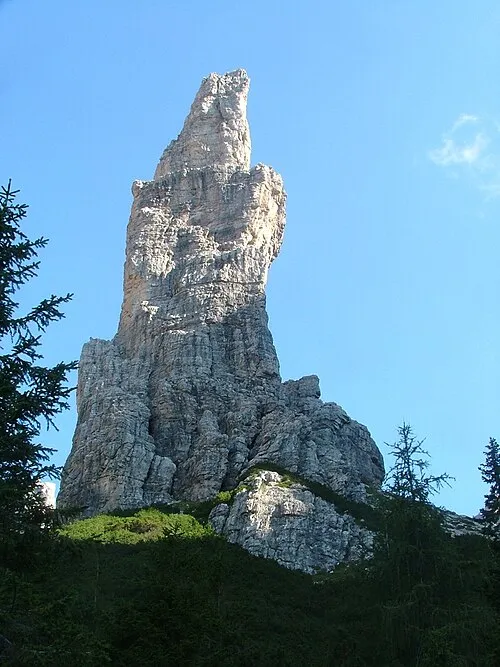
Campanile di Val Montanaia Antonio De Lorenzo · CC BY 2.5

Climate of Cima Sboada
Best months for sightseeingBest months for sightseeing: July–August.
This month · November
A cold month
Day 4° · Night -3° · Rain 97 mm
- Hottest month
- July (day 18°)
- Coldest month
- January (night -7°)
- Wettest month
- July (145 mm)
- Driest month
- January (52 mm)
Bars: average monthly low and high temperature. Below: precipitation. Monthly averages for 1970–2000 at about 18 km resolution, adjusted for elevation. Highlighted months are mild and relatively dry. Source: WorldClim 2.1 (CC BY 4.0).
Show values as a table
| Month | Jan | Feb | Mar | Apr | May | Jun | Jul | Aug | Sep | Oct | Nov | Dec |
|---|---|---|---|---|---|---|---|---|---|---|---|---|
| Average high (°C) | -1° | 1° | 3° | 7° | 12° | 15° | 18° | 18° | 14° | 10° | 4° | 0° |
| Average low (°C) | -7° | -7° | -4° | -2° | 3° | 7° | 9° | 9° | 6° | 2° | -3° | -6° |
| Precipitation (mm) | 52 | 52 | 68 | 91 | 122 | 138 | 145 | 136 | 117 | 111 | 97 | 62 |
How to get to Cima Sboada
The nearest airport is Treviso Airport (TSF), 85 km to the south as the crow flies. The nearest large city is Innsbruck, 130 km to the northwest.
Airports
- Treviso Airport (TSF) Treviso (TV) 85 kmsouth
- Bolzano Airport (BZO) Bolzano (BZ) 91 kmwest
- Trieste Airport (TRS) Ronchi dei Legionari/Trieste 96 kmsoutheast
Nearby large cities
- Innsbruck Population: 132.5K 130 kmnorthwest
- Klagenfurt Population: 100.3K 141 kmeast
- Ljubljana Population: 272.2K 159 kmeast
- Salzburg Population: 157.2K 163 kmnorth
- Rijeka Population: 108K 191 kmsoutheast
Straight-line distances; road distances are longer. Airport data: OurAirports.
Day trips from Cima Sboada
Within 100 km: 74 historic and cultural sites, 2,571 natural sites, 344 lakes, rivers and coasts.
0–25 km131 places
- Carnia Mountain 21 kmE
- Monte Sestier Mountain 25 kmS
- Monte Messer Mountain 23 kmS
- Monte Venale Mountain 22 kmS
25–60 km690 places
- Sille River 45 kmN
- Piz Gralba Mountain 57 kmW
- Piz Miara Mountain 57 kmW
- Croda Nera Mountain 56 kmW
60–100 km2,168 places
- Burano Island 99 kmS
- Prestreljenik Mountain 75 kmE
- Krn Mountain 90 kmE
- Vršič Mountain 96 kmE
Straight-line distances.
Nearest towns and villages
-
Forni di Sopra Municipality, Province of Udine7.9 km NE
-
Forni di Sopra Village, Forni di Sopra7.8 km NE
-
Villaggio Stinsans Village, Forni di Sopra8.3 km NE
-
Domegge di Cadore Municipality, Province of Belluno11 km NW
-
Pieve di Cadore Municipality, Province of Belluno12 km NW
-
Cimolais Village, Cimolais11 km SW
Nearby attractions & nature
Everything nearby-
Campanile di Val Montanaia Mountain, Cimolais2.8 km W
-
Croda Cimoliana Mountain, Veneto2.6 km NW
-
Cima Toro Mountain, Domegge di Cadore2.9 km NW
-
Pala Grande Mountain, Domegge di Cadore2.9 km NW
-
Cima Monfalcon Mountain, Cimolais3.3 km N
-
Monte Pera Mountain, Friuli Venezia Giulia3.5 km W
-
Cadin di Toro Mountain, Cimolais3.8 km W
-
Monte Piura Mountain, Cimolais3.9 km W
Sources & licences
Data last updated: · 2 independent sources